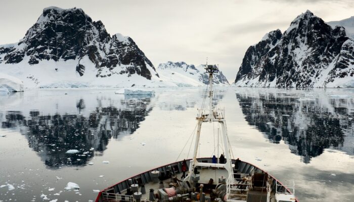
This week’s featured image depicts a quiet and still oceanic landscape in Antarctica, but polar scientists are studying how energetic and variable the ocean currents in this part of the world can be.
In this picture, the marine research vessel RRS James Clark Ross is making its way through the Lemaire Channel, a small passage off the coast of the Antarctic Peninsula, south of the southernmost tip of Chile. This channel is about 11 kilometres long and just 1,600 metres wide at its narrowest point, bordered by a spectacular range of steep cliffs.
At the time this photo was taken, the ship was headed to the Rothera Research Station, a British Antarctic Survey base on the white continent’s peninsula. The scientists aboard the vessel are part of a decades-long research campaign surveying the ocean current surrounding Antarctica, known as the Antarctic Circumpolar Current (ACC). The ACC is the world’s strongest and most influential current, transporting 165 million to 182 million cubic metres of water every second and connecting most of Earth’s major oceans. As such, any changes to the ACC have the potential to impact other marine environments around the world.
For more than 25 years, scientists from the UK’s National Oceanography Centre (NOC) have ventured south each Antarctic summer to measure the ocean’s physical features in one region of the Southern Ocean, called the Drake Passage. Spanning just 800 kilometres between the Falkland Islands and the Antarctic Peninsula, the Drake Passage is the shortest crossing from Antarctica to any other landmass. This makes it a prime spot to survey the ocean’s currents, as the flow is constricted to a narrow geographical region.
So far, researchers have completed 24 survey trips across the passage. The data collected during these trips have been used to assess how physical features of the ACC change, both throughout a single year and over the course of several years. Yvonne Firing at NOC leads the latest expeditions as part of the UK funded ORCHESTRA project. The continuation of this monitoring is helping scientists study how the ocean stores excess heat and carbon. No other ocean basin has been monitored so consistently, making the Drake Passage the most comprehensively studied part of the Southern Ocean.
By Olivia Trani, EGU Communications Officer
Imaggeo is the EGU’s online open access geosciences image repository. All geoscientists (and others) can submit their photographs and videos to this repository and, since it is open access, these images can be used for free by scientists for their presentations or publications, by educators and the general public, and some images can even be used freely for commercial purposes. Photographers also retain full rights of use, as Imaggeo images are licensed and distributed by the EGU under a Creative Commons licence. Submit your photos at http://imaggeo.egu.eu/upload/.