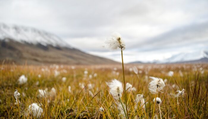
In the High Arctic, where vegetation is limited in height, cottongrass stands out as some of the tallest plant species around.
This photo shows a wispy white patch of Arctic cottongrass growing amongst other tundra vegetation in the Advent river floodplain of Adventdalen, a valley on the Norwegian archipelago island Svalbard.
Svalbard is of particular scientific interest as it is a relatively warm region for its high latitude. This is due to the North Atlantic Ocean, which transports heat from lower latitudes to Svalbard’s shores.
The photo was taken in September 2014, towards the end of the region’s growing season. In the background, you can see that the season’s first snow had already blanketed the valley’s neighboring mountain tops.
Cottongrass generally loves wet conditions and scientists sometimes even use this plant genus (Eriophorum) as an indicator of the ground’s fluctuating water level, especially in areas that begin to develop peat, an accumulation of more of less decomposed plant material in wet environments. The waters feeding this region’s wetland come from melted snow and ice travelling down the adjacent mountains and floodwater from the Advent river, which is primarily meltwater fed.
Arctic cottongrass also can exchange gases with their underground environment through their roots and even have been shown to alter the local carbon budget of regions where they grow. It is therefore a very important species to account for when studying permafrost carbon dynamics.
Gunnar Mallon, currently a teaching fellow at the University of Sheffield (UK), took this photo while on a fieldwork expedition together with Andy Hodson, a glaciology professor at the University Centre in Svalbard, for the LowPerm project.
The LowPerm project aimed to understand how nutrients are transported within permafrost landscapes in Norway and Russia and how that may affect the production of greenhouse gases, such as carbon dioxide (CO2) and methane (CH4). The study brought together scientists from the UK, Norway, Denmark and Russia and results from the extensive field and laboratory work are currently being analysed and made ready for publication.
Imaggeo is the EGU’s online open access geosciences image repository. All geoscientists (and others) can submit their photographs and videos to this repository and, since it is open access, these images can be used for free by scientists for their presentations or publications, by educators and the general public, and some images can even be used freely for commercial purposes. Photographers also retain full rights of use, as Imaggeo images are licensed and distributed by the EGU under a Creative Commons licence. Submit your photos at http://imaggeo.egu.eu/upload/.