Today’s post takes us to the far northern reaches of our planet, to a desert like nothing you’ve seen before.
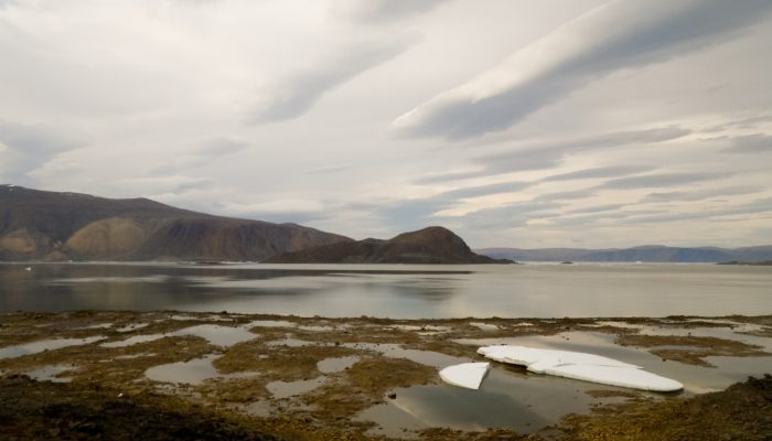
This picture is a view to the north across Alexandra Fjord, on the east coast of Ellesmere Island, in the Canadian High Arctic, with Sphynx island in the middle of the fjord. The south shore of Alexandra Fjord includes a polar oasis, an area of tundra vegetation and relatively mild climatic conditions normally found hundreds of kilometres further south. The oasis is surrounded by glaciers and icefields to the south, and polar desert on mountains to the east and west. Polar deserts can also be seen on the far shore in this picture; another scientist working in this area once described to me the ease of “doing geology” from the air due to the lack of plant or developed soil cover on much of the landscape.
The tundra ecosystems of the valley produce and consume greenhouse gases carbon dioxide, methane, and nitrous oxide because of the actions of soil dwelling microorganisms. The surrounding deserts appear nearly lifeless, with only scattered plants sheltered from the harsh winds on barren, rocky ground. Nonetheless, on a per-area basis these deserts contribute nearly as much to greenhouse gas processes as the oasis ecosystems, particularly nitrous oxide.
The surface of Alexandra Fjord freezes completely each winter, to a depth sufficient to support the weight of small aircraft. Researchers visiting this area in April and May land and take off from the ice, but we arrived in late June and used the raised beach cresh that sits some 100 metres inland as our runway. As the 24-hour daylight of summer warms the land and the sea, the ice breaks up and is flushed out towards the Davis Straight to the east. Small pieces of pack ice and small icebergs frequently ground on the shore of the fjord at each low tide, creating a stark and beautiful landscape of ice, land, and water that is best viewed at a distance due to the tendency of polar bears to wander along the shoreline in search of seals and other food.
By Martin Brummell, University of Waterloo, Ontario, Canada
Imaggeo is the EGU’s online open access geosciences image repository. All geoscientists (and others) can submit their photographs and videos to this repository and, since it is open access, these images can be used for free by scientists for their presentations or publications, by educators and the general public, and some images can even be used freely for commercial purposes. Photographers also retain full rights of use, as Imaggeo images are licensed and distributed by the EGU under a Creative Commons licence. Submit your photos at http://imaggeo.egu.eu/upload/.