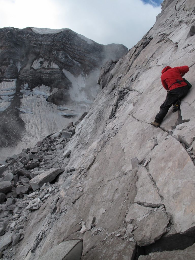
In the belly of the beast . Credit: Alexandra Kushnir (distributed via imaggeo.egu.eu)
Conducting research inside a volcanic crater is a pretty amazing scientific opportunity, but calling that crater home for a week might just be a volcanologist’s dream come true, as Alexandra postdoctoral researcher at the Institut de Physique du Globe de Strasbourg, describes in this week’s Imaggeo on Mondays.
This picture was taken from inside the crater of Mount St Helens, a stratovolcano in Washington State (USA). This particular volcano was made famous by its devastating explosive eruption in 1980, which was triggered by a landslide that removed most of the volcano’s northern flank.
Between 2004 and 2008 Mount St Helens experienced another type of eruption – this time effusive (where lava flowed out of the volcano without any accompanying explosions). Effusive eruptions produce lava flows that can be runny (low-viscosity) like the flows at Kilauea (Hawaii) or much thicker (high viscosity) like at Mount St Helens. Typically, high viscosity lavas can’t travel very far, so they begin to clump up in and around the volcano’s crater forming dome-like structures. Sometimes, however, the erupting lava can be so rigid that it juts out of the volcano as a column of rock, known as a spine.
The 2004 to 2008 eruption at Mount St Helens saw the extrusion of a series of seven of these spines. At the peak of the eruption, up to 11 meters of rock were extruded per day. As these columns were pushed up and out of the volcanic conduit – the vertical pipe up which magma moves from depth to the surface – they began to roll over, evoking images of whales surfacing for air.
‘Whaleback’ spines are striking examples of exhumed fault surfaces – as these cylinders of rock are pushed out of the volcano their sides grind against the inside of the volcanic conduit in much the same way two sides of a fault zone move and grind past each other. These ground surfaces can provide scientists with a wealth of information about how lava is extruded during eruption. However, spines are generally unstable and tend to collapse after eruption making it difficult to characterize their outer surfaces in detail and, most importantly, safely.
Luckily, Mount St Helens provided an opportunity for a group of researchers to go into a volcanic crater and characterise these fault surfaces. While not all of the spines survived, portions of at least three spines were left intact and could be safely accessed for detailed structural analysis. These spines were encased in fault gouge – an unconsolidated layer of rock that forms when two sides of a fault zone move against one another – that was imprinted with striations running parallel to the direction of extrusion, known as slickensides. These features can give researchers information about how strain is accommodated in the volcanic conduit. The geologist in the photo (Betsy Friedlander, MSc) is measuring the dimensions and orientations of slickensides on the outer carapace of one of the spines; the southern portion of the crater wall can be seen in the background.
Volcanic craters are inherently changeable places and conducting a multi-day field campaign inside one requires a significant amount of planning and the implementation of rigorous safety protocols. But above all else, this type of research campaign requires an acquiescent mountain.
Because a large part of Mount St Helens had been excavated during the 1980 eruption, finding a safe field base inside the crater was possible. Since the 2004-2008 deposits were relatively unstable, the science team set up camp on the more stable 1980-1986 dome away from areas susceptible to rock falls and made the daily trek up the eastern lobe of the Crater Glacier to the 2004-2008 deposits.
Besides being convenient, this route also provides a spectacular tableau of the volcano’s inner structure with its oxidized reds and sulfurous yellows. The punctual peal of rock fall is a reminder of the inherent instability of a volcanic edifice, and the peculiar mix of cold glacier, razor sharp volcanic rock, and hot magmatic steam is otherworldly. That is, until an errant bee shows up to check out your dinner.
By Alexandra Kushnir, postdoctoral researcher at the Institut de Physique du Globe de Strasbourg, France.
This photo was taken in 2010 while A. Kushnir was a Masters student at the University of British Columbia and acting as a field assistant on the Mount St Helens project.
Imaggeo is the EGU’s online open access geosciences image repository. All geoscientists (and others) can submit their photographs and videos to this repository and, since it is open access, these images can be used for free by scientists for their presentations or publications, by educators and the general public, and some images can even be used freely for commercial purposes. Photographers also retain full rights of use, as Imaggeo images are licensed and distributed by the EGU under a Creative Commons licence. Submit your photos at http://imaggeo.egu.eu/upload/.


