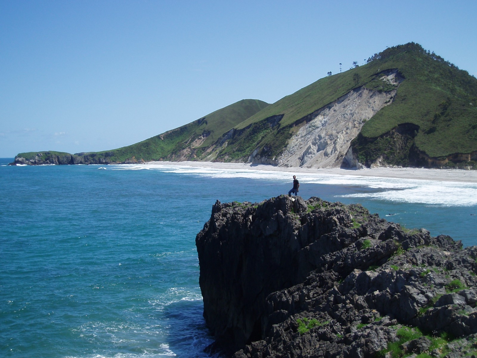
Shimmering blue seas, rocky outcrops and lush green hills sides; this idyllic landscape is punctuated by a stark reminder that geohazards are all around us. Irene Pérez Cáceres, a PhD student at the University of Granada (Spain) explains the geomorphology behind this small scale landslide on the Asturian coastline.
This picture was taken in May 2011 in the coast of Llanes (Asturias, Spain). I was living in Oviedo (Asturias, Spain) doing my Master in the structural geology of the Axial Zone of the Pyrenees. Thus, geomorphology and geohazards are not my specialty or area of expertise. However, the landslides are well known and studied in this region, and people from Asturias call them Argayos.
This argayo is situated in Niembru Mountain, over the San Antolín beach, constantly affected by waves and swell of tides of the Cantabrian Sea, and continuous rain typical in the region. It was defined as a rotational landslide with two fracture surfaces, possibly conjugated in wedge shape. It is approximately 50 meters high and 60 meters width at its base. The slide volume is calculated at 45000 m3. It is carved in quartzite altered by the water rain infiltration through crevices in the surface. The initial displacement was between 10 and 15 meters in the scar. Experts say this landslide is still active, moving and evolving continuously. It is an imminent risk for the swimmers, but it is very difficult to control it, due to the size and the slope, and the technical requirements to stabilize the rock. On the other side of this mountain, further landslides are evident, as a result of the building of a road.
These natural geomorphological processes are very common in the north of Spain, mainly in riverbeds, as well in other nearby beaches. The main causes are the abundant (and sometimes heavy) rainfall, the typically clay rich soils, steep slopes, building works that destabilize the slopes, and the absence of vegetation in some areas. They vary in in size and volume, and can sometimes have important material consequences and can pose a significant risk for the local inhabitants. The annual economic cost for repairing the damage caused by these processes is estimated to be 66 million of euros in this region.
Studies carried out in the Department of Geology of the University of Oviedo (Mª José Domínguez and her group), indicate that 70% of the landslides in Asturias happen when it rains over 200 mm during over a period of a minimum of three days. Research has also been carried out to try and predict when landslides might happen, examining numerous landslides over the last 20 years approximately. It seems that one conditioning factor is the exact location of new buildings, being that ancient constructions used to be in secure zones, probably because people observed more minutely to the nature, but the new ones are more vulnerable.
To conclude, detailed geological and geomorphological studies are always recommended to carry out before constructions. Thereby it is possible to minimise this common geohazard in Asturias.
By Irene Pérez Cáceres, PhD Student, Granada University.
If you pre-register for the 2015 General Assembly (Vienna, 12 – 17 April), you can take part in our annual photo competition! From 1 February up until 1 March, every participant pre-registered for the General Assembly can submit up three original photos and one moving image related to the Earth, planetary, and space sciences in competition for free registration to next year’s General Assembly! These can include fantastic field photos, a stunning shot of your favourite thin section, what you’ve captured out on holiday or under the electron microscope – if it’s geoscientific, it fits the bill. Find out more about how to take part at http://imaggeo.egu.eu/photo-contest/information/.


