The Canary Islands are often shown as a group of small dots in the vast Atlantic Ocean. However, across only a few tens of kilometres, their surrounding waters can shift from sheltered coastal bays and energetic inter-island channels to the open subtropical ocean. This strong environmental contrast makes the archipelago an ideal natural laboratory for observing how the ocean varies and responds to a changing climate. At the same time, the islands are home to communities whose lives and livelihoods are closely tied to the ocean, making the archipelago a natural platform for monitoring for both scientific and socioeconomic reasons. Understanding this variability requires looking beyond a single location and connecting observations across coastal, inter-island and open-ocean environments.
Since 2019, the Marine Chemistry research group, QUIMA, at the Institute of Oceanography and Global Change of the University of Las Palmas de Gran Canaria (IOCAG-ULPGC) has developed an observing network designed to connect these contrasting environments.
Observing the ocean from multiple platforms
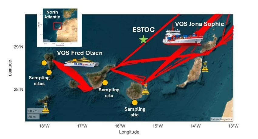
The network brings together two ships of opportunity (Volunteer Observing Ships; VOS), three oceanographic buoys, recurrent coastal sampling sites and the open-ocean ESTOC time-series station (Figure 1).
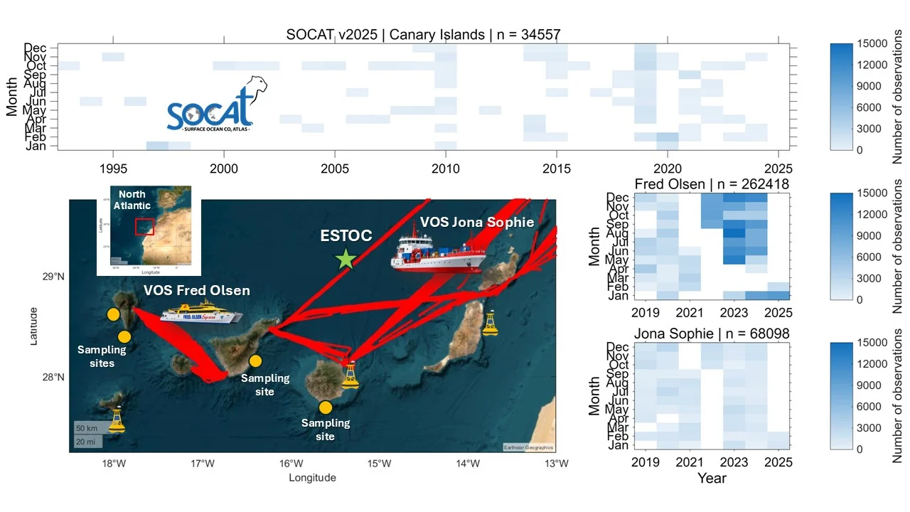
Figure 1. An overview of ocean observations around the Canary Islands. The upper panel shows the monthly distribution of observations available through SOCATv2025 (https://socat.info/) in the region. The lower-left panel presents the QUIMA observing network, including the routes of the VOS Benchijigua Fred Olsen Express and Jona Sophie, three coastal oceanographic buoys, recurrent coastal sampling sites and the open-ocean ESTOC time-series station. The right-hand panels show the monthly coverage provided by the two ship-of-opportunity lines since 2019. The heatmaps illustrate how the QUIMA observing network has substantially increased the number and frequency of observations collected around the archipelago compared with those available through SOCAT. Figure created by David Curbelo-Hernández using MATLAB.
A ship of opportunity is a commercial vessel equipped with scientific instruments that collect observations while the ship continues its regular route. Repeated journeys therefore make it possible to monitor the same ocean regions frequently without relying exclusively on dedicated research cruises.
The QUIMA network has operated aboard two such vessels. The inter-island ferry Benchijigua Express, operated by Fred. Olsen Express, crosses the western Canary Islands daily. The cargo vessel Jona Sophie operated between 2019 and 2025, sailing weekly between the easternmost Canary Islands and the Iberian Peninsula. The observing equipment has since been installed aboard the Buenavista Express, also operated by Fred. Olsen Express. This observing line is part of ICOS-ERIC as a Class 1 Ocean Station (ID: ES-SOOP-CanOA).
The oceanographic buoys are located in shallow coastal waters or nearshore environments around different islands. Together, these platforms provide a high-resolution view of spatial and temporal variability in the ocean carbon cycle and air–sea CO2 exchange, from coastal waters to the open ocean.
Why high-resolution observations matter around islands
The value of the network is that it collects observations frequently and across strong environmental gradients. During a single journey, a vessel can connect coastal waters, inter-island channels and the open Atlantic. Repeating these routes throughout the year helps reveal seasonal cycles, short-lived events and persistent contrasts between different parts of the archipelago.
A comparison with observations available through SOCAT reveals an important data gap around the Canary Islands, where historical coverage has been relatively sparse and irregular. Since 2019, the two QUIMA ship lines have substantially helped to fill this gap, generating hundreds of thousands of repeated measurements across different seasons and years. These observations allow intra-annual variability to be examined in much greater detail, while the continued operation of the network will be essential for detecting long-term trends.
These observations complement global synthesis products by adding the spatial and temporal detail needed to understand how coastal, inter-island and open-ocean waters differ, and how each environment responds to global change.
The people behind an “autonomous” network
It is easy to imagine that an autonomous instrument simply measures the ocean by itself. In reality, autonomous does not mean unattended.
Every data point depends on people installing instruments aboard ships and buoys, adapting seawater and atmospheric intakes, checking pumps and tubing, replacing sensors and calibration gases, cleaning equipment, coordinating access with vessel crews and responding when something stops working. Once the measurements reach the laboratory, they still need to be inspected, processed and quality controlled before they can be used confidently.
Having worked with this network, I came to appreciate how important it is to make visible the work of the scientists and technicians behind every dataset. High-quality ocean observations do not happen by themselves: they depend on the time, expertise and commitment of many people. I have seen first-hand how much effort lies behind what may look like a simple time series. This sustained work is essential if we want reliable data to understand the ocean, climate change and their impacts on marine ecosystems. Long-term ocean observation is therefore not only about instruments and technology, but also about people, cooperation and continuity.
A network built through cooperation, with benefits for island communities
The network began with the support of the Loro Parque Foundation and the Canary Islands Government, which promoted several initiatives to strengthen ocean observation in the archipelago. Among them was the CanOA project, developed within the CanBIO programme, with a particular focus on monitoring ocean acidification. This effort was later expanded by the Canary Islands Government through CARBOCAN, the Canary Islands CO2 System Observation Network. Since then, the network has continued to grow, both in the number of observations and in its geographic scope, thanks to support from different projects. In particular, the Interreg MAC programme has helped extend these efforts beyond the Canary Islands, using the observations as a basis for cooperation with other Macaronesian archipelagos through projects such as PLANCLIMAC and PLANCLIMAC2.
These newer monitoring sites also complement the ESTOC time-series station, located north of the Canary Islands, which has been operating since 1995. The value of the newer records increases with every year of observations, helping to build an increasingly complete picture of how the ocean around the archipelago is changing. This continuity is particularly important in archipelagic regions such as the Canary Islands, where communities, economies and cultural identities are closely connected to the ocean. Fisheries, tourism, coastal activities and marine ecosystems may all be affected by changes in ocean temperature, chemistry and productivity.
Sustained monitoring provides the environmental baseline needed to identify change, distinguish short-term variability from long-term trends and support informed mitigation and adaptation strategies. In addition, Ocean Observations are climate actions and governance. How can we decide public policy or changes in the governance systems for climate change without data? Hopefully, the experience gained through this network can also contribute to the development of similar observing systems in other archipelagic regions, many of which face comparable challenges but remain poorly monitored.
Further reading
- Learn more about the QUIMA Marine Chemistry research group and its ocean carbon observing activities in the Canary Islands.
- Explore the ES-SOOP-CanOA Ocean Station within the ICOS European research infrastructure.
- Discover the Surface Ocean CO2 Atlas (SOCAT) and its global collection of quality-controlled surface-ocean CO2
References
- Curbelo-Hernández, D., González-Dávila, M., González, A. G., González-Santana, D., and Santana-Casiano, J. M. (2021a). CO2 fluxes in the Northeast Atlantic Ocean based on measurements from a surface ocean observation platform. Science of the Total Environment, 775, 145804. https://doi.org/10.1016/j.scitotenv.2021.145804.
- Curbelo-Hernández, D., Santana-Casiano, J. M., González, A. G., and González-Dávila, M. (2021). Air–sea CO2 exchange in the Strait of Gibraltar. Frontiers in Marine Science, 8, 745304. https://doi.org/10.3389/fmars.2021.745304
- González, A. G., Aldrich-Rodriguez, A., Gonzalez-Santana, D., González-Dávila, M., & Santana-Casiano, J. M. (2024). Seasonal variability of coastal pH and CO2 using an oceanographic buoy in the Canary Islands. Frontiers in Marine Science, 11, 1337929. https://doi.org/10.3389/fmars.2024.1337929
- Curbelo-Hernández, D., González-Santana, D., González, A. G., Santana-Casiano, J. M., and González-Dávila, M. (2025). Spatiotemporal variations in surface marine carbonate system properties across the western Mediterranean Sea using volunteer observing ship data. Biogeosciences, 22, 3329–3356. https://doi.org/10.5194/bg-22-3329-2025.
- Sánchez-Mendoza, I., González-Dávila, M., González-Santana, D., Curbelo-Hernández, D., Estupiñán-Santana, D., González, A. G., and Santana-Casiano, J. M. (2026). Modelling seawater pCO2 and pH in the Canary Islands region based on satellite measurements and machine learning techniques. Ocean Science, 22, 609–628. https://doi.org/10.5194/os-22-609-2026.
Follow the QUIMA-IOCAG group
For updates on fieldwork, research projects, publications and other activities, follow the QUIMA-IOCAG group on https://eacfe-quima.blogspot.com/, Instagram (@quima_ulpgc) and Facebook (QUIMA.IOCAG).