
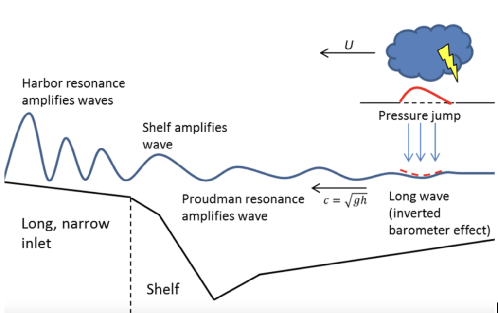
Meteotsunamis or meteorological tsunamis are globally occurring progressive shallow water waves with a period of between 2 to 120 minutes which results from an air-sea interaction. They tend to be initiated by sudden pressure changes and wind stress from moving atmospheric systems with sources ranging from convective clouds, cyclones, squalls, thunderstorms, atmospheric gravity waves and strong mid-tropospheric winds (Vilibić and Šepić, 2017). The atmospheric pressure changes are typically only a few mb over a few tens of minutes which corresponds to only a few centimetres of sea level change occurring in a process known as the inverse barometer effect (for example, a 3 mb pressure jump will produce a 30 cm ocean wave). The atmospheric disturbance transfers energy into the ocean initiating and amplifying a water wave which travels at the same speed as the atmospheric wave, in a process known as Proudman resonance (Proudman, 1929). When the water wave reaches the coastline and shallower water, it becomes a multi resonant phenomenon and is further amplified through coastal resonances (Figure 1). For example, if the wave reaches the entrance of a semi enclosed basin it can induce an oscillation in the basin known as harbour resonance. However, if the wave reaches a beach type environment and the long shore component of the disturbance equals the phase speed of the edge wave this is a process known as Greenspan resonance (Monserrat et al. 2006). The resultant waves can elevate the coastal water level and can substantially increase flow velocities with the potential for rip currents (Linares et al. 2019).
Due to the rapid onset and unexpected nature of meteotsunami waves, they have the potential to cause destruction, injuries and even fatalities (Sibley et al. 2016). This has been apparent throughout recent history with an increase in the number of meteotsunami being experienced around the world. With extreme events such as those in Vela Luka (Croatia, 1978) where a 6m wave caused US$7 million damage; at Nagasaki (Japan, 1979) where an event killed three people; Daytona Beach (Florida, 1992) where a single 3 m wave injured 75 people and caused damage to dozens of cars and the Persian Gulf (2017) where a squall line initiated a 2.5 m wave leaving 22 injured and five dead (Gusiakov, 2021). For a global perspective and overview of meteotsunami observations we recommend Pellikka et al. (2020) for observations in Finland, Šepić et al. (2018) for the Adriatic, Belche et al. (2016) for seasonality of meteotsunami in the Great Lakes, Pattiaratchi and Wijeratne (2015) for observations in southwest Australia and Monserrat, Rabinovich and Vilibić (2006) provide a general overview of the mechanisms of meteotsunami.
Meteotsunami research and monitoring is more advanced in the Mediterranean, the East Coast of the USA, and the Great Lakes due to the higher number of recorded events. However, events in the UK number over 115 recorded between 1750 and 2025 (Figure 2) and this number may be a lot greater due to the lack of a high-resolution tide gauge network (Lewis et al. 2023). Previous work has suggested that meteotsunami are rare events, and occur more frequently during the summer, initiated by convective storms (Haslett et al. 2009, Sibley et al. 2012, Tappin et al. 2013 and Thompson et al. 2020). However, recent work has shown a prominent seasonal pattern of winter events related to mid latitude depressions with precipitating convective systems (Lewis et al. 2023 and Williams et al. 2021). A geographical pattern has also emerged showing three hotspot areas along the south and southwest England and the northwest of Scotland, this is mainly due to the dominant direction of flow of the UK weather systems and morphological coastal features (Sibley et al. 2016, Lewis et al. 2023 and Williams et al. 2021).
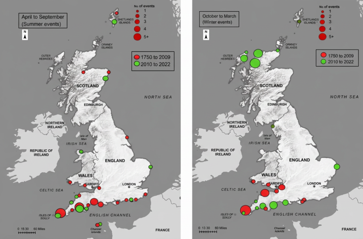
Figure 2: Seasonal and locational distribution of maximum wave heights from 1750 to 2022. Numbers of events at specific locations are represented by dot size as shown in the key. Base map: © Crown copyright 2022. Distributed under the Open Government Licence (OGL). Note that, regarding the scale, 1 mi is 1.609 km. (Lewis et al. 2023)
Research has shown that meteotsunami can occur anywhere in the world where the atmospheric conditions and coastline configuration are conducive for the production and amplification of these waves. There is a misconception of the risk posed by meteotsunami especially for coastal areas that are already at risk from storm impacts associated with pluvial (extreme precipitation) and fluvial hazards (high levels of river discharge). As stated by Šepić et al. (2015) the assessment of meteotsunami should become the standard in coastal hazard assessments, event cataloguing is a pre-requisite for any coastal hazard assessment especially in identifying the geographical areas that have experienced meteotsunami and the frequency of exposure. In the future the overall level of risk is likely to be greatly exacerbated by rising sea levels and an intensification of storm frequency and severity as a result of a changing climate (Vilibić et al. 2018; Masselink et al. 2015).
References
Bechle, A.J., Wu, C.H., Kristovich, D.A.R., Anderson, E.J., Schwab, D.J. & Rabinovich, A.B. 2016. Meteotsunamis in the Laurentian Great Lakes. Scientific Reports 6, (37832). https://doi.org/10.1007/s11069-014-1193-5
Gusiakov, V. 2021. Meteotsunamis at global scale: problems of event identification, parameterisation, and cataloguing. Natural Hazards. 106. 1105–1123,
Haslett, S.K. & Bryant, E.A. 2009. Meteorological Tsunamis in Southern Britain: An Historical Review. Geographical Review. 99, 146–163. https://doi.org/10.1111/j.1931-0846.2009.tb00424.x
Lewis, C., Smyth, T., Williams, D., Neumann, J., & Cloke, H. 2023. Meteotsunami in the United Kingdom: the hidden hazard. Natural Hazards and Earth System Sciences, 23, 2531– 2546. https://doi.org/10.5194/nhess-23-2531-2023
Linares, Á., Wu, C.H., Bechle, A.J., Anderson, E.J. & Kristovich D.A.R. 2019. Unexpected rip currents induced by a meteotsunami. Sci Rep 9:2105. https://doi.org/10.1002/2016JC011979
Monserrat, S., Vilibic, I. & Rabinovich, A.B. 2006. Meteotsunamis: atmospherically induced destructive ocean waves in the tsunami frequency band. Natural Hazards and Earth System Science. 6. 1035-1051. https://doi.org/10.5194/nhess-6-1035-2006.
NOAA, 2014. An examination of the June 2013 East Coast meteotsunami captured by NOAA Observing systems. NOAA Technical Report NOS CO-OPS 079. Silver Spring Maryland.
Pattiaratchi, C.B. and Wijeratne, E.M.S. 2015. Are meteotsunamis an underrated hazard? Philosophical Transactions of the Royal Society: Mathematical and Engineering Sciences 373. https://doi.org/10.1007/s11069-014-1263-8
Pellikka, H., Laurila, T.K., Boman, H., Karjalainen, A., Björkqvist, J. & Kahma, K.K. 2020. Meteotsunami occurrence in the Gulf of Finland over the past century, Natural Hazards Earth System Sciences. 0. (9). 2535-2546. https://doi.org/10.5194/nhess-20-2535-2020
Proudman, F.R.S. 1929. The Effects on the Sea of Changes in Atmospheric Pressure. Geophysical Journal International 2 s4. https://doi.org/10.1111/j.1365-246X.1929.tb05408.x
Šepić, J., Vilibić, I., & Fine, I. 2015. Northern Adriatic meteorological tsunamis: Assessment of their potential through ocean modelling experiments. J. Geophysics. Res. Oceans, 120, 2993–3010, https://doi.org/10.1002/2015JC01079
Šepić, J., Vilibić, I., Rabinovich, A., & Tini, S. 2018. Meteotsunami (‘‘Marrobbio’’) of 25–26 June 2014 on the Southwestern Coast of Sicily, Italy. Pure Applied Geophysics. 175: 1573–1593. https://doi.org/10.1007/s00024-018-1827-8
Sibley, A. 2012. Thunderstorms from a Spanish Plume event on 28 June 2011. Weather. 67. No 6. 143-152. https://doi:10.1002/wea.1928.
Sibley, A., Cox, D., Long, D., Tappin, D.R. and Horsburgh, K.J. 2016. Meteorologically generated tsunami like waves in the North Sea on 1 July 2015 and 28 May 2008. Weather. 71. 68-74. https://doi.org/10.1002/wea.2696
Tappin, D.R., Sibley, A., Horsburgh, K.J., Daubord, C., Cox, D. and Long, D. 2013. The English Channel `tsunami’ of 27 June 2011 – a probable meteorological source. Weather. 68. 144–152. https://doi.org/10.1002/wea.2061
Thompson, J., Renzi, E., Sibley, A. and Tappin, D. 2020. UK meteotsunamis: a revision and update on events and their frequency. Weather. 75.9, 281–287. https://doi.org/10.1002/wea.374
Vilibić, I. and Šepić, J. 2017. Global mapping of non-seismic sea level oscillations at tsunami timescales. Scientific reports. 7. (1)
Vilibić, I., Šepić, J., Dunic, N., Sevault, F., Monserrat, S. and Jorda, G. 2018. Proxy-based Assessment of Strength and Frequency of Meteotsunamis in Future Climate. Geophysical Research Letters. 45. 10501-10508. https://doi.org/10.1029/2018GL079566
Williams, D. A., Schultz, D. M., Horsburgh, K. J., and Hughes, C. W. 2021. An 8-yr meteotsunami climatology across northwest Europe: 2010–2017. Journal of physical oceanography. 1145-1160. https://doi.org/10.1175/JPO-D-20-0175.1