Deciphering Earth’s geological history is no easy feat. For undergraduate students beginning their journey in geology, identifying a rock and drawing connections with relevant geodynamic processes occurring over millions of years can be a challenge. In this week’s blog post, Phillip Ruscia explains how virtual reality (VR) and the High Immersion Virtual Experiences (HIVE) research lab at the University of Toronto are bridging the “abstraction gap” and preparing the next generation of geoscientists.

Phillip Ruscica, University of Toronto, Canada
Geodynamic processes span millions of years and vast spatial scales, far beyond what anyone can witness in a single lifetime. To reconstruct past geological processes, geologists analyze pieces of evidence, such as a segment of a fold, a fossil in a limestone, or a striation on a rock. For an expert, a marine fossil becomes a tropical sea teeming with life; for a student, however, this leap of imagination can be a significant challenge.
The Problem of Abstraction in Geoscience
In the “Earth History” undergraduate course at the University of Toronto Scarborough campus (UTSC), students explore roughly 4 billion years of geological history, focusing on how geodynamic processes shaped our planet’s atmosphere, oceans, biology, and climate. The course traditionally emphasizes hands-on identification of fossil, rock, and mineral specimens in weekly labs and links them to larger geological processes, such as ocean formation, subduction, mountain-building, erosion, and deposition.
The link between these processes and the physical rock record is rarely clear to students. Students struggle to grasp the three-dimensional nature of these processes and to connect a local observation to its regional story. Part of the problem is that the specimens students analyze carry little of what would make them meaningful. For example, a marine fossil in a lab drawer has been stripped of the sea it once inhabited. Another challenge is that pristine samples bear little resemblance to the imperfect, weathered rocks and fossils students will eventually encounter in the field. Bridging this gap requires more than examining a specimen up close — it requires letting students step inside the environments and timescales a specimen has been removed from. This is precisely where immersive technology earns its place in the geoscience classroom.
A marine fossil in a lab drawer has been stripped of the sea it once inhabited.
A New Kind of Facility: Immersive Virtual Reality
Virtual Reality (VR) is an immersive technology that simulates an entirely digital world where the user feels a sense of “presence” through a stereoscopic headset and haptic per-hand controllers. In this digital space, there are essentially no limits on what can be seen or done.
Once immersed, users can explore the limitless nature of the digital world, where real and created objects seamlessly blend with whatever behaviours, guidance, gamification, and active learning the activity calls for. Objects can be captured directly through photogrammetry, modelled or AI-generated from real-world references, or made wholly fictional, as in video games. Their behaviour can follow real data or depart from it entirely — changing how they move, appear, and respond. In our applications, real data drives the components that matter most: the visual detail, behaviour of key objects, and the actions available to the user.
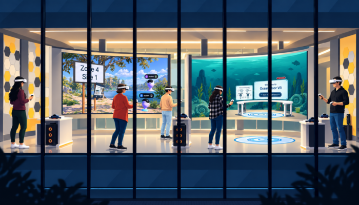
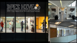
To bring VR into the course, we established the DPES HIVE, a dedicated VR facility at UTSC supported by a $100,000 departmental research grant. The HIVE houses seven specialized stalls, each equipped with a custom smart wall and high-end hardware, including the HTC Vive Pro 2 and Meta Quest 3 headsets.
The layout is designed for maximum pedagogical support. Each student has their own “play area” for movement, while supervisors can monitor the student’s view on external monitors. This setup allows hands-on, tailored support, ensuring that even students new to VR can successfully navigate the digital world.
A Three-Stage Pedagogical Arc: From “Specimen-to-Setting-to-Stone”
To address the abstraction gap and the disconnect between theory and fieldwork, we structured the practical component of the course into three escalating stages:
Stage 1: Building Core Skills in the Lab
Students first use traditional methods to identify fossil, rock, and mineral specimens through hands-on practicals with physical samples. This allows students to learn the core skills of observation and classification. In our course, fossil identification focuses on Silurian-Devonian fossils from Southern Ontario, Canada.
Stage 2: Deep Immersion in VR – Ocean Floor VR App
Stage 2 utilizes our newly developed Ocean Floor VR application, designed to introduce students to VR while reinforcing fossil identification. This application features four visually distinct ocean zones – the epipelagic, mesopelagic, bathypelagic, and the combined abyssopelagic/hadopelagic.
As students “descend” through each zone, they encounter fossils in an original environment or setting. Each environment features unique characteristics, such as water depth, lighting, grain size, and even marine species swimming throughout the scene.
Students can pick up and examine digital fossils, consult information panels, and answer questions via the university’s academic web platform integrated directly into the VR experience. By the time students complete the exercise, a fossil hand-sample is no longer an isolated object – it holds an ocean and the millions of years that shaped it.
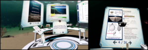
A fossil hand-sample is no longer an isolated object – it holds an ocean and the millions of years that shaped it.
Stage 3: Virtual and Physical Field Trip into the Devonian!
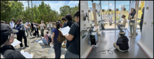
With VR familiarity established, the final stage focuses on exploring a stone quarry, where Devonian fossiliferous limestone is well exposed. Here, students transition from “ideal” specimens to real-world challenges. In a VR replica of the quarry, students work in pairs to identify rock types and geological features, such as joints, striations, and imperfect fossils often half-hidden in the rock. Using a virtual compass, they also measure the trend of joints and striations.
By practicing these skills in VR first, students are better prepared for their in-person field trip to the quarry. In both formats (virtual and in-person), students also discuss the region’s geological history since the Devonian, helping them connect the physical rock record to the geological processes that shaped the area.
The Limitless Role of VR in Teaching and Research
We continue to evolve through student feedback, refining our design with a steady goal: to send the next generation of geoscientists into the field not only better prepared for fieldwork but with the trained ability to perceive deep time and the planet-scale processes that a single specimen can only hint at. As the DPES HIVE evolves, we hope the “specimen-to-setting-to-stone” arc is more than just a course sequence; it is a template for the future of geoscience education—one we believe could extend to any field.
VR also has meaningful potential in research. For example, we’re working on a “VR-crystal experience” that enables atomic-scale exploration of crystal structures. Students can manipulate lattices, measure parameters, and classify minerals while interactively visualizing symmetry, bonds, and 3-dimensional atomic arrangements. We also have VR applications in development for visualizing the results of ecological modelling. The goal is to transfer expert knowledge of environmental problems, along with concepts such as “uncertainty” and “risk”, to stakeholders, policymakers, scientists, and the public. Because VR allows us to combine real data with simulated behaviours, the potential is truly limitless.
Interested in bridging immersive visualization into your work? We’d love to hear from you!
Arhonditsis, G.B., Neumann, A., Ruscica, P., Javed, A., Daxberger, H., 2023. Integration of Bayesian Inference Techniques with Mathematical Modeling, in: Reference Module in Earth Systems and Environmental Sciences. Elsevier, p. B9780323907989000767. https://doi.org/10.1016/B978-0-323-90798-9.00076-7

Ruscica, P., Daxberger, H., Resch, G., Hadzovic, A., Dalili, S., Arhonditsis, G.B., 2026. Transforming education and research with extended reality technologies: How virtual reality can shape the future of data interactions in earth and environmental sciences. Ecol. Inform. 93, 103535. https://doi.org/10.1016/j.ecoinf.2025.103535