Fig. 1: Group photo with Mount Everest backdrop following presentations at the Sagarmatha National Park office in Namche Bazar (3,500 m a.s.l) with 60 participants (wrapped up against the cold temperatures). [Credit: Dhananjay Regmi].
The 12 day “Walk the Talk” Field Conference and Community Consultation through Sagarmatha National Park, Nepal, discussed a wide range of research outputs with local communities, tourists, and officials. Topics covered glaciers, mountains, environmental and landscape change, Sherpa livelihoods, tourism, and natural hazards. The conference, organised by Himalayan Research Expeditions, was the first of its kind, designed to receive community input into research topics and pursue applied benefits. Scott and Katie were two of the participants, presenting work from their PhDs in the Everest region and the NERC-funded EverDrill project.
Presentations and discussions
The team of international and Nepali scientists gave presentations every evening, trekking each day between six different villages along the Everest Base Camp trail. We were also joined by officials from the Nepal Department of Tourism and the Mountain Institute. The highest destination for the conference was Imja Glacial Lake, at over 5,000 m elevation, where we viewed first-hand the results of a recent $7 million project to lower the lake water level, aiming to reduce the risk of an outburst flood.
The Sagarmatha National Park has been a focus for scientists of many disciplines for decades. As well as thousands of tourists trekking to Everest Base Camp each year, it is also frequented by those hoping to summit Mount Everest (Sagarmatha). The park has therefore experienced significant change over a relatively short timescale as it copes with this huge influx of people. Presentations for the “Walk the Talk” conference ranged from impacts of tourism (for example, on local people, yak breeding and waste disposal) to natural hazards such as glacial lake outburst floods and landslides.
Katie presented ongoing work from her PhD and the “EverDrill” project (Fig. 2), for which she has conducted several field seasons on Khumbu Glacier in the Sagarmatha National Park. Fieldwork has included hot-water drilling of boreholes into the glacier and installing sensors to measure ice temperature at various depths to investigate the glacier’s thermal regime. She discussed how these measurements showed that Khumbu’s ice is warmer than expected, potentially putting the glacier at risk of more rapid melting as air temperatures rise. The warmer ice towards the terminus also allows subsurface meltwater drainage, about which very little is known. Katie has also carried out fluorescent dye tracing experiments to work out how meltwater travels through Khumbu Glacier, including storage within (englacial) and on the surface (supraglacial). As Khumbu and similar glaciers retreat in the future, meltwater storage and runoff will have implications for the downstream communities who depend on such water sources.
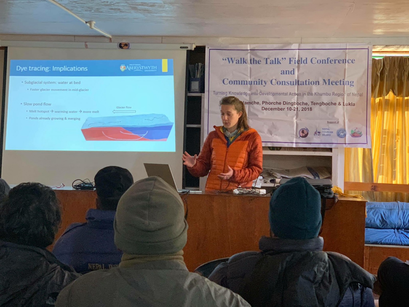
Fig. 2: Katie presenting measurements of Khumbu Glacier’s thermal regime and hydrology at the Sagarmatha National Park headquarters in Namche Bazar (3,500 m a.s.l.). [Credit: Dhananjay Regmi].
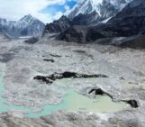
Scott presented results from his PhD investigating melt processes and water storage on Khumbu Glacier (Fig. 3). Areas of Khumbu Glacier have thinned by up to 80 m over the last three decades and glacier flow is slowing down, which allows meltwater to pond on the glacier surface. The rugged glacier surface is pitted with ice cliffs and ponds, which act as hot-spots of melt in areas of the glacier otherwise insulated by a thick layer of rocks and sediment (debris-cover). The rapid formation, persistence, and drainage of meltwater stored on glaciers across the Himalaya is a growing concern due to the potential for outburst floods and increased rates of glacier melt. An outburst flood event that occurred in the Everest region in 2017 destroyed trekking trails and a bridge.
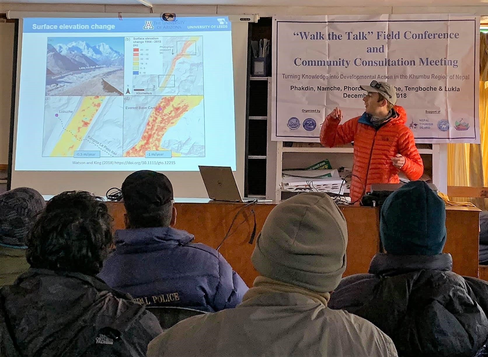
Fig. 3: Scott presenting a study of glacier thinning at the Sagarmatha National Park office in Namche Bazar (3,500 m a.s.l). [Credit: Dhananjay Regmi].
After the final day of trekking, an extra night was spent in the village of Lukla, before flying back to Kathmandu. Each presentation was summarised in a few slides, and collated into a full talk that was given in Nepali by Dr. Dhananjay Regmi, organiser of the conference and head of Himalayan Research Expeditions. By presenting all our research in Nepali, more local people attended and were able to hear about and suggest new directions for research in the valley. This presentation was given again two days later, also in Nepali, at the Department of Tourism in Kathmandu, for locals who had already travelled back to the city to avoid the high-elevation winter chill.
Outreach activities
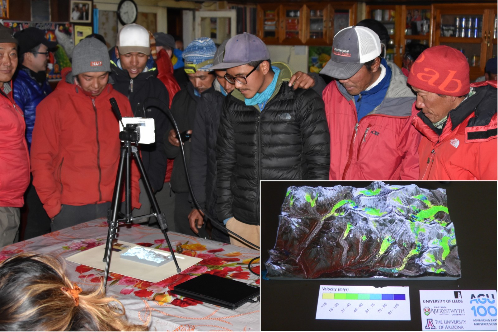
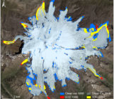
Fig. 4: The projection augmented relief model shown after presentations in the village of Phortse. The inset shows glacier velocity data projected onto the glaciers in the Everest region. [Credit: Gu Changjun and Scott Watson].
We designed outreach activities and leaflets to enhance the PowerPoint presentations given at each village by providing interactive demonstrations of key research concepts and results. Scott used an AGU Celebrate 100 grant to design a projection augmented relief model (PARM) of the Everest region (Fig. 4). The PARM system projected research results including glacier velocity, mass loss, ice thickness, temperature, and animations of glacier flow, onto a 3D model, which stimulated discussion of the research. The 3D model allowed the local communities to easily visualise the data in the context of well-known mountain peaks and glaciers, and to observe the changing environment (such as the expansion of Imja Lake) from a projected time-lapse animation.
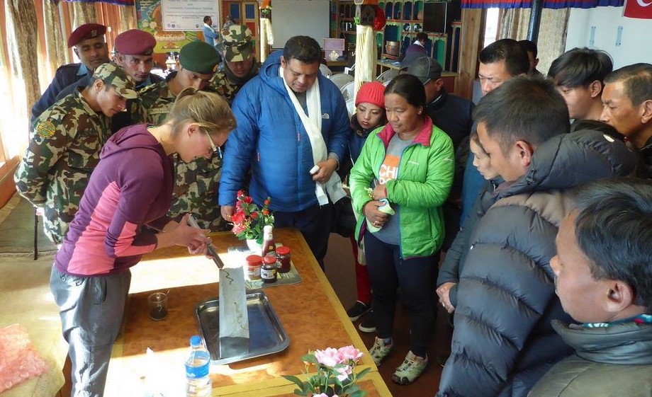
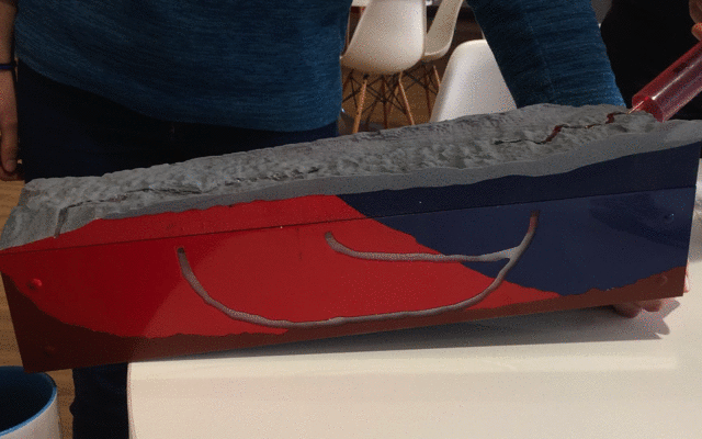
Fig. 5: Katie demonstrating glacier thermal regime and hydrology using a 3D model to conduct example dye tracing experiments. The lower panel is a GIF showing the dye tracing. [Credit: Scott Watson and Katie Miles].
Katie’s interactive outreach was to demonstrate dye tracing experiments on a 3D model of Khumbu Glacier (Fig. 5). Food colouring was used to “dye” the water, which was “injected” into a supraglacial stream, then “disappeared” into the glacier. The side view into the glacier showed this water flowing through and beneath the ice, before emerging back at the surface, flowing through surface ponds and exiting the glacier at its terminus. The side view also showed the approximate ice temperatures measured by the EverDrill project, which actively showed where (and why) the glacier is experiencing more melt.
The model was very well received by scientists and locals – while the water was being injected, we would explain what was happening in both English and Nepali, and there were always plenty of questions. While the dye tracing experiments didn’t work perfectly every time, surface floods offered an opportunity to talk about other hazards that have been recently observed on Khumbu Glacier.
Summary
The “Walk the Talk” Field Conference and Community Consultation was a new style of conference, aiming to communicate a wide range of research topics in the Everest region of Nepal and the Sagarmatha National Park. The combination of high-elevation trekking and presentations was sometimes tiring, but the trek facilitated discussions about the landscape we were immersed in and was a fantastic learning experience. It is hoped that the conference will travel to different locations in the future to share research and understand the priorities of other communities in Nepal.
Further reading
- A blog of the trek is available at https://walk-talk.com/blog/
- Image of the Week – Climbing Everest and highlighting science in the mountains
- Image of the Week – Making waves: assessing supraglacial water storage for debris-covered glaciers
- Image of the Week – Drilling into a Himalayan glacier
- Image of the Week – Fieldwork at 5,000 meters in altitude
- Image of the Week – Far-reaching implications of Everest’s thinning glaciers
- Image of the Week – Supraglacial debris variations in space and time!
- Image of the Week – Getting glaciers noticed!
- The Conversation – Why we’re drilling into the world’s highest glacier on Everest with a converted car wash
- The Conversation – Warm ice in Mount Everest’s glaciers makes them more sensitive to climate change – new research
Edited by Violaine Coulon
 Scott Watson is a Postdoc at the University of Arizona, USA, studying glaciers in the Everest region and the surface interactions of supraglacial ponds and ice cliffs. He also investigates natural hazards and glacial lake outburst floods. Tweets @CScottWatson. Website: www.rockyglaciers.co.uk
 Katie Miles is a PhD student at the Centre for Glaciology, Aberystwyth University, UK, studying the internal structure and subsurface hydrology of high-elevation debris-covered glaciers in the Himalaya through borehole-based investigations and dye tracing experiments. Tweets @Katie_Miles_851. EverDrill website: www.EverDrill.org