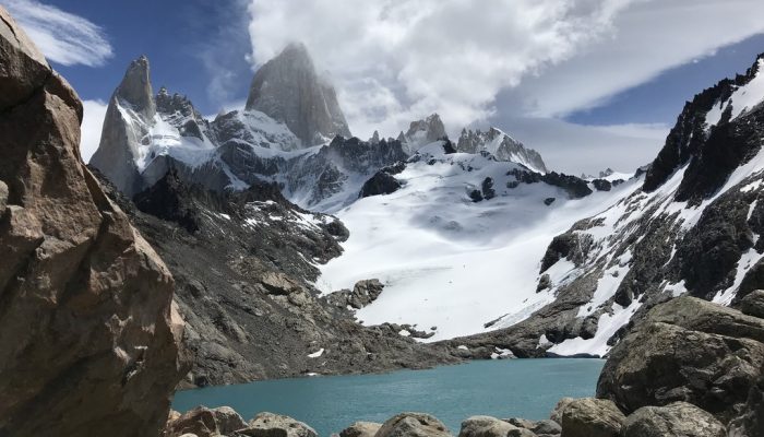
Pictured here is a snapshot of an environment in transition. Today’s featured photo was taken at the foot of Monte Fitz Roy, a jagged Patagonia mountain located in Los Glaciares National Park on the border between Argentina and Chile.
The Patagonia region in South America is the second biggest source of glaciers in the southern hemisphere, behind Antarctica, but the region is losing ice at a rapid rate.
Satellite imagery analysis over the last few years has suggested that the Patagonia region is losing ice more than any other part of South America, with some glaciers shedding ice faster than any place in the world.
A recent study reported that the northern and southern Patagonia ice fields in particular are losing roughly 17 billion tons of ice each year. Los Glaciares National Park alone is home to around 50 large glaciers, but because of warming temperatures, almost all of these large ice masses have been shrinking over the last 50 years.
This level of glacial ice loss can be hard to fully imagine, but in 2017, Shauna-Kay Rainford, a PhD student at Pennsylvania State University in the United States and photographer of this featured image, got a first-hand glimpse of Patagonia’s changing landscape.
“Ensconced between the granite boulders I felt like I was at a pivotal moment of continued change,” said Rainford. “While the peaks of Mt. Ritz Roy remain and will likely remain tall and majestic, with each passing year the glacier continues to retreat further towards the peak and the glacial lake continues to expand more and more.”
Rainford had reached this scenic yet tragically ephemeral view after a strenuous hike up the mountain. “It was very emotional to think about what this view will look like in the future if I should ever visit the mountain again,” Rainford recalls. “It is always striking to be confronted with the adverse consequences of human actions.”
Imaggeo is the EGU’s online open access geosciences image repository. All geoscientists (and others) can submit their photographs and videos to this repository and, since it is open access, these images can be used for free by scientists for their presentations or publications, by educators and the general public, and some images can even be used freely for commercial purposes. Photographers also retain full rights of use, as Imaggeo images are licensed and distributed by the EGU under a Creative Commons licence. Submit your photos at http://imaggeo.egu.eu/upload/.