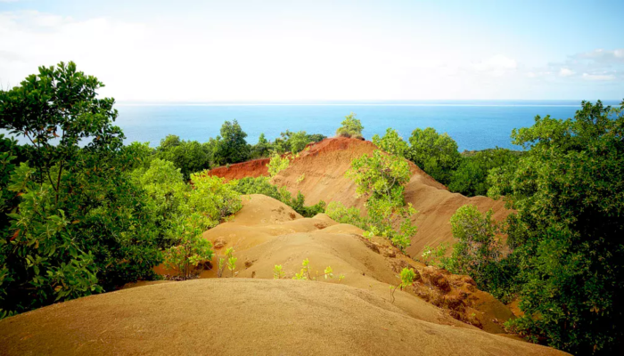
Mayotte, the so-called “perfume island”, is a volcanic island of the Comoros Archipelago and a French overseas department which hit the headlines in 2018-2019 with an enigmatic as well as frightening seismic swarm, recently linked to the appearance of a new submarine volcano nearby. Surrounded by one of the largest lagoons in the World and sprinkled with small islands, Mayotte only reaches 374 km2 above sea level for its 256000 inhabitants. This population is still increasing, leading to an anarchic and disordered land use and thus to an uncontrolled impact on the forest cover (e.g. the forest cover went from 65 % in 1987 to less than 20 % today according to the French national observatory of biodiversity). Because of the humid tropical climate of the region and the related annual strong rainfalls, the consequences of this deforestation are immediate, allowing the erosion to progress and the appearance of bad-lands called ‘padzas’. In 2008, the CIRAD identified 3000 hectares of padzas in Mayotte, circa 8% of the territory. These ocher coloured soils represent a wonderful opportunity for photographers because of the contrast with the neighbouring vegetation, but above all with the palette of blues of the lagoon. Some attempts to revegetate the padzas have been made a few years ago with the help of an Australian pioneer plant, the evergreen Acacia mangium, whose fallen leaves smooth the soil and stop natural revegetation of native plants.
I had discovered the problem of the padzas during a field trip about tsunamis in Mayotte in 2011 then more recently in 2017-2018 when I was teaching school kids north of Mamoudzou. Permitting these barren environments to last on such a small island will have disastrous consequences, resulting in erosion amplification and landslides. It is more than time to think of solutions to solve this problem and eliminate them, despite their attraction for tourists.
Description by Jean Roger.
If you pre-register for the 2020 General Assembly (Vienna, 3–8 May), you can take part in our annual photo competition! From 15 January until 15 February, every participant pre-registered for the General Assembly can submit up three original photos and one moving image related to the Earth, planetary, and space sciences in competition for free registration to next year’s General Assembly! These can include fantastic field photos, a stunning shot of your favourite thin section, what you’ve captured out on holiday or under the electron microscope – if it’s geoscientific, it fits the bill. Find out more about how to take part at http://imaggeo.egu.eu/photo-contest/information/.
Imaggeo is the EGU’s online open access geosciences image repository. All geoscientists (and others) can submit their photographs and videos to this repository and, since it is open access, these images can be used for free by scientists for their presentations or publications, by educators and the general public, and some images can even be used freely for commercial purposes. Photographers also retain full rights of use, as Imaggeo images are licensed and distributed by the EGU under a Creative Commons licence. Submit your photos at http://imaggeo.egu.eu/upload/.

