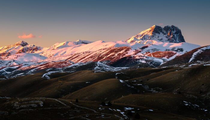
In the middle of the Apennines lays the Gran Sasso d’Italia mountain chain, a picturesque collection of mountains situated in the heart of Italy.
Featured here is one of the chain’s peaks, called the Corno Grande, meaning ‘Big Horn,’ coloured with a faint reddish light of a late-winter sunset. Sitting at 2,912 metres, this summit is easily the highest mountain in the Apennines.
The areas surrounding Corno Grande is enclosed in the Gran Sasso e Monti della Laga National Park, located in the hinterland of Italy’s Abruzzo region. The park, established in 1991, encompasses 2,015 square kilometres, making it one of the largest natural reserves in Europe.
Moreover, from an ecological standpoint, the region is one of the most biologically diverse areas in Europe, with more than 2,000 plant species, many of which can only be found in the park, and many rare animals.
The landscape that surrounds Corno Grande still shows traces of glacial erosion from the Quaternary Period, which began 2.6 million years ago. The region’s smooth highlands and U-shaped valleys are engravings of the slow glacial processes that occurred on these lands. The Corno Grande is even still host to a glacier today, as you can find the Calderone glacier, Western Europe’s southernmost glacier, beneath the mountain’s peak.
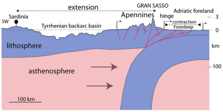
Sketch of the geodynamic setting of the Gran Sasso (Credit: Cardello and Doglioni, 2015)
The Apennine Mountains were built by a paradoxical geologic process, sometimes referred to as ‘syn-orogenic extension,’ where thickened crust spreads out while, at the same time, a belt of Earth’s crust is compressed, forming a chain of mountains. In the case of the Apennines, compression took place east of the range while extension occurred to the west.
“This synchronous processes of such different motions in the convergent belts is still an issue that must be unraveled for a better understanding of the mountain ridge formation,” said Alex Righetti, a PhD student studying marine geology at the Faculty of Sciences of the University of Lisbon, in Portugal, who captured this shot.
By Olivia Trani, EGU Communications Officer and Alex Righetti, FCUL
Imaggeo is the EGU’s online open access geosciences image repository. All geoscientists (and others) can submit their photographs and videos to this repository and, since it is open access, these images can be used for free by scientists for their presentations or publications, by educators and the general public, and some images can even be used freely for commercial purposes. Photographers also retain full rights of use, as Imaggeo images are licensed and distributed by the EGU under a Creative Commons licence. Submit your photos at http://imaggeo.egu.eu/upload/.