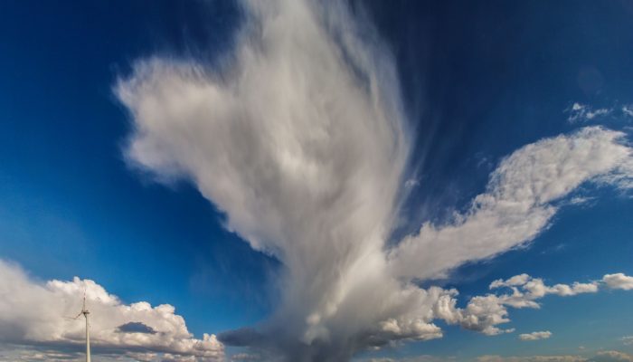
Clouds and storms are formed when warm, moist air rises. This causes the air to expand and cool: forming clouds as the moisture condenses onto particles suspended in the air (called cloud condensation nuclei). Normally, air rises from surface heating, or when warm and cold air pockets collide, or if air is pushed upwards when passing over hills or mountains. If this heating, and subsequent rising, is rapid enough then thunderstorms can form.
This imaggeo on Mondays photo shows an isolated thunderstorm roughly 50 km North of Vienna. The difference between an isolated thunderstorm and scattered storms is how much coverage the clouds have over a given area. If less than 10-20 % is covered then these storms are described as isolated. Scattered storms occur when coverage is at least 30-50 %. These storms can lead to downpours lasting a few minutes that then leads to sunny spells, only to have another rain storm occur again shortly afterwards.1
Globally, there are roughly 16 million thunderstorms each year, and at any given moment, there are ~2,000 thunderstorms in progress.2 The visible dark grey anvil shape and the fact that the lighter clouds above appear to be being ‘pulled into’ the storm suggests that this is a ‘severe’ thunderstorm. This means that the storm is self-supporting3 and can cause more extreme impacts than a normal thunderstorm. Rainfall is more intense and can cause flash flooding. In some cases, hail over 2.5 cm large can fall and tornados can even be formed.4 For more information about severe thunderstorms please check out the further reading list below.
By Sarah Connors, EGU Science Policy Officer
Further reading / sources
[1] – Aerostorms Scattered vs. Thunderstorms – http://www.aerostorms.com/scattered-vs-isolated-thunderstorms-what-is-the-difference/
[2] – Thunderstorm Basics – http://www.nssl.noaa.gov/education/svrwx101/thunderstorms/
[3] – Royal Meteorological Society Thunderclouds presentation – http://www.met.reading.ac.uk/~sgs02rpa/CONTED/WEATHER09_thunder.pdf
[4] – Frequently Asked Questions About Thunderstorms – http://www.nssl.noaa.gov/education/svrwx101/thunderstorms/faq/
Imaggeo is the EGU’s online open access geosciences image repository. All geoscientists (and others) can submit their photographs and videos to this repository and, since it is open access, these images can be used for free by scientists for their presentations or publications, by educators and the general public, and some images can even be used freely for commercial purposes. Photographers also retain full rights of use, as Imaggeo images are licensed and distributed by the EGU under a Creative Commons licence. Submit your photos at http://imaggeo.egu.eu/upload/.

Pingback: GeoLog | The best of Imaggeo in 2016: in pictures