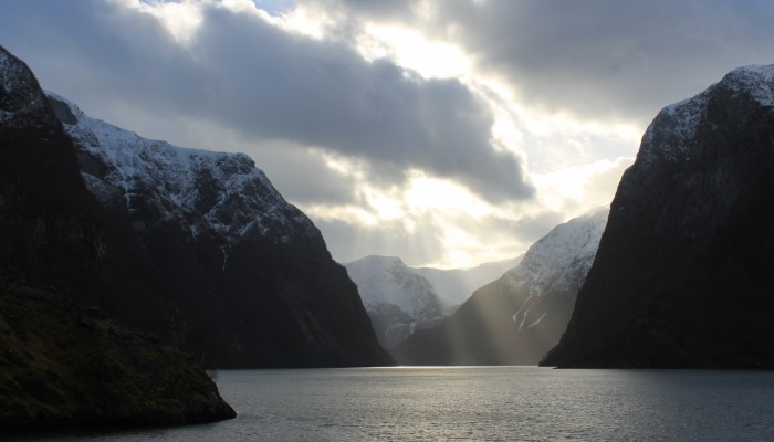
Feast your eyes on this Scandinavia scenic shot by Sarah Connors, the EGU Policy Fellow. While visiting Norway, Sarah, took a trip along the world famous fjords and was able to snap the epic beauty of this glacier shaped landscape. To find out more about how she captured the shot and the forces of nature which formed this region, be sure to delve into today’s Imaggeo on Mondays post.
The Nærøyfjord is situated in southern Norway between Oslo and the western of Bergen. It’s a narrow branch of the larger Sognefjord, which is the second longest and deepest fjord in the world (204 km long and 1,308 m deep). The 11 km Nærøyfjord is the world’s most narrow fjord spanning only 500 m at some points. It is also listed as a UNESCO World Heritage Site.
Fjords are formed by glaciers which have extended to below the present sea level. Glaciers are large ice structures that are slowly flowing due to their own weight. After periods of climate warming (i.e. after the last ice age) glaciers melt and expose deep valleys that have been carved from their movement. The increase in sea level from the melted glacier partially submerges the valley to form a fjord. In addition to this, the Earth’s crust can rebound due to the weight of the glacier being removed. The landscape that is created is therefore significantly different to what was there before.
In some fjords, after the glacier has retreated, the original river which created the glacier will return. This can allow for creation of homes and farming procedures along the fjord. The village of Gudvangen is found along the Nærøydalselvi river which flows into the inland tip of the Nærøyfjord.
The photo was taken just before sunset on a cold March day from a ferry that passes through the fjord daily. The cold spring time weather is highlighted from the snow, which can be seen on the peak tops. I was lucky and managed to capture the sunlight breaking through some low-lying clouds, which had made the day quite glum up until that point.
By Sarah Connors, EGU Policy Fellow.
Imaggeo is the EGU’s online open access geosciences image repository. All geoscientists (and others) can submit their photographs and videos to this repository and, since it is open access, these images can be used for free by scientists for their presentations or publications, by educators and the general public, and some images can even be used freely for commercial purposes. Photographers also retain full rights of use, as Imaggeo images are licensed and distributed by the EGU under a Creative Commons licence. Submit your photos at http://imaggeo.egu.eu/upload/


