Groundwater is easy to use but difficult to observe. Wells can measure local changes very precisely, but they are unevenly distributed, and long groundwater records are missing across large parts of the world.
Satellite gravimetry offers another view. Instead of measuring water levels in individual aquifers, satellites detect small changes in Earth’s gravity field caused by changes in mass. If a large region gains water, its mass increases slightly; if it dries, mass decreases.
The Gravity Recovery and Climate Experiment mission and its successor have provided these observations since 2002. We used 21.5 years of data, from April 2002 to September 2023, to examine groundwater change across the continents.
Satellites do not see groundwater directly
Gravity does not distinguish between groundwater and other forms of water. The satellite signal includes groundwater, soil moisture, snow, glaciers, lakes, rivers, reservoirs, and other surface water.
We therefore use the Global Gravity-based Groundwater Product. It starts with satellite-observed total water storage and removes estimated changes in root-zone soil moisture, snow, glaciers, and surface water. The remainder is an estimate of groundwater-storage change.
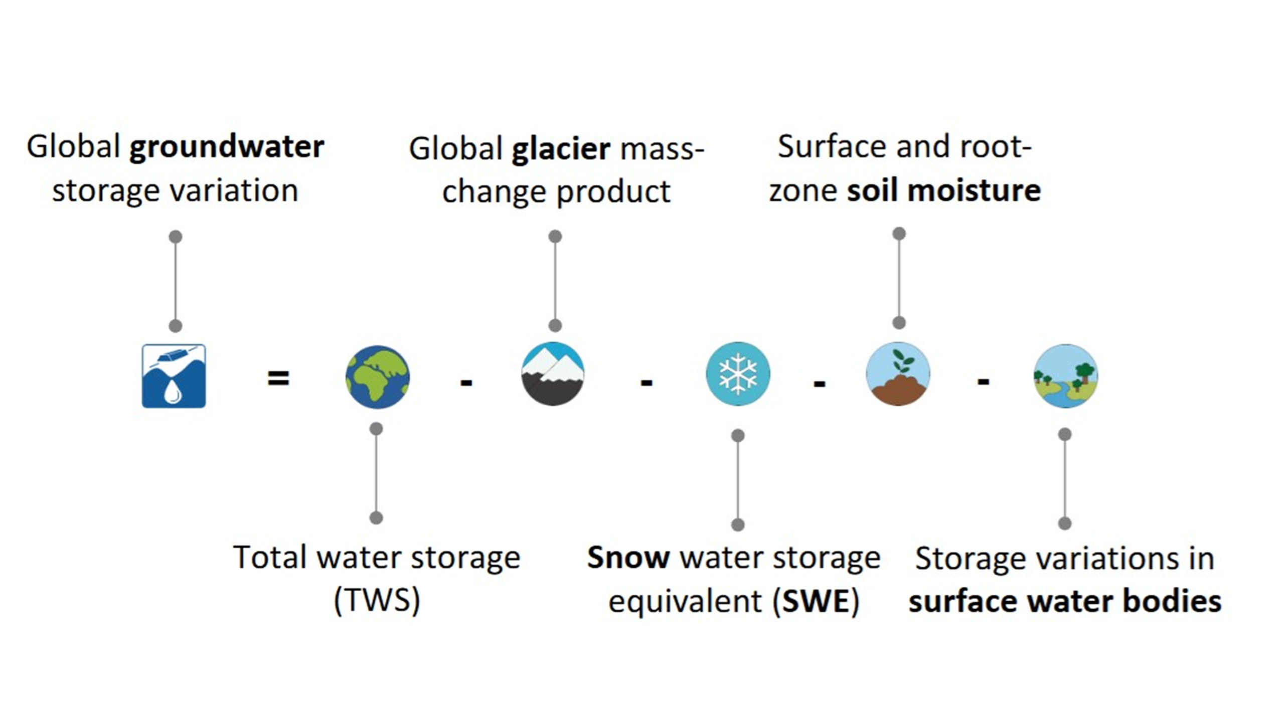
This provides a consistent view across regions where direct groundwater observations vary greatly in density and length.
Losing 103, gaining 77, ending at minus 27
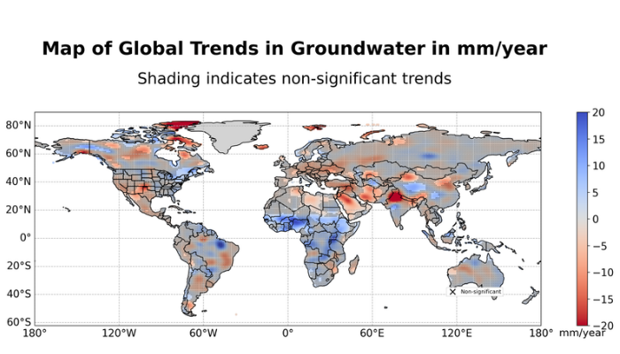
Across locations where we detect statistically significant groundwater trends, the combined loss is about 103 cubic kilometres per year.
Elsewhere, groundwater gains amount to about 77 cubic kilometres per year.
The resulting global net change is therefore about −27 cubic kilometres per year.
That difference matters. A global net loss of 27 cubic kilometres per year hides much larger regional changes. Groundwater gained in one region does not replace groundwater lost from an aquifer thousands of kilometres away.
Asia loses; large parts of Africa gain
Asia contains the largest continental groundwater loss in our analysis: about 55 cubic kilometres per year. Significant declines extend across Southwest and Central Asia, northern India, the North China Plain, and the Tarim Basin. Northern India contains some of the strongest local declines.
Africa shows a different pattern. Groundwater declines occur across northern Africa, including regions with large fossil groundwater systems. Farther south, storage increases over broad areas of the Sahel, the Niger Basin, and parts of central and eastern Africa.
Added across the continent, the significant trends give a net groundwater gain of about 37 cubic kilometres per year.
So the global picture is not a uniform decline. It is a patchwork of strong losses, substantial gains, and regions where no persistent trend can yet be separated confidently from the background variability.
Twenty years of change — or a sequence of wet and dry years?
Water storage can vary strongly over several years. Droughts persist. Groundwater retains the influence of earlier wet and dry periods. Climate variability can therefore produce apparent trends over records that are only a few decades long.
For each location, we estimated not only a linear trend, but also seasonal variations and the temporal correlation remaining in the time series. A trend is therefore harder to classify as significant where persistent variability is strong.
The same decline can be clearly detectable in one region and difficult to distinguish from natural variability in another.
The length of the satellite record helps. More than two decades of observations make it easier to separate persistent storage change from individual wet and dry periods.
Groundwater is only part of continental water loss
Some of the strongest declines in total continental water storage occur in glacierized regions, where ice loss rather than groundwater dominates the signal. Elsewhere, surface water, snow, or soil moisture can be important.
Groundwater is estimated after these components are removed, so errors in them can also enter the groundwater estimate. This matters particularly in the Arctic and in regions affected by glaciers, large lakes, reservoirs, permafrost, or uncertainty in corrections for the slow response of the solid Earth to past ice-sheet changes.
A statistically significant signal therefore does not automatically identify a unique groundwater process.
A global view, but not a single global story
Satellite gravimetry gives us something groundwater wells alone cannot: a spatially consistent view across most of the world’s continents.
The useful result is not just one global number. It is the geography behind it: where groundwater is being lost, where it is being gained, and where natural variability still prevents a clear long-term trend from emerging.