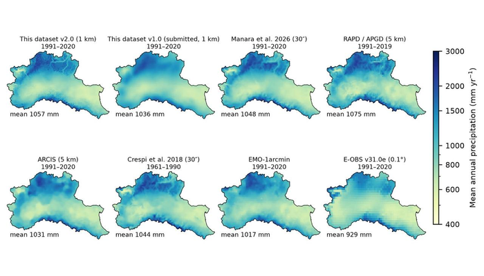
If you want to run a hydrological model anywhere, the first question is which meteorological forcing to use. For the Po basin, or anywhere in northern Italy, there are today at least a dozen gridded products, regional and European, built from different meteorological networks, with different methods and for different purposes. I reviewed them from one point of view: that of a hydrologist who needs daily forcing to close water budgets with a distributed model. The full review, with tables, station counts and references, is in my blog: Daily forcings datasets: rainfall and temperature in the Po River District. Here, I provide a summary.
What a forcing dataset must offer
For water budgets, I look for:
- a daily time step, with the day aligned to discharge records;
- precipitation and temperature from the same network and method, since rain–snow partition, melt and evapotranspiration depend on both;
- minimum and maximum temperature, for evapotranspiration and melt;
- a resolution close to the model units, about 1 km in Alpine sub-basins;
- coverage of the whole basin, headwaters from neighboring countries (Swiss and French for our case) included;
- an uncertainty for each cell and day;
- documented behaviour with elevation;
- open data and recent updates.
No product meets all of these.
The landscape
For northern Italy, the regional products come in four families.
- ARCIS, built by the regional meteorological services, covers precipitation from 1961 and minimum and maximum temperature from 1991, on a 5 km grid. It is homogenized and updated monthly.
- IH-GAR (Manara et al., 2026) gives precipitation at about 800 m from 1951 to 2023. It rests on the densest network and on elevation-aware monthly normals.
- APGD (Isotta et al., 2014) is the Alpine reference for daily precipitation, but it covers only the Alpine part of the basin and ends in 2019.
- The Crespi climatologies give precipitation normals for Italy (2018) and daily fields at 250 m for Trentino–South Tyrol (2021).
The European products (EMO-1 at about 1.5 km, E-OBS, the CERRA-Land reanalysis) are the most complete in variables and the most up to date. They have little direct Italian station input, however, and in the Alps EMO largely re-grids APGD. Two more pieces complete the picture: EEAR-Clim, a collection of about 9,000 quality-controlled Alpine station series, and ISPRA’s BIGBANG, a national monthly water balance at 1 km.
Count stations where you model
Station totals are misleading, because every product covers a different domain. What matters is how many stations support the meteorological field inside your basin, and how that number changes in time. Italian networks changed deeply around the year 2000, and the daily support of some products more than doubled within a few years. This affects spatial detail and, even more, trends, which need the homogenized series and controlled networks of ARCIS and IH-GAR.
A caution on daily fields built from monthly normals
Several of the best products build daily values by scaling station anomalies with elevation-aware monthly normals. This is excellent for climatology. But a normal is the number of wet days times their intensity, so the scaling can turn a higher frequency of rain at altitude into heavier storms. Monthly totals stay correct, while daily intensities may not. Before using such a product as daily forcing, check wet-day frequency and intensity at altitude, not only totals.
Which one, for what
- For climate analysis and trends: ARCIS and IH-GAR.
- For precipitation totals in Alpine basins: IH-GAR, or APGD up to 2019.
- For operational monitoring: ARCIS.
- For daily forcing of a distributed hydrological model: EMO-1 if you need many variables and recent years. A regional product built from one network is the alternative if you want precipitation and temperature together with their uncertainty.
Whatever the choice, compare totals at altitude with at least one other product.
What is still missing
The weakest point is shared by almost all regional grids: the input station series are not released, because they belong to the regional services. Without them, every dataset is a black box that can only be compared with other black boxes; EEAR-Clim shows that another way is possible.
In addition, the interpolation code is rarely open. Daily fields built from monthly components are seldom validated at the daily scale. And precipitation at high elevation still lacks independent checks: snow undercatch, shared by all gauges, can only be revealed by closing water budgets on gauged basins.
A disclosure: with Hossein Salehi and colleagues, we have a dataset of our own in the review, a 1 km daily product built by kriging in GEOframe and now in open discussion at ESSD. I tried to judge it with the same yardstick as the others; its limits are listed in the full post. Its review was useful and sometimes hard, and several of the points above came from it. That is what open discussion is for.
Edited by B. Schaefli