The research gap
Ocean tides play a significant role on ocean circulation, coastal processes and mass variations. Tides are generated from the gravitational interaction between Earth, Moon and Sun, which typically results in two high and two low tides observed each day. Satellite observations have vastly expanded our understanding of ocean tides. In 2022, the Surface Water and Ocean Topography (SWOT) satellite was launched, funded by CNES and NASA, and provided a new perspective on the ocean surface and inland water systems. The unique of SWOT comes from its ability to observe the ocean from a two-dimensional perspective, allowing for fine-scale variability of the ocean surface and the observation of process across the land-ocean zone. For more information of SWOT, please visit: https://swot.jpl.nasa.gov/.
Early research has been extremely positive and promising, but a clear avenue of research has opened up about exploring the capabilities of these new measurements to study processes at the interface of oceanography and hydrology. One such process is the aforementioned ocean tides, particularly in the challenging river and estuary regions. Historically, observations of tides within coastal rivers have been limited to tide gauges, which are sparsely distributed.
The findings
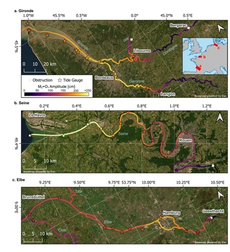
Figure 1. Tidal amplitudes within three selected river networks estimated from SWOT measurements. Courtesy of Michael Hart-Davis, based on article “Observing the tidal pulse of rivers from wide-swath satellite altimetry”, published in Nature.
With SWOT, specifically the River products (RiverSP), we analysed every observed coastal river and estimated components of the ocean tide, and derived an algorithm to estimate the tidal extent. In Figure 1, we show the estimation of the amplitude of the main lunar component of the tide in three select rivers. This finding in itself is novel, as we have never had such a clear picture of the tidal heights within rivers before. In the global dataset, which is also seen in the select rivers, we observed interesting differences between rivers, with the tide sometimes getting larger in a river and sometimes getting smaller upstream. The ability to derive such key information means we can start to evaluate the impact of extreme events, induced by compound flooding (tides + storm surges), on a river system. In our manuscript, we investigated this within the Congo River system.
The main finding of our manuscript is shown in Figure 2, which presents the first global atlas of tidal extent. The method to do this is described in our manuscript, but to summarize, this is done by combining several factors, including tidal heights and river dynamics. We were able to see regions of vast tidal extent, for example the Amazon river where the tide can propagate 100s of kilometers upstream.
Using these findings, we can start to evaluate the influence tides have on the human population. We discover that 715 million people live within 10 km of a tidal river. Furthermore, we determine that over 110,000 km2 of agriculture land lies within 3 km of a tidally influenced river.
This research has wide-ranging implications across cross-disciplinary science, as well as down to local communities and municipalities. The downstream applications of this will be the improved understanding of crucial processes, such as compound flooding, sea level variability, and saltwater intrusion. Furthermore, improvements to tide models in the coastal zone will affect not only oceanographic and hydrological applications but also geodetic applications, particularly satellite altimetry.
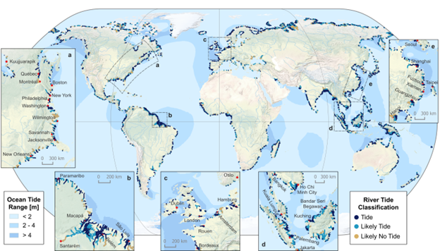
Figure 2. Global river tide classification atlas with detailed inset maps of select coastal areas. Courtesy of Michael Hart-Davis, based on article “Observing the tidal pulse of rivers from wide-swath satellite altimetry”, published in Nature.
Looking ahead
This manuscript opens the door for a wide range of cross-disciplinary research across the land-ocean continuum. With the continued flying of the SWOT satellite as well as similar planned future missions, this research will continue to grow into studying the fine-scale spatial variability of ocean tides and their interaction with hydrological processes, such as river discharge.
Interactive Map: https://dahiti.dgfi.tum.de/en/products/river-tides/map/
Edited by Marius Schlaak
Reference

Hart-Davis M.G., Scherer D., Schwatke C., Sawyer A., Pavelsky T., Ray R.D., Matte P., Dettmering D, Seitz F. 2026. Observing the tidal pulse of rivers from wide-swath satellite altimetry. Nature. https://doi.org/10.1038/s41586-026-10287-z.