

You are observing the construction of a bridge that will be initiated on the two banks of a river simultaneously, in such a way that the works will eventually meet in the middle of the river. You wonder, how do they make sure that the construction on the two sides will stay aligned with the millimeter precision that this project requires? You are aware of previous constructions where small miscalculations led to embarrassing results, such as the Laufenburg bridge between Germany and Switzerland (2003) [1] or the Gokhale Bridge in Andheri, Mumbai (India, 2024) [2]. In your case, you fully trust the construction team’s skills and are sure all the distances have been double-checked.
However, a question may still bother you. All construction distances are computed with respect to fixed points with known coordinates on each bank of the river, which were previously aligned. But what if the ground has moved since then, causing misalignment in the reference points and, therefore, in the whole construction? In other words, how do we ensure a robust and well-known physical reference for the construction?
If you had a geodesist friend by your side, they would probably explain to you that this difficult task is achieved through geodetic reference frames, which consist of a set of physical points (reference stations) with precisely determined coordinates and velocities. To be reliable, these reference frames must account for the invisible, continuous change on and beneath the Earth’s surface. In this blog post, we will explore the drivers that change the shape of the Earth, how a reference frame can account for these changes, and the role of regional reference frames in monitoring changes on regional levels.
Why does the Earth’s surface constantly deform, and how can it be monitored?
Earth is a complicated structure and nothing like the perfect blue sphere we see in photographs from space. That image is beautiful, but misleading. The Earth is commonly approximated by a reference ellipsoid (Fig. 1), which
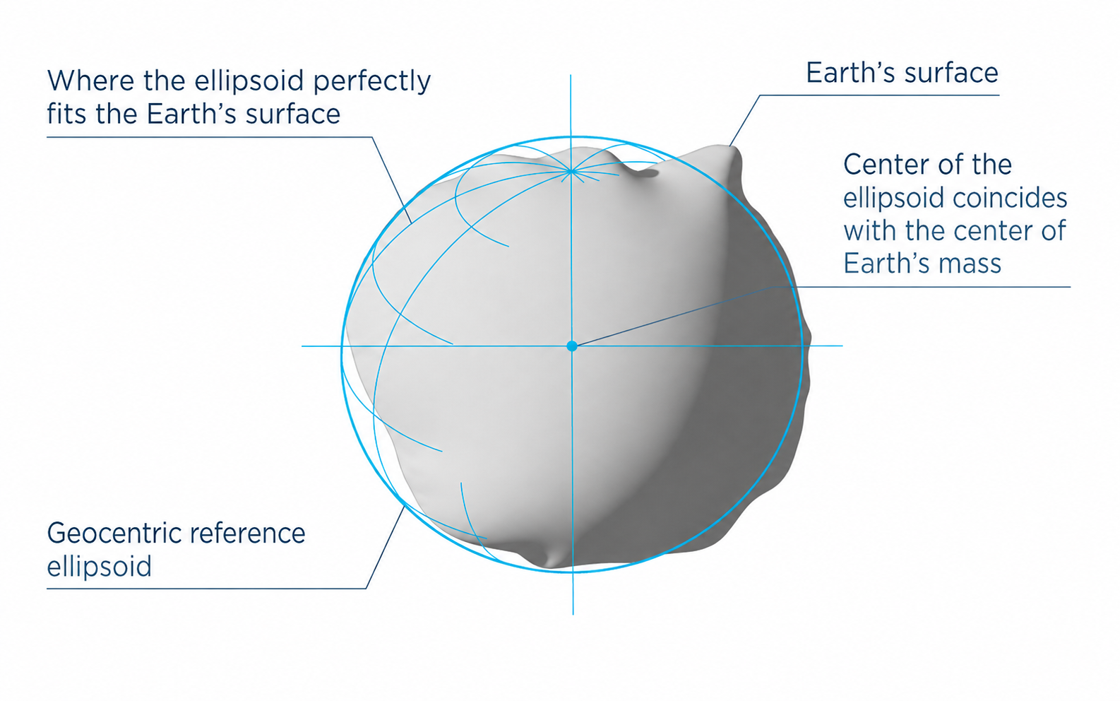
Fig 1. Schematic representation of the geocentric reference ellipsoid fitted to the Earth’s surface, with its center coinciding with the Earth’s center of mass. (Credit: Emlid)
provides the mathematical foundation for modern geometric reference frames such as the International Terrestrial Reference System (ITRS). Although convenient for positioning, this idealized surface does not fully represent Earth’s complex gravity field or topography. Underneath, the crust is broken into massive slabs called tectonic plates, which drift and collide at 2 to 10 centimetres per year. Where they meet, mountains rise, or where they pull apart, new ocean floors are born. Additional geophysical processes such as melting ice caps, seismic activity or natural hazards can also modify the shape of the Earth at different scales. The ground is never truly still, and, even a perfect coordinate measured today will be slightly wrong tomorrow.
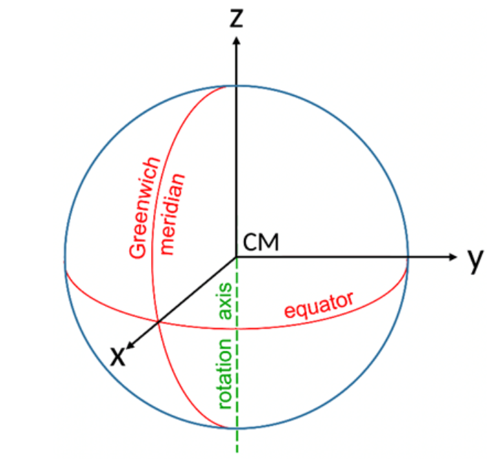
Fig 2: The International Terrestrial Reference System. CM represents the centre of mass. (Credit: Alexander Kehm)
This complicated problem can only be solved by having precise 3D coordinates at every point on the surface of the earth to track all these dynamic changes. The International Terrestrial Reference Frame (ITRF) aims to achieve a “near-perfect” global description of these changes, by computing the X, Y, and Z coordinates of diverse points on Earth with respect to the center of mass (CM) of the Earth as the origin. The axes form a right-angled triad, with the X and Y axes lying in the equatorial plane, while the Z-axis points towards the North Pole (Fig. 2). In practice, the frame is realized using a global set of ground stations that incorporate information on the Earth deformation. The coordinates of a point obtained at any instant (epoch) using such a global frame are also accompanied by velocities to compensate for dynamic changes due to plate movements. More details on the global reference frame are available in this previous post.
Why do regional frames exist when a global one already does?
If ITRF provides a near-perfect global solution, one might reasonably ask: why do regional frames need to exist? Well, there is a high likelihood that global changes don’t reflect those within a particular region. Consider the example of India: out of a total of 1344 Global Navigation Satellite System (GNSS) stations, only three Indian GNSS stations were used to realise the ITRF2020 reference frame. Considering north-eastern India is a highly seismically active region, the limited number of stations is inadequate to represent regional variations. Thus, a regional reference frame is tailored to the region of interest, with a dense network of ground stations to better capture local phenomena that might have been ignored by the global best-fitting solution. The International Association of Geodesy (IAG) organizes regional frames into six sub-commissions: EUREF (Europe), SIRGAS (South America), NAREF (North America), AFREF (Africa), APREF (Asia-Pacific), and SCAR (Antarctica). Several countries have also developed national frameworks to monitor such activities, and the coordinates may or may not be shared beyond their borders. There might be a chance that coordinates from two different networks can be off by a few centimeters to several meters based on their frame realization strategies. Conventionally, these regional and national frames are mathematically aligned with the ITRF to ensure interoperability in positioning and location.
Applications of global and regional reference frames
A robust reference frame is essential to support not only construction works, but also a variety of day-to-day activities, ranging from self-driving cars and infrastructure monitoring to boundary mapping and aircraft and missile guidance systems. The applications extend to understanding the dynamics of our planet Earth caused by a variety of geophysical phenomena.
Any coordinates without the frame, epoch, and station velocity are meaningless and are just random numbers. As the ground keeps moving, these frames keep the world from drifting apart. A regional reference frame offers a sentinel’s view of a restless planet with rigorously tracking every subtle change, so that what begins as a millimetre of drift never silently grows into a catastrophe.
References and further reading

1. Marine Digital. (n.d.). Measure twice and cut once or how the sea level prevented the construction of the bridge. Retrieved June 1, 2026, from https://marine-digital.com/article_bridge_between_germany_and_switzerland

2. Urban Acres. (2024, April 20). BMC to investigate Gokhale Bridge Barfiwala Flyover alignment error. https://urbanacres.in/bmc-to-investigate-gokhale-bridge-barfiwala-flyover-alignment-error-urban-acres/

3. Altamimi, Z., Rebischung, P., Collilieux, X., Métivier, L., & Chanard, K. (2023). ITRF2020: An augmented reference frame refining the modeling of nonlinear station motions. Journal of Geodesy, 97, 47. https://doi.org/10.1007/s00190-023-01738-w

4. Sánchez, L., Drewes, H., Kehm, A., & Seitz, M. (2022). SIRGAS reference frame analysis at DGFI–TUM. Journal of Geodetic Science, 12(1), 92–119. https://doi.org/10.1515/jogs-2022-0138
– Edited by: Leire Retegui-Schiettekatte
– Use of AI: LLMs have been used to improve language and clarity of specific parts of the text