What if we brought all four major space-geodetic techniques together on a single spacecraft for the first time? ESA’s Genesis mission, expected to launch in 2028, will do just that, combining Global Navigation Satellite System (GNSS), Satellite Laser Ranging (SLR), DORIS and Very Long Baseline Interferometry (VLBI) on one carefully calibrated platform. Well before launch, scientists are investigating how this unprecedented configuration could strengthen the terrestrial reference frame and improve our understanding of the changing Earth.
Why Genesis is more than another satellite
Every satellite image, navigation position and observation of environmental change, from sea-level rise to ice-sheet loss, rests on a quiet assumption: that we understand how Earth behaves over time, including its position and orientation in space, its changing shape and surface, and the evolution of its gravity and magnetic fields. In geodesy this assumption is turned into a number of products, one of those is the International Terrestrial Reference Frame (ITRF). It is not a map in the everyday sense, but the coordinate backbone behind maps, satellite orbits, climate records and many Earth-observation products.
The challenge is that Earth is not a rigid object. Continents drift, ice sheets lose mass, groundwater and ocean loading deform the crust, and the rotation axis slowly wanders. To compare today’s measurements with those made years from now, we therefore need a reference frame that is both accurate and stable. The scientific target often quoted for future reference frames is demanding: about 1 mm in position and 0.1 mm per year in long-term stability (Delva et al., 2023). Why does this matter? Many changes we want to monitor – from sea-level rise to ice loss and slow movements of the Earth’s crust – occur at only a few millimeters per year, so the reference frame itself must remain substantially more stable than the signals we are trying to measure.
No single observing technique can realize this reference frame alone. Modern geodesy relies on four complementary techniques: GNSS provides continuous positioning observations from a dense global network; SLR helps determine the frame’s origin and scale through precise laser distance measurements; DORIS contributes independent satellite tracking using ground-based radio beacons; and VLBI connects terrestrial measurements to distant quasars, establishing Earth’s orientation in space. Combining these techniques allows scientists to benefit from their complementary strengths. Genesis is unprecedented because it brings all four space-geodetic techniques together on a single dedicated platform, but the idea of space co-location itself does have heritage. GNSS, SLR and DORIS have already flown together on missions such as Jason-2 and Sentinel-6, where they have been used jointly for precise orbit determination and cross-validation. Genesis is different because the spacecraft, instrumentation, calibration, geometry and processing strategy can all be designed specifically around the goal of linking the techniques as accurately as possible.
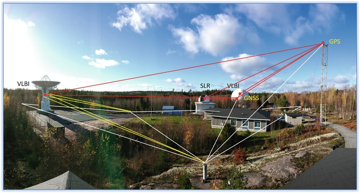
Fig 1: The local tie network (red), part of the local survey network (white), and part of the monitoring network (yellow) in Metsähovi from Kallio et al. (2023)
Today, the techniques are usually connected at ground observatories by local ties: carefully surveyed distances between instruments such as a GNSS antenna, an SLR telescope and a VLBI radio telescope (see Figure 1). The challenge is not only to measure the distances between the instruments, but also to know exactly how their reference points are connected and to keep these links stable at the millimeter level over time.
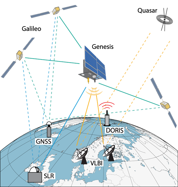
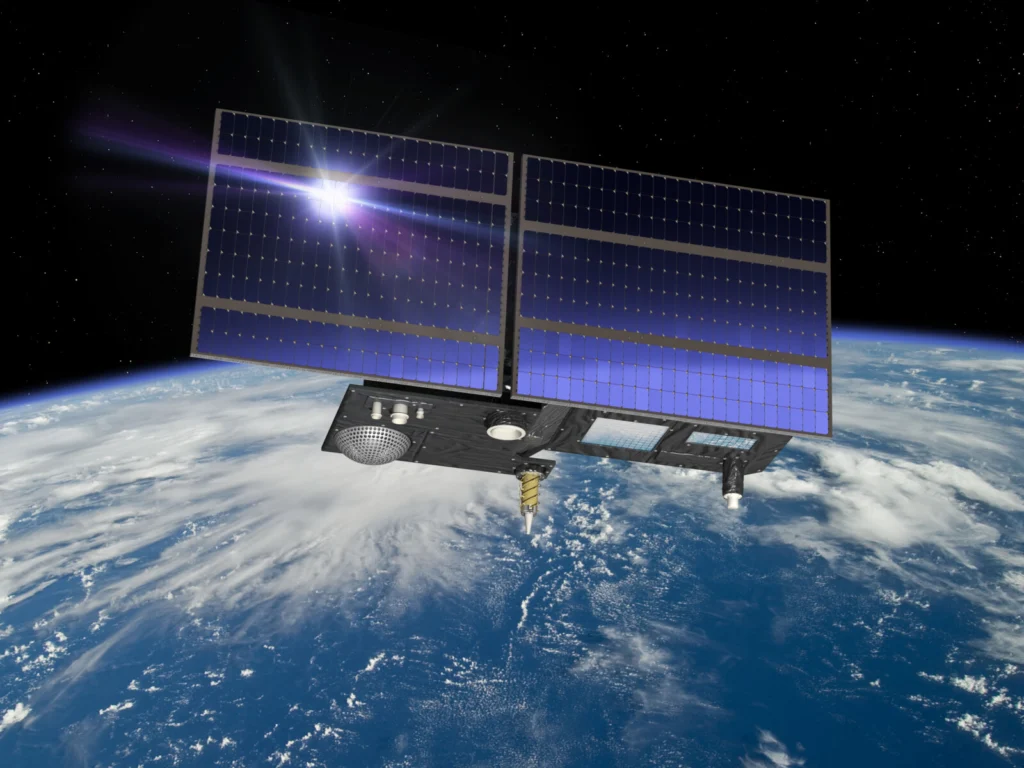
Fig 2: Co-location of geodetic techniques on board Genesis (Credits: H. Wolf).
Genesis changes the geometry of the problem, (Figure 2) so that the comparison point is moved from the ground into orbit (Delva et al., 2023). This does not make the ground networks less important. Genesis’ value is more subtle: it should help those networks speak a more consistent language. It gives them an additional, well-characterized target through which their measurements can be tested against one another. If successful, the benefits will appear in products that many users never associate with geodesy: sea-level estimates, ice-mass monitoring, natural-hazard studies, gravity-field modelling, satellite orbit determination and high-accuracy navigation. This matters because the global geodesy supply chain is a public-good infrastructure: invisible to most users, but fundamental to Earth science.
GNSS: Genesis strengthening the space-Earth connection
Genesis has a clear mission goal, but its scientific value will depend on how well observations from the different techniques can be combined in practice. For Genesis, precise orbit is essential, as it provides the common trajectory for linking all onboard observations. Genesis will carry two GNSS antennas, looking in different directions: one toward Earth and one away from it. This dual-antenna concept is particularly important because Genesis will orbit at about 6000 km, higher than typical 400-1400 km low-Earth-orbit geodetic and remote-sensing missions. While LEO satellites commonly rely on a zenith-looking GNSS antenna because the GNSS constellations are far above them, Genesis will operate closer to the GNSS orbital region, where useful signals can arrive from both the zenith and nadir directions. Two oppositely oriented antennas enlarge the usable tracking geometry, improve the continuity of observations and make the orbit solution less dependent on a single viewing direction (Kur et al., 2024). They help tie the Genesis orbit to the onboard instruments, the satellite clock and the terrestrial reference frame. This matters for the whole mission: a better known orbit makes it easier to compare GNSS, SLR, DORIS and VLBI on one platform, and to distinguish real geophysical signals from small instrumental or modelling biases.
SLR: giving Genesis a precise link to Earth
Unlike GNSS, where a receiver can continuously track signals from many satellites at the same time, an SLR station measures one satellite at a time by sending short laser pulses and timing their return. The strength of SLR therefore comes from combining observations to satellites with different orbital characteristics and viewing geometries. The central question is how Genesis could strengthen products derived from combinations with established laser-ranging satellites such as LAGEOS and LARES, rather than being treated as an isolated spacecraft. Genesis does not replace these satellites; instead, its different orbit adds a new piece of geometry to the existing SLR constellation, helping to make the combined solution more robust and sensitive to parameters that benefit from a diverse set of satellite orbits. (Kur et al., 2025). SLR is especially important because it links the origin and scale of the terrestrial reference frame to the center of mass of the whole Earth system. If we place the origin of our reference frame in the wrong place, part of that error can be mistaken for a real change in the Earth system, for example, a change in ice mass or sea level.
VLBI: the missing target in the sky
VLBI observations to satellites are the missing link in space geodesy. To understand why this matters, we first have to look at how we usually track satellites. Currently, we rely on methods like GNSS or SLR. These are excellent tools, but they are “Earth-centric”: they determine where a satellite is relative to Earth, but cannot directly relate its orbit to a fixed reference beyond Earth. VLBI offers a different approach by simultaneously observing the satellite and extremely distant, bright radio sources located far outside our galaxy (extragalactic sources). Because these sources are so far away, they are essentially fixed points in the sky. This allows scientists to determine the satellite’s orbit relative to the stars and establish a direct connection to the celestial reference frame.
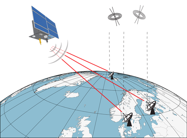
Fig 3: Genesis – the first satellite with VLBI transmitter (Credits: H. Wolf)
However, this isn’t easy. A major challenge is the satellite’s signal itself. Unlike a quasar, which produces a naturally occurring and typically very weak radio signal, a satellite transmits an artificial signal generated by its onboard equipment. Additionally, the satellite is constantly moving, making it more difficult to accurately detect and track its signal (Wolf et al., 2026). Despite these hurdles, the Genesis mission represents a giant leap forward, turning a satellite into a bridge between our planet and the deep cosmos. The experience gained from Genesis could also pave the way for future developments in space-based geodesy and navigation
DORIS: an independent link to the terrestrial network
DORIS adds an important and largely independent element to this concept. Unlike GNSS, where the spacecraft receives signals from navigation satellites, DORIS uses signals transmitted by a global network of ground beacons and derives precise tracking information from Doppler measurements. It therefore provides an additional source of precise orbit information with a different observation geometry and different instrumental characteristics. In this way, DORIS contributes to the determination and validation of the Genesis orbit, and strengthens the central co-location objective.
A Quiet Revolution in Space Geodesy
Among the hundreds of satellites launched every year, it would be easy to overlook one that has excited the geodetic community perhaps more than most. Genesis is not designed to deliver a spectacular image or a single headline result. Its ambition is quieter but more fundamental: to help provide something that the whole of Earth science silently relies on geodesy to deliver: a stable, accurate and consistently realized reference frame. Will Genesis solve all the remaining challenges? Certainly not. But by bringing the major geodetic techniques together on one carefully calibrated platform, it could take us an important step closer to the reference frame that observing our changing planet increasingly demands.
~ Edited by: Radoslaw Zajdel
~ Use of AI: LLMs have been used to improve language and clarity of specific parts of the text
References and further reading

1. Delva, P., Altamimi, Z., Blazquez, A., et al. (2023). GENESIS: co-location of geodetic techniques in space. Earth, Planets and Space, 75, 5. https://doi.org/10.1186/s40623-022-01752-w
2. Kallio, U., Klügel, T., Marila, S., Mähler, S., Poutanen, M., Saari, T., Schüler, T., & Suurmäki, H. (2023). Datum Problem Handling in Local Tie Surveys at Wettzell and Metsähovi. In J. T. Freymueller & L. Sánchez (Eds.), Geodesy for a Sustainable Earth (pp. 45–55). Springer International Publishing. https://doi.org/10.1007/1345_2022_155
3. Kur, T., Sośnica, K., & Kalarus, M. (2024). Prospects of GENESIS and Galileo joint orbit and clock determination. Journal of Geodesy, 98, 51. https://doi.org/10.1007/s00190-024-01869-8
4. Kur, T., Najder, J., & Sośnica, K. (2025). Genesis contribution to SLR-based geodetic parameters. Journal of Geodesy, 99, 87. https://doi.org/10.1007/s00190-025-02007-8
5. Wolf, H., Kern, L. M., Steinmetz, S., & Böhm, J. (2026). Deriving a TRF from VLBI Observations to Genesis: What Is the Impact of the Inclination? In International Association of Geodesy Symposia (pp. 1–8). Springer. https://doi.org/10.1007/1345_2026_346
6. Wolf, H., Jaron, F., & Böhm, J. (2026). On the impact of imperfect models for multiple VLBI antennas on the Genesis satellite on the terrestrial reference frame. In EGU General Assembly 2026. EGU General Assembly 2026, Wien, Austria. https://doi.org/10.5194/egusphere-egu26-7611
7. Wolf, H., Kern L. & Böhm, J. (2026) Simulation of errors with the VLBI transmitter on Genesis and their impact on the terrestrial reference frame. Submitted to Journal of Geodesy
8. European Space Agency (2026). ESA’S Genesis Mission – Preliminary Baseline Overview. https://doi.org/10.57780/esa-6fhsptj