Why? When a river freezes over, it changes the amount of water that flows through the river system. River ice affects many of the world’s largest rivers, and in the Northern Hemisphere, approximately 60% of rivers experience significant seasonal effects. The formation and evolution of river ice changes river discharge and is not only of interest to local ice skating enthusiasts. The variations in ...[Read More]
Image of the Week – Monitoring icy rivers from space!
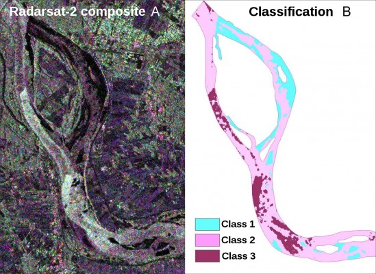
River-ice cover on the Vistula (Poland) classified from Satellite SAR data. (A – left) River ice cover on Vistula River on 28th January, 2015 (RADARSAT-2, RGB: HH HV VV). (B – right) Ice cover classification based on RADARSAT-2 data. 'Class 1' - smooth ice cover without ice dam underneath (black ice); 'Class 2' - ice cover with loosely agglomerated mobile ice; 'Class 3' - ice cover with consolidated mobile ice, see text for explanation [Credit: Helena Łoś]