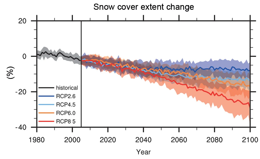
Who is dreaming of a white spring? In daily life we might be more interested in the chances of a white Christmas, but the amount of snow-covered ground in the spring is a very good indicator of climate change. The figure above shows the projected change in snow cover extent in the Northern hemisphere in March-April …[Read More]
Cryospheric Sciences
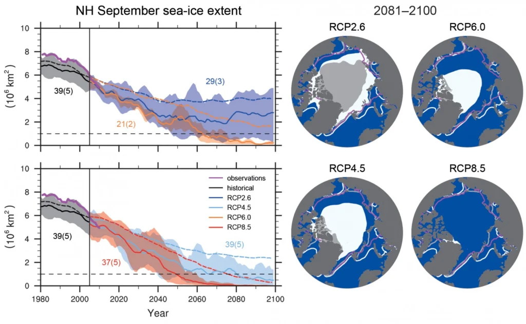
Image of the Week — Future Decline of sea-ice extent in the Arctic (from IPCC)
The Arctic sea-ice extent has declined in the past 20 years and its future is uncertain. In the end, greenhouse gas emissions will determine the impact on the sea-ice from man-made climate change through radiative forcing (i.e. Representative Concentration Pathways or RCPs). The COP21 can determine the path we will follow and which course we will take to …[Read More]
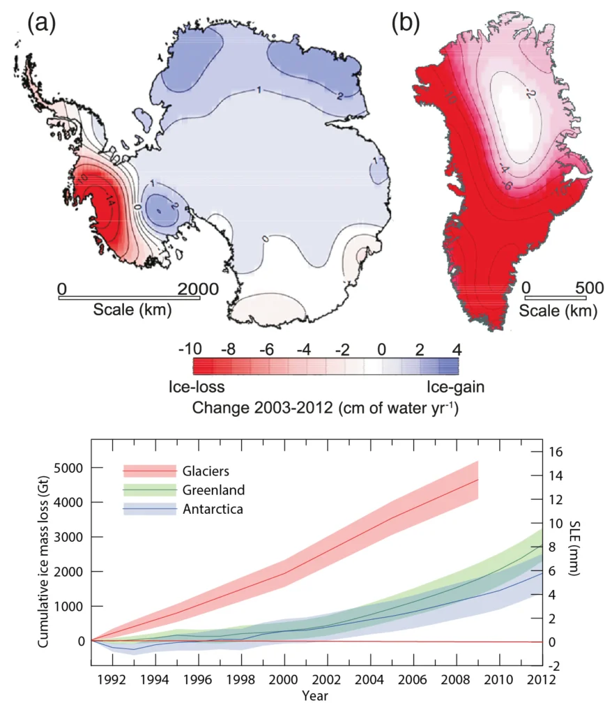
Image of the Week — Ice Sheets and Sea Level Rise (from IPCC)
Context On the eve of the COP21, it is of paramount importance to recall how strongly the cryosphere is affected by Climate Change. Today, we present the impact of melting ice on sea level rise, as it is presented in the latest assessment report of the Intergovernmental Panel on Climate Change. Quick facts -Since 1992, …[Read More]
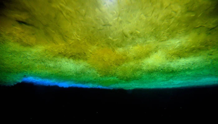
Image of the Week: Under the Sea
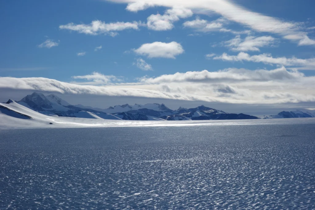
Always wondered how it looks like under the sea ice? Getting an answer is simpler than you might think: Just go out to the front of McMurdo ice shelf in Antarctica and drill a tube into the sea ice. Then let people climb down and take pictures of the ice from below. More information: – …[Read More]
Image of the Week — What’s up with the sea-ice leads?
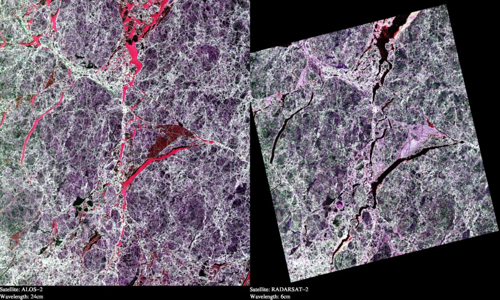
This illustration shows two Synthetic Aperture Radar (SAR) images taken over sea ice in the Arctic Ocean. Both images are polarimetric and the different colours reflect the different polarimetric channels of the SAR (red = VV, green = HV and blue = HH). The two images are from the two satellites “ALOS-2” and “RADARSAT-2”. These …[Read More]
Sunshine, ice cores, buckets and ALE: Antarctic Fieldwork
My Antarctic adventure started from Punta Arenas at the bottom of Chile, opposite Tierra del Fuego, on New Years Eve 2014 after a long journey from Heathrow via São Paulo and Santiago. Punta Arenas Punta Arenas is where Shackleton organised the rescue of his men from Elephant Island after his voyage to South Georgia in …[Read More]
Image of the Week: Greenland Glacier Seen from a Drone
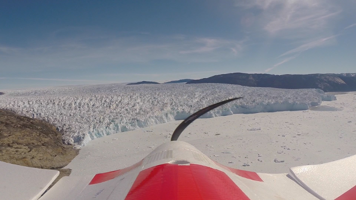
The use of drones or Unmanned Aerial Vehicles (UAVs) is one of the most exciting development in glaciology in recent years. The picture was taken during fieldwork conducted in the summer of 2014 by Johnny Ryan and colleague Nick Toberg. The aim was to survey Store Glacier once a day using a fixed-wing UAV, that was equipped with …[Read More]
Image of the Week : 63 years of the Muir Glacier’s retreat
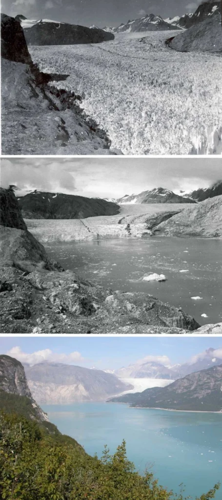
The Muir is a valley glacier (Alaska) that has significantly retreated over the last 2 centuries. The 3 pictures have the same field of view and record the changes that occurred during the 63 years separating 1941 and 2004. In the 1941, the terminus of the glacier is on the lower right corner of the …[Read More]
Filling the Gap between Science and Politics
Have you ever wondered how results from scientific studies make their way into policy and influence government decisions? Read about the experiences of Sammie Buzzard, University of Reading, who spent her summer working for a government body in Westminster, London, UK. This summer I had the opportunity to take some time away from my usual …[Read More]
Image of Week: Inside the Greenland Ice Sheet
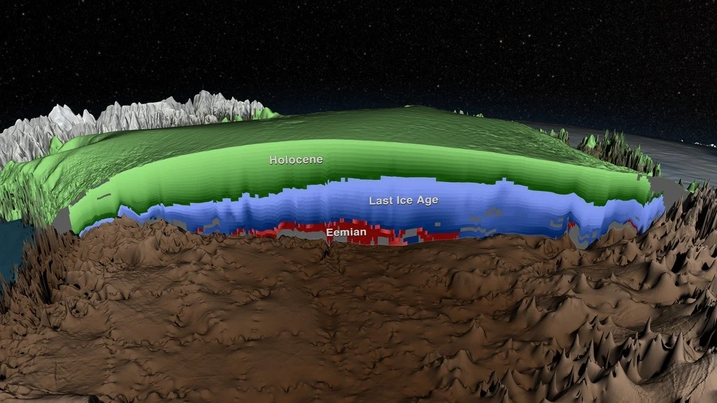
The image shows a cross section of the Greenland Ice Sheet, where a recent study by MacGregor et al. have mapped the layers imaged by radar. Thanks to ice core measurements the age of the layers have been determined, and in the image the layers from the Holocene period (the past 11.700 years) are shown in green. …[Read More]