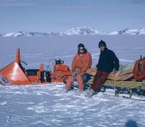
Kggk kggk kggk – the sound of crampons accompanies me. A thin layer of snow covers the slippery ice while I pull a sled. As I wipe my hand over the snow, underneath, a blue color glitters in the sun (Figure 2). In the last days it has been snowing in the White Desert (Antarctica). All blue ice we could see before is temporarily covered by a thin blanket, perfect to pull a sled. However, this snow on blue ice also poses challenges – not in the pleasant sun on that day in the field, but behind my computer in Belgium. Later in the blogpost I will explain how we address these challenges in my recent publication (Tollenaar et al., 2024), but first things first: what is blue ice and why are scientists interested in it?
Antarctic blue ice areas
In blue ice areas, deep layers of ice are exposed directly at the surface. The ice at the surface obtains a typical light-blue color, which can be also seen in crevasses on mountain glaciers. In total, blue ice areas cover approximately 1% of the surface of Antarctica. The extent of individual blue ice areas ranges from under a square kilometer to over 1,000 km2.
Since the serendipitous recovery of nine meteorites from blue ice in the Yamato mountains in 1969, blue ice areas are frequented to search for meteorites. These searches are generally successful, as a concentrating mechanism brings meteorites to the surface. This mechanism relates to the flow of the ice, meteorological factors, and the long exposure of the surface. The latter implies that the ice at the surface (and hence the ice below the surface) can be very old. Recent advances in laboratory analyses allow to estimate the absolute age of the ice and interpret the disturbed flow patterns of blue ice. These advances helped to recover samples of up to 6 million years old by the COLDEX team.
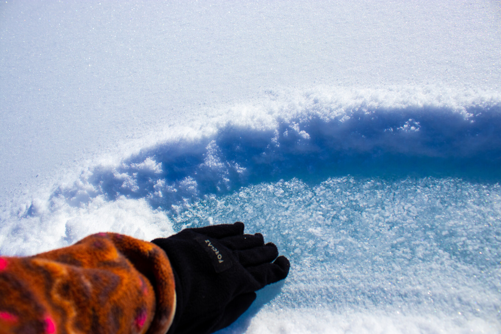
Figure 2: Blue ice under a thin temporary snow cover. Photo taken during the 2023-2024 fieldwork mission of the Instituto Antártico Chileno (INACH) to Union Glacier, Ellsworth Mountains, Antarctica. Credit: Veronica Tollenaar, Université libre de Bruxelles.
Observing blue ice
By eye, it is easy to identify patches of blue ice, both in the field, but also on satellite images. Blue ice is typically found towards the margins of the continent, in mountainous regions, and their shade of blue contrasts clearly with the omnipresent white snow. However, there are multiple challenges in automatizing the identification of blue ice. To overcome these, deep learning (a type of machine learning) is a good tool.
First, blue ice is typically identified by its contrast to surrounding regions, making spatial context essential for its identification. In deep learning this context can be considered in a quite unique way by using something called convolutions- (which are mathematical operations somewhat similar to kind of filtering operations). The subset of deep learning algorithms that uses these convolutions are called convolutional neural networks.
Secondly, temporary snow cover hampers the detection of blue ice on visual imagery. This risk can be reduced by using multiple observations over a longer time, but also by using satellite radar, which can penetrate shallow snow cover. However, radar signals are influenced by various processes, making it hard to detect blue ice based solely on radar data. Deep learning can efficiently combine both types of observations.
How to use a blue ice map
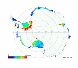
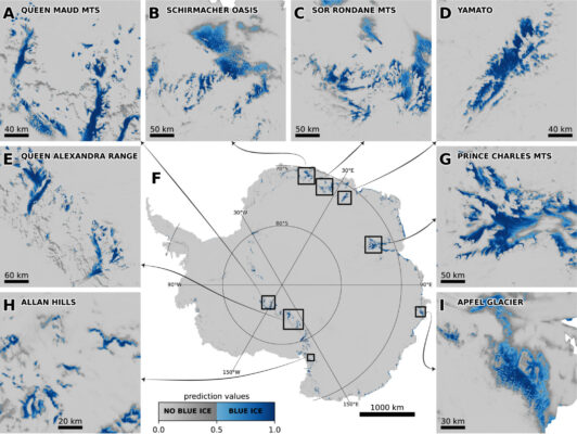
Using deep learning, we have constructed a blue ice area map of Antarctica (Figure 1). The map can help to find meteorites or old ice. The outlines can also be useful for climate models. Blue ice areas absorb more sunlight than snow (that is, they have a relatively low albedo), which enhances ice melt. However, melt and blue ice both look blue, complicating their differentiation on satellite imagery. A detailed map can help identify areas for closer examination of blue shades.
In summary, I hope our map will be useful for different applications in glaciology. However, the map is definitely not perfect, and many aspects are to be improved. For example, the resolution (now 200 m) can be refined, and the evolution of snow cover can be detected and/or modelled. Hence, many steps lie ahead … kggk, kggk, kggk.
Further reading
- COLDEX oldest ice recovery in the Allan Hills blue ice area.
- The publication I led in which we explain the methodology behind the blue ice area map.
- More about snow cover on blue ice.
- About detecting melt and how blue ice challenges this detection.
- A previous blog post on blue ice in Antarctica.
- My previous blog post on finding meteorites on blue ice.
- A good book to learn about deep learning.
Edited by David Docquier & Maria Scheel