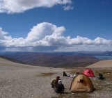
Crater Glacier, located on Mount St. Helens, Washington State, U.S., tells a tale of renewal. The catastrophic and deadly May 18th, 1980 eruption of the volcano created, among other things, a deep horseshoe-shaped, north-facing crater and obliterated most of the glaciers that resided on the volcano’s slopes. By a decade and a half later, it was clear that a glacier had formed in this unlikely location – within the volcano’s crater, adjacent to continued volcanic activity, at a mere 2,000 m in elevation. And yet, it is currently one of few expanding glaciers in the Cascade Range of the U.S. This scientifically and publicly interesting glaciation post-eruption serves as a small reminder of seemingly improbable regeneration in the wake of destruction, perhaps something we need as our world today undergoes a different kind of turmoil.
A brief geological context
Located within the Cascade Range of the northwest contiguous U.S., Mount St. Helens has a rich and complicated 275,000-year history. Volcanism at Mount St. Helens and other volcanoes in the region result from what sometimes happens when two tectonic plates meet: a process called subduction. Here, the offshore Juan de Fuca tectonic plate dives beneath the lighter North American continental tectonic plate. How does this create volcanoes like Mount St. Helens? While it is a complex process, water plays a key role. Because of high pressures and temperatures, the sinking Juan de Fuca slab releases water, which causes water-driven melting of the mantle and the production of magma deep below the surface. The apparent expression of this is a zone of volcanism – hence, the location of the Cascade Range, including Mount St. Helens.
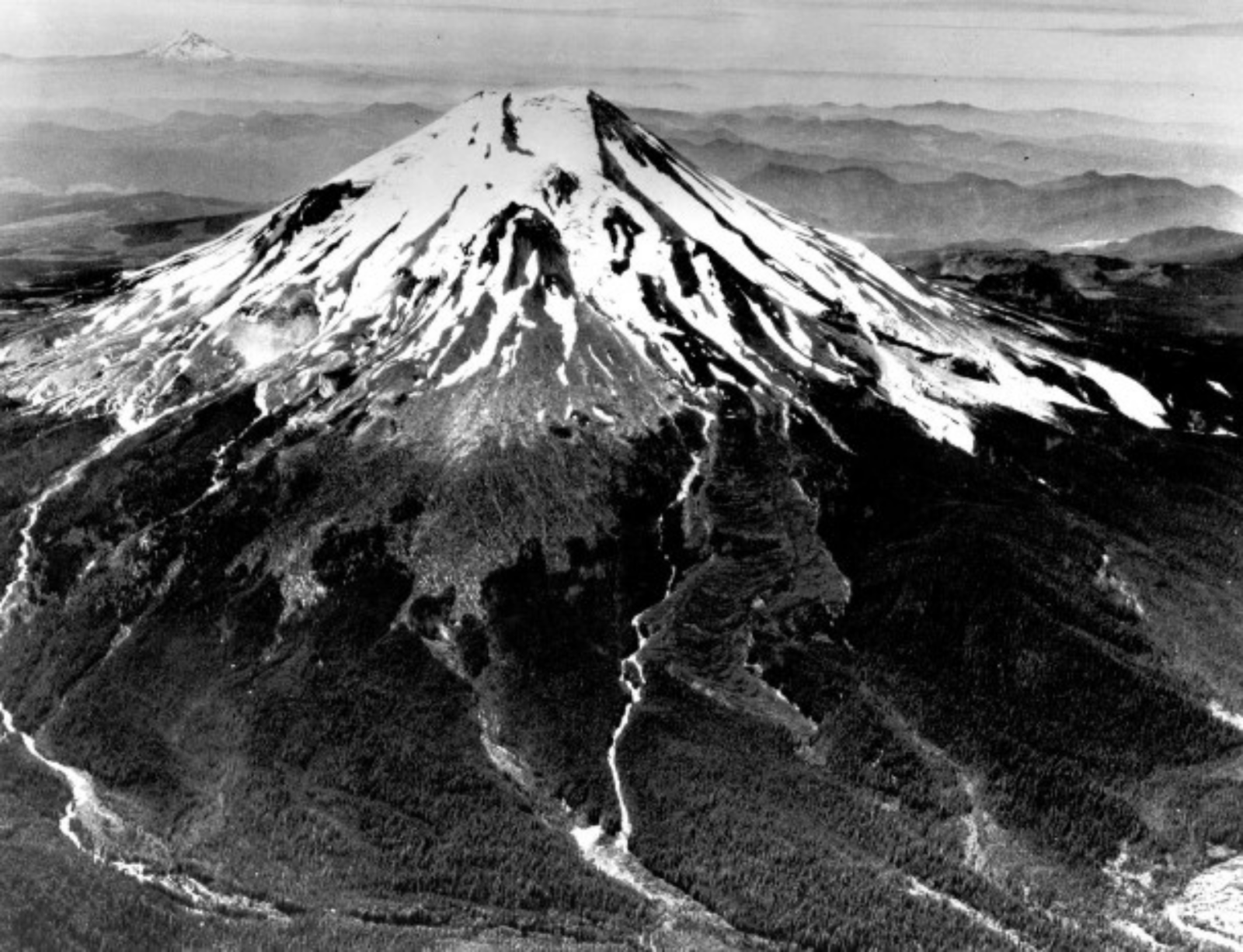
Mount St. Helens prior to the 1980 eruption. [Credit: U.S. Geological Survey]
What happened in 1980?
Imagine a glaciated, iconic cone-shaped volcano standing 2,950-m tall, sometimes referred to as “the Mount Fuji of America.” This was Mount St. Helens before 1980. But, by late winter and early spring of that year, magma began intruding into the volcano edifice and created what’s known as a cryptodome (i.e., a bulge) on the north flank of the mountain. Relatively small earthquakes and eruptions trembled through and emerged from the volcano during March, April, and early May. The cryptodome grew and became unstable until, on May 18, 1980, a magnitude-5+ earthquake and associated debris avalanche unleashed the cryptodome and unloaded the pressure confining the north side of the volcano. What followed was a catastrophic, fatal, and rapid series of events…
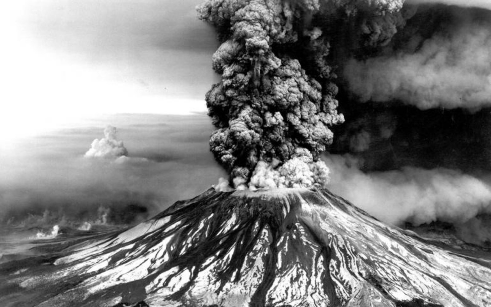
An awe-inspiring view of the eruption column of Mount St. Helens on May 18, 1980. [Credit: Robert Krimmel via U.S. Geological Survey]
- A debris avalanche: The volcano’s north side, including the cryptodome, slid away in what was known as the largest debris avalanche in Earth’s recorded history at the time (equivalent to the volume of about 1 million Olympic swimming pools).
- A lateral blast: Depressurization of the volcano triggered a highly destructive horizontally-directed explosion known as a lateral eruption or lateral blast, which removed 300 m of the volcano’s cone. The lateral blast overtook the debris avalanche, in a cloud of hot material that attained 480 km per hour. The blast devastated an area of 600 square km in 5-9 minutes, essentially killing everything in its path, flattening the trees of a forest, and covering the region with its hot debris.
- A Plinian eruption: The depressurization also sent a massive eruption cloud billowing into the atmosphere and pyroclastic flows careening away from the volcano.
- Lahars: The turbulent hot rocks and gases of the blast melted, eroded and mixed with snow and ice to create a surge of water and debris to form lahars that pummeled down the surrounding river valleys, leaving a path of destruction.
On that day, Mount St. Helens was drastically altered. What remained was a volcano with a deep horseshoe-like crater facing northward and a scarred landscape in the lateral blast’s path. The volcano continued erupting over six years in the 1980s, but nothing like the eruption on May 18. More details of the eruption day are discussed in this EGU blog post.
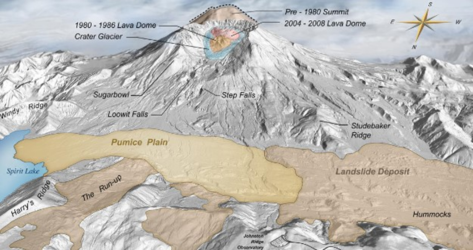
A digital elevation map showing the anatomy of Mount St. Helens and the surrounding region. [U.S. Geological Survey]
The story of Crater Glacier
But this is a blog dedicated to ice and glaciers, not to hot volcanic products. Indeed, this story also has an icy side. Before the catastrophic eruption, many perennial snowfields existed on Mount St. Helens, and eleven named and two unnamed glaciers had flowed down its flanks. During the 1980 eruption, though, 70% of the glaciers and snowfields were obliterated. What followed is a story that is relatively unique in our world today, the formation of a glacier. Doubly unique? The formation of a glacier in a volcano.
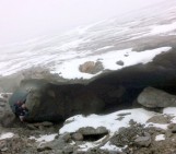
The crater of Mount St. Helens, where lava used to flow and gases used to explode out of, currently holds the youngest glacier on earth: Crater Glacier. At first glance, the volcano’s crater is an unlikely location for a glacier. Because of the high geothermal heat from the volcano and the low altitude (at 2000 m), Crater Glacier would not exist on just any other Cascade mountain. But it turns out that several characteristics of the crater make up for this: a combination of high annual snowfall, snow avalanching from the steep crater walls, shade due to the north-facing crater, and a thick layer of insulating dust and rock debris covering the glacier’s surface (look at this post to know more about the effects of debris coverage on glaciers). Due to these ideal conditions, a permanent snowfield formed there by 1988 and a glacier by 1996.
Between the 1980s and 2001, Crater Glacier increased in thickness to 200 m and expanded in volume to about 1 cubic km. Interestingly, the glacier is not all ice and snow – the large amount of rock debris from rock avalanches, detached from the steep walls of the crater, are thought to make up one third of the glacier’s volume.
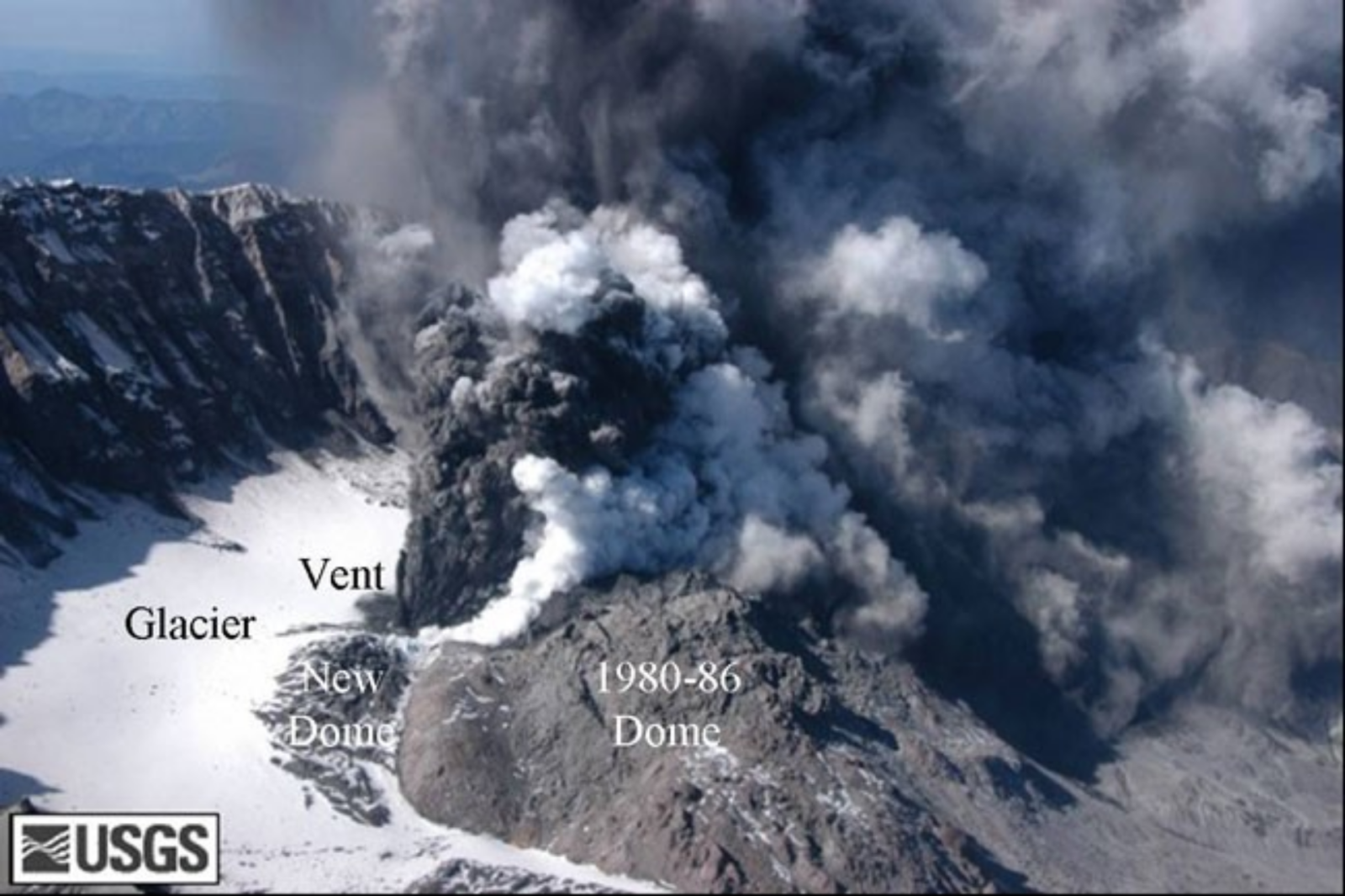
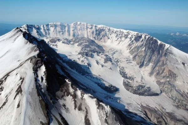
View of the crater of Mount St. Helen in 2004, showing the glacier adjacent to renewed volcanic activity. [Credit: U.S. Geological Survey and NASA]
Crater Glacier is currently one of few expanding glaciers in the region. While the glacier continues to gain volume and to advance northward since the eruption, it does so at a decreasing rate from previous years.
Whether Mount St. Helens will erupt again is a pressing question on scientists’ minds and the volcano is being monitored closely. What will happen to Crater Glacier in the future is largely dependent on the volcano. In the meantime, the unique story of the glacier serves as a scientific curiosity and an inspirational reminder of continued regeneration in the aftermath of catastrophic destruction.
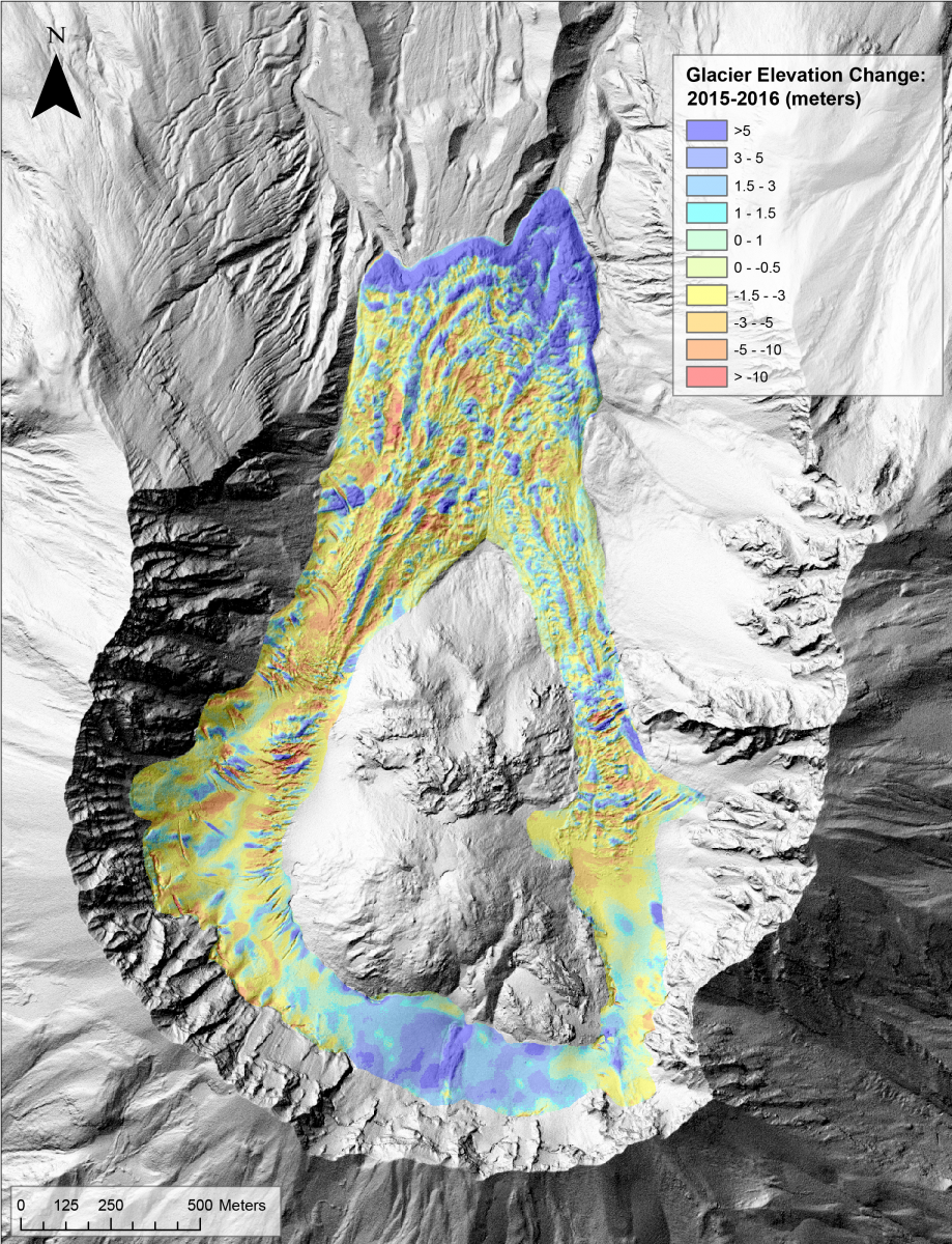
Elevation changes of Crater Glacier from 2015-2016 derived from high-resolution digital elevation models. Thickening of the glacier occurs in the south and at the terminus while thinning and crevassing occur in the glacier’s arms. [Credit: Angie Diefenbach]
Further Reading
- For more information on Mount St. Helens, please see the U.S Geological Survey web pages.
- For more on the geomorphology of Mount St. Helens: Gabrielli and others (2020). Geomorphology and surface geology of Mount St. Helens volcano. Journal of Maps 16(2):585-594.
- For more on glacier development after the 1980 eruption of Mount St. Helens: Schilling et al. (2004), Posteruption glacier development within the crater of Mount St. Helens, Washington, USA. Quaternary Research 61(3):325-329.
- For more on the role of water in magmatism at subduction zones: Grove et al. (2012). The role of H2O in subduction zone magmatism. Annual Review of Earth and Planetary Sciences 40:413-439.
Edited by Giovanni Baccolo
 Annika Horlings is a PhD candidate at the Department of Earth and Space Sciences, University of Washington (UW), U.S. Her primary research interests are in using modeling and ice-penetrating radar to study changes in near-surface processes of glaciers and ice sheets and their implications on ice-sheet mass balance. At the UW, she also avidly pursues cryospheric science outreach and works to further diversity, equity, and inclusivity initiatives. She is native to the Pacific Northwest of the U.S., where Mount St. Helens is a familiar marker on the horizon. Contact email: annikah2@uw.edu
Dan McLaughlin
Annika,
Educational and inspiring. Well written!
Thank you for sharing of your technical insights.
-Dan McLaughlin