The Greenland Ice Sheet contains enough water to raise sea level by 7.36 meters (Bamber, et. al. 2013) and much of this moves from the interior of the continent into the oceans via Jakobshavn Isbræ – Greenland’s fastest flowing outlet glacier. An ancient river basin hidden beneath the Greenland Ice Sheet, discovered by researchers at the University of Bristol, may help explain the location, size and velocity of the modern Jakobshavn Isbræ. This Research also provides an insight into what past river drainage may have looked like in Greenland, and what it could look like in the future as the ice sheet retreats exposing more of the land underneath it.
Why?
The topography (i.e. shape) of the bedrock underneath the Greenland Ice Sheet exerts a strong control on glacier ice flow , particularly the direction and velocity of ice flow. It also influences the distribution of water and sediment beneath the ice (see here for one reason why this is important). As well as this, studying the shape of the bed can provide a window into the past, to help understand historical erosive processes, which allow scientists to understand the long-term evolution of the landscape, sometimes they can even look back at what the land may have looked like before it was covered in ice. Building up this kind of picture allows researchers to assess the interaction between the Greenland Ice Sheet and its bed and how this has evolved over great time-scales, which will further understanding of how the ice dynamics have changed over time and what this might mean for the future.
How?
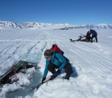
As ice is mostly transparent to radio waves at certain frequencies, scientists can use ‘ice-penetrating radar,’ either from aircraft or on the ground, to measure ice thickness as the radio waves bounce back off the bedrock. Data of this kind have been collected over several decades by research teams across the world, with more recent missions being headed by NASA (through Operation Ice Bridge). Using these data, bedrock elevation maps have been produced for both Antarctica, and Greenland allowing researchers to interpret individual features and landscapes hidden beneath the ice.
What have they found beneath the ice?
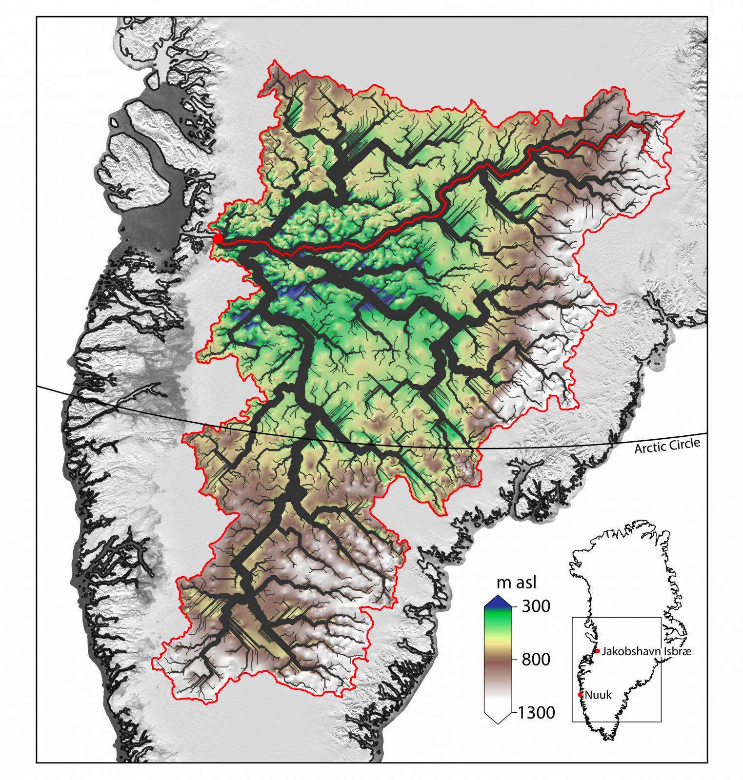
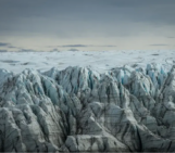
Recent research has found large channels, or ‘canyons,’ present underneath both the ice sheets of Greenland and Antarctica (e.g. Bamber, et al. 2013; Jamieson, et al. 2016), and our image of this week adds to this picture of dramatic topography underneath the Greenland Ice Sheet (Figure 1). A huge ancient basin has been discovered in southern Greenland, showing signs of being carved by ancient rivers, prior to the extensive glaciation of Greenland (i.e. before the Greenland Ice Sheet existed), rather than being carved by the movement of ice itself. The size of the drainage basin the team discovered is very large, at around 450,000 km2, and accounts for about 20% of the total land area of Greenland (including islands). This is comparable to the size of the Ohio River drainage basin, which is the largest tributary of the Mississippi – or roughly twice the size of Great Britain. The channels the team mapped could more appropriately be called ‘canyons’, with relative depths of around 1,400 metres in places, and nearly 12 km wide, all hidden underneath the ice (Figure 2).
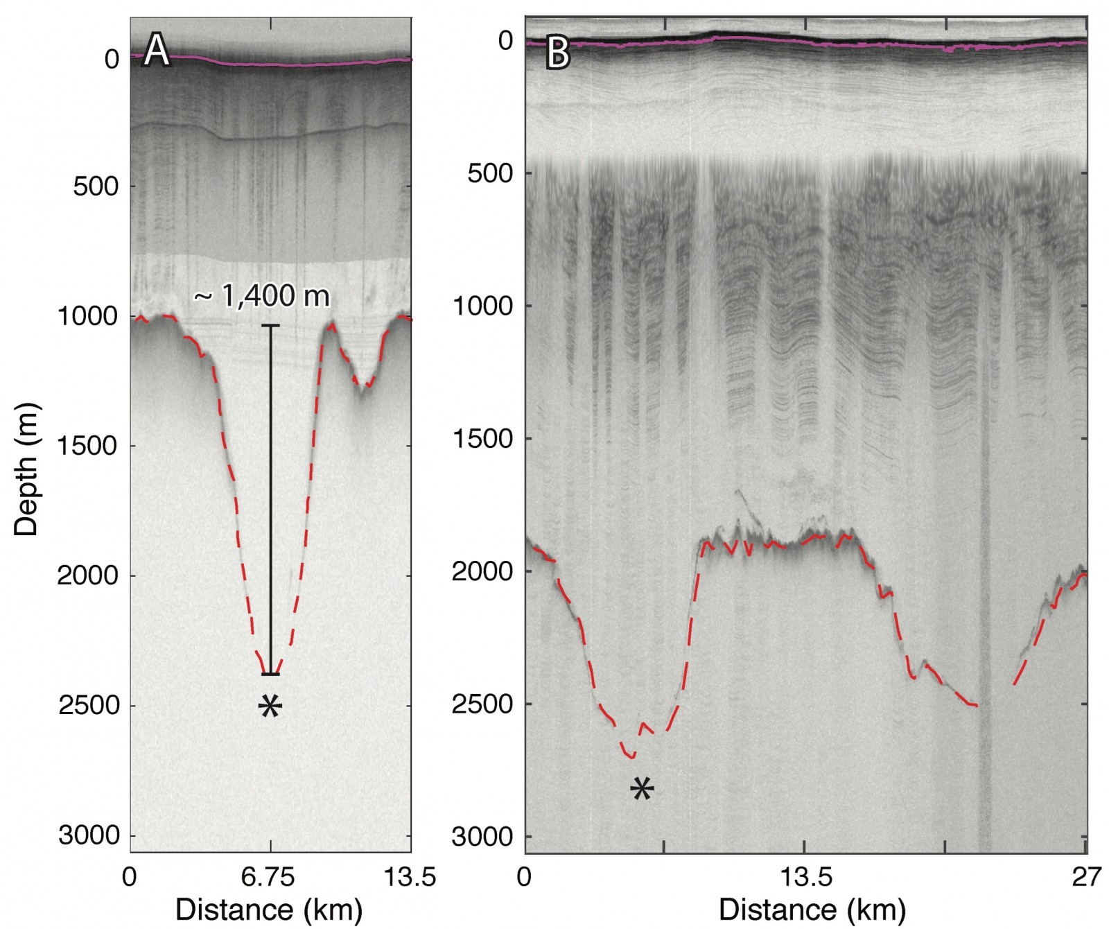
Figure 2: Ice-penetrating radargram cross-sections of some channels within the flow network, showing the size of the features hidden beneath the ice. The bed and surface have been identified: The dashed red line, shows bedrock depth relative to the ice surface, (the solid purple line). There is an exaggeration in the vertical by a factor of 13.
Take Home Message
As well as the basin being an interesting discovery of great size, the channel network and basin appears to be instrumental in influencing the flow of ice from the deep interior to the margin, both now and over several glacial cycles, and in particular controlling the location and speed of the Jakobshavn ice stream, which drains a huge amount of the Greenland Ice Sheet into the oceans. This discovery helps us to better understand why this area of Greenland contains such fast flowing ice and how this might evolve in the future.
For more details of this study check out the full paper:
Cooper, M. A., K. Michaelides, M. J. Siegert, and J. L. Bamber (2016), Paleofluvial landscape inheritance for Jakobshavn Isbræ catchment, Greenland, Geophys. Res. Lett., 43, doi:10.1002/2016GL069458.
(Edited by Emma Smith)
 Michael Cooper is a PhD Student at the University of Bristol, UK. He Investigates what lies beneath the Greenland ice sheet using airborne ice-penetrating radar, to help further understanding of the inter-relationship between ice and the bed with reference to both contemporary and past ice dynamics. He tweets from @macooperr
Pingback: Cryospheric Sciences | Exploring the hidden plumbing of glaciers with Cryoegg
Pingback: Building electronics that can survive under Greenland’s ice sheet – Best Soundcloud Rappers 2019
Pingback: Building electronics that can survive under Greenland’s ice sheet – Doblal
Pingback: Building electronics that can survive under Greenland’s ice sheet - RokzFast
Pingback: Constructing Electronics That May Survive Underneath Greenland’s Ice Sheet - ITechBlog
Pingback: Building electronics that can survive under Greenland’s ice sheet – Highlyproducts
Pingback: Construire des appareils électroniques qui peuvent survivre sous la calotte glaciaire du Groenland
Pingback: Construire des appareils électroniques qui peuvent survivre sous la calotte glaciaire du Groenland | WeBPivo
Pingback: Building electronics that can survive under Greenland’s ice sheet – Quickshopings
Pingback: Building electronics that can survive under Greenland’s ice sheet – Madmad
Pingback: Building electronics that can survive under Greenland’s ice sheet – Slikthings
Pingback: Building electronics that can survive under Greenland’s ice sheet - ACQRO
Pingback: Setting up electronics that can survive underneath Greenland’s ice sheet | Daily News Articles
Pingback: Building electronics that can survive under Greenland’s ice sheet - News Flights
Pingback: Building electronics that can survive under Greenland’s ice sheet – Ars Technica – WeGobble.online
Pingback: Building electronics that can survive under Greenland’s ice sheet - Ars Technica - News, Tips and More
Pingback: Building electronics that can survive under Greenland’s ice sheet – Everyday News Update
Pingback: Building electronics that can survive under Greenland’s ice sheet – Encryptmate
Pingback: Building electronics that can survive under Greenland’s ice sheet – Ars Technica – US News Site
Pingback: بناء إلكترونيات يمكنها البقاء تحت الغطاء الجليدي في جرينلاند
Pingback: Building electronics that can survive under the Greenland ice sheet – Al-Gulf
Pingback: بناء إلكترونيات يمكنها البقاء تحت الغطاء الجليدي في جرينلاند – GotoNews
Pingback: Building electronics that can survive under the Greenland ice sheet - Archyde