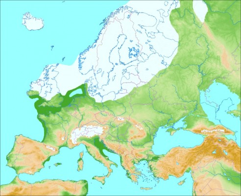
During the last ice age*, ~70,000 to 20,000 years ago, the climate was much colder in Europe.
As a result, the northern part of Europe was fully covered by the Fennoscandian (a.k.a the Scandinavian ) ice sheet, which extended up to the British Isles and some parts of Poland and Germany. In central Europe, the Alps were also almost fully glaciated.
The storage of all this ice on the continent lowered the sea level (seedark green), which substantially reduced the extent of the North Sea.
*This period is referred to as the Weichselian glaciation and the Würm glaciation in Northern Europe and the Alps, respectively.
More information
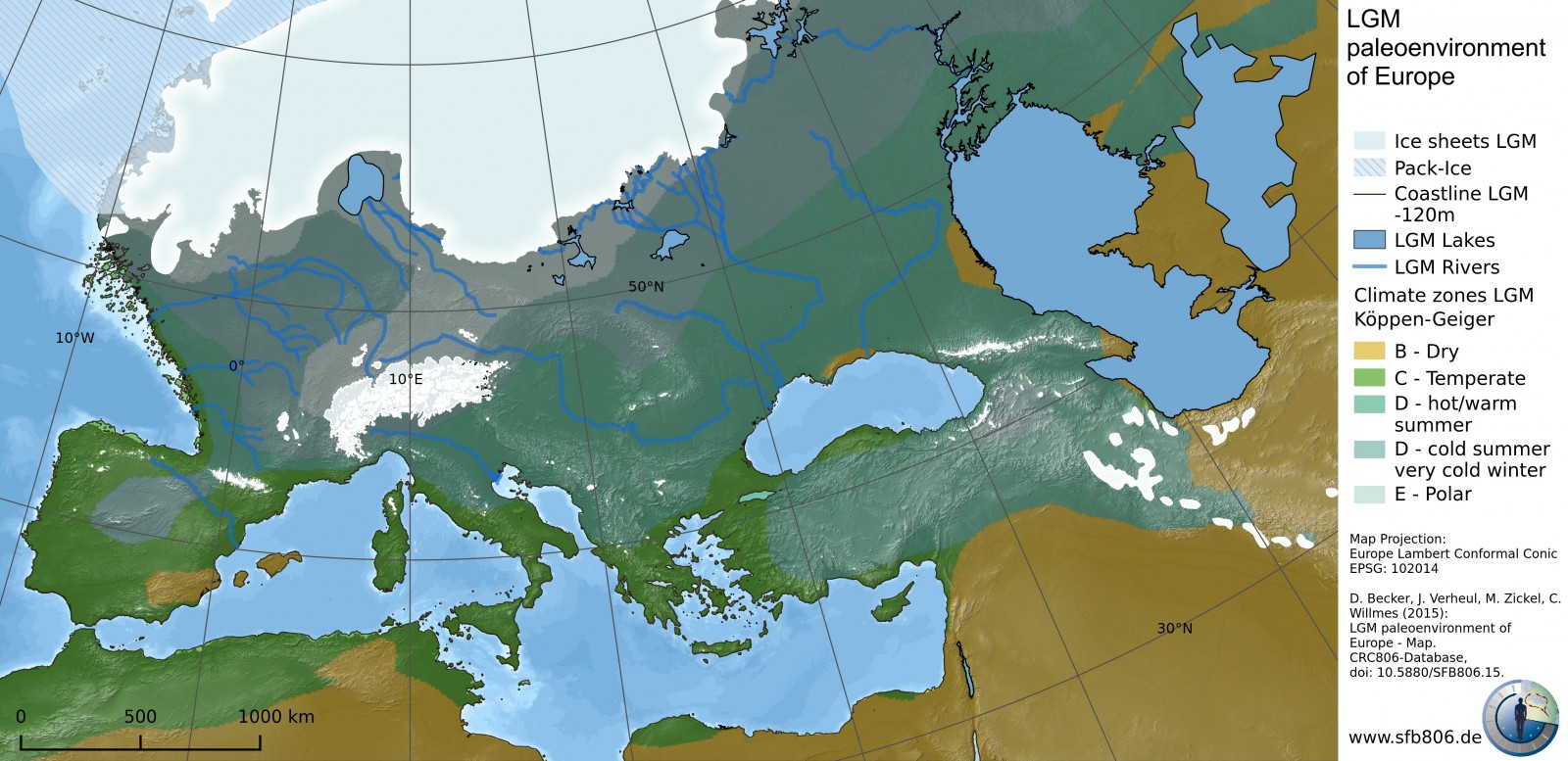
A more complete and accurate dataset (including GIS maps) of Europe during the last glacial maximum is freely available :
Becker, D., Verheul, J., Zickel, M., Willmes, C. (2015): LGM paleoenvironment of Europe – Map. CRC806-Database, DOI: http://dx.doi.org/10.5880/SFB806.15

Christian Willmes
This might be of interest here. We published a LGM Europe GIS Dataset for free reuse (CC-BY): Becker, D., Verheul, J., Zickel, M., Willmes, C. (2015): LGM paleoenvironment of Europe – Map. CRC806-Database, DOI: http://dx.doi.org/10.5880/SFB806.15
Happy to get Feedback, on what could be improoved.
Pingback: L’humanité a-t-elle vraiment réalisé l’urgence et la gravité du défi climatique ? – Science Pop
Pingback: Cryospheric Sciences | Sea Level “For Dummies”
Pingback: Cryospheric Sciences | Image of the Week — Looking back at 2016
Pingback: Eventi climatici catastrofici: l’ultima grande deglaciazione. Quale lezione per il futuro - blueplanetheart.it
Pingback: Cryospheric Sciences | Radiocarbon rocks! – How rocks can tell us about the history of an ice sheet…
Robby Larkan
I am a firm believer in the fact that the Mediterranean was dry during the last Ice age possibly as recently as 30,000 yo. This is backed up by the cart tracks found on Malta Sicily Spain and Italy and to some extent on the straights of Gibraltar being closed until the raising of the Atlantic forced the breakthrough which is also scientifically been proven. If the Ice cap extended completely into the Black sea up into the north pole it would have been a lot more Ice (water) to melt when the thaw came. This also confirms the great flood which is in many of the old folk laws and scriptures.
Yet i see very few mentions of this in the Weichselian glaciation and the Würm glaciation possibly due to the concentration on the Ice and Glacial side of Europe but this does make for a very interesting subject for someone with the overall knowledge of the subject.
Does anyone have similar views on the matter which i could follow?
Fondest regards Robby Larkan
Alfred J Howard
The depth of the Mediterranean is over 5000 metres in places, it’s not possible that it was dry, however its only 90m – 200 m between Malta and Sicily- it’s possible that these were connected (or nearly connected). Estimates are that sea levels were around 120 metres lower during the last glacial period. The straight of Gibraltar is 300m – 900m deep. It’s extremely unlikely that this was dry.
Fred
I too agree. It seems that the black sea was much smaller then is shown as is the Caspian. As for the flood myths. It seems the age had a lot of them as the lakes on the ice broke out and flooded things. Look at the sate of Washington and Oregon along with the Hudson River valley In NYS.
Further more the ppls of the ice age would of lived right up to the ice sheet having settlements as close as 100K. We do not find this in Belarus or Ruzzia. We do find settlements in UKN that come to a halt way before ur ice sheets thus making ur ice fall short. Im a firm thinker that humans were a lot more advanced then u would put them too have so form of picture writing during the ice age. Not many words in it. Mostly nouns and mostly used to say features on a may drawn in the dirt. This is why we have not record or writing until we stared doing it in stone. Dirt maps dont last and even if painted on an animal skin or wood we all know what time does to these.
albert
Having the Baltic frozen where did all the rivers running north that now discharge there flow?
jesper Bregenballe jeppesen
The photo you post of EU under Icea ge is misleading and wrong.. It shows fx Denmark but Denmark as it looks today? if so much melted ice melted and politicans/scientist keep saying water is rising?
Anne
I have seen these parallel cart tracks in Malta, on a headland high above sea level, and stopping abruptly at the edge. Seismic activity at some point in the past may have caused land to slip downwards and away, to be covered by a rising sea level, or else the land rose to its present height from an originally lower level where ships were berthed and cargo was transported by wheeled vehicles to an embarkation point. Perhaps someone has explored the sea floor beneath the cliff?
Pingback: Cryospheric Sciences | Taiwan’s Icy Past