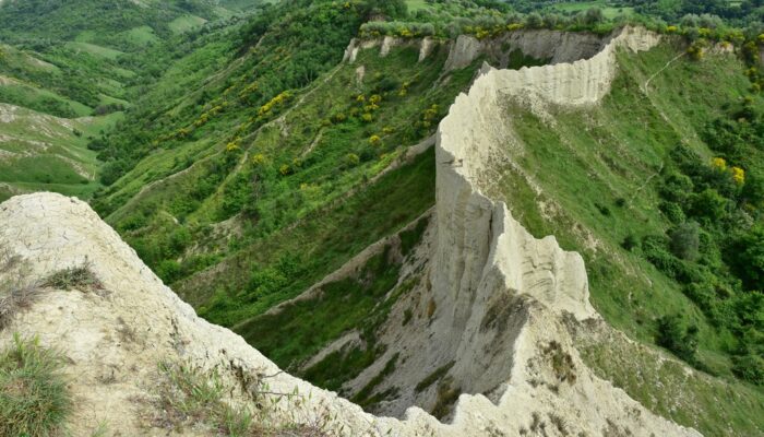
The badlands valley of Civita di Bagnoregio is a hidden natural gem in the province of Viterbo, Italy, just 100 kilometres from Rome. Pictured here is the ‘wall,’ one of the valley’s most peculiar features, where you can even find the wooden structural remains of a trail used for agricultural purposes in the 19th and 20th centuries.
The photograph was taken by Chiara Arrighi, a post-doc research assistant at the University of Florence (Italy), in May last year after climbing roughly 200 metres from the bottom of the Chiaro creek valley. Trails in this region are not well traced or maintained, so she had to find her own way up among the chestnut woods. Once at the top, the trail becomes narrow and unprotected. “The inhabitants of the area still do not exploit this natural beauty as a tourist attraction,” said Arrighi. “In fact, nobody was on the trail, and the silence [was] unreal.”
Badlands are a typical geological formation, where grains of sand, silt and clay are clumped together with sedimentary rock to form layers, which are then weathered down by wind and water. The terrain is characterised by erosive valleys with steep slopes, without vegetation, separated by thin ridges.
Due to the slope’s steep angle and the clay’s low permeability, little water is able enter the soil. Instead water quickly flows across the surface, removing surface clay and carving into the slopes as it does so.
The morphological evolution of the clay slopes can be very rapid (for example, rock falls can occur quite suddenly after heavy rainfall) and occurs as a result of several physical mechanisms, such as mud flows, solifluction (slow movement of wet soil towards the bottom of the valley) and sliding.
During the evolution of the badlands, peripheral portions of the terrain made up of volcanic deposits (tuff cliffs) rose up from the landscape, bordered by nearly vertical slopes (called scarps). Many towns have been built on these erected hilltops, such as Civita di Bagnoregio.
By Chiara Arrighi and Olivia Trani
Imaggeo is the EGU’s online open access geosciences image repository. All geoscientists (and others) can submit their photographs and videos to this repository and, since it is open access, these images can be used for free by scientists for their presentations or publications, by educators and the general public, and some images can even be used freely for commercial purposes. Photographers also retain full rights of use, as Imaggeo images are licensed and distributed by the EGU under a Creative Commons licence. Submit your photos at http://imaggeo.egu.eu/upload/.


