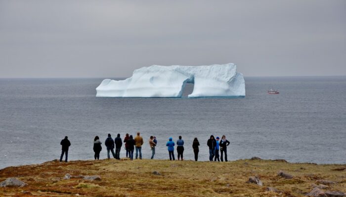
Cape Spear in Newfoundland, Canada is the easternmost location in North America and one of the few places in the world where you can contemplate icebergs from the shore. Every year, about 400 to 800 bergs journey down to this particular point. These 10,000-year-old ice giants drift along the northern shore of Newfoundland with the Labrador Current.
About 90 percent of these icebergs come from western Greenland glaciers, where they break off directly into Baffin Bay. Often these bergs remain in the bay for several years, preserved by the cold arctic waters and circulating along with local currents. Eventually, many icebergs escape through the Davis Strait, drifting down the Labrador Current and passing through Iceberg Alley to reach the Grand Banks of Newfoundland, the region of the North American continental shelf where Cape Spear is situated. This journey from Greenland to the Grand Banks usually takes between two and three years.
Cape Spear is just a few kilometres from Newfoundland’s largest city, St. John’s, and attracts many tourists during spring and early summer months to enjoy the immense icebergs. The chances of seeing them depend greatly on the temperature, wind direction, ocean currents and amount of sea ice during the winter, which protects icebergs from erosion. The icebergs have a great impact on Newfoundland’s identity and economy, bringing tourists and even giving breweries unique ice for beer and liquor production.
On the other hand, the floating ice can be a hazard to oil platforms and cargo boats. Smaller bergs can be especially hazardous since they are harder to detect with marine radar. If deep enough, the icebergs can also damage seabed structures like pipelines and cables. Thus, it is important to keep monitoring the dynamics of icebergs, especially since there will likely be a greater volume of ice breaking from the Greenland glaciers and drifting in the North Atlantic due to climate change.
By Simon Massé, PhD student, Université du Québec à Rimouski, Canada
References
Barber, D.G., Babb, D.G., Ehn, J.K., Chan,W., Matthes, L., Dalman, L. A., et al.: Increasing mobility of high Arctic Sea ice increases marine hazards off the east coast of Newfoundland, Geophysical Research Letters, 45,2370–2379, https://doi.org/10.1002/2017GL076587, 2018.
Diemand, D., Icebergs, Encyclopedia of Ocean Sciences, 3: 1255-1264, 2001.
Iceberg Finder, Icebergs Facts. Newfoundland & Labrador Tourism, 2012.
Imaggeo is the EGU’s online open access geosciences image repository. All geoscientists (and others) can submit their photographs and videos to this repository and, since it is open access, these images can be used for free by scientists for their presentations or publications, by educators and the general public, and some images can even be used freely for commercial purposes. Photographers also retain full rights of use, as Imaggeo images are licensed and distributed by the EGU under a Creative Commons licence. Submit your photos at http://imaggeo.egu.eu/upload/.