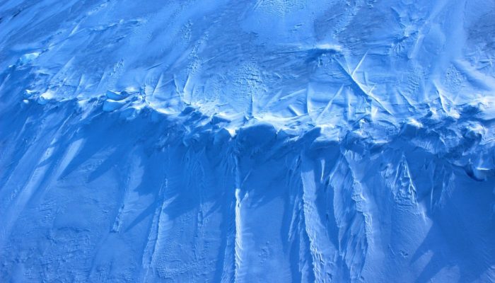
This image was taken during the Arctic Ocean 2016(AO16) expedition that ventured to the central regions of the Arctic Ocean, including the North Pole. It shows a pressure ridge, or ice ridge, as viewed from onboard the deck of the icebreaker Oden. It was quite striking that the ice ridge resembled an image of a spine – sea ice being a defining characteristic of the broader Arctic environment and backbone to global climate interactions.
An ice ridge is a wall of broken ice that forms when floating ice is deformed by a build up of pressure between adjacent ice floes. Sea ice can drift quite quickly, and is driven by wind and ocean currents. Ridges are typically thicker than the surrounding level sea ice, being built up by ice blocks of different sizes. The submerged portion of the ridge is referred to as the “keel”, and the part above the water surface is called the “sail”. Ridges can be categorized as “first year” or “multi-year” features, with weathering affecting the morphology.
In the Arctic, such ridges have been measured to in excess of 20 m in thickness including keel and sail. As someone who studies plate tectonics, these collisional boundaries between plates of ice reminded me of a downscaled mountain-building setting.
The AO16 expedition ran from August to September 2016 and involved the Swedish icebreaker Oden and the Canadian icebreaker the Louis S. St-Laurent. A wealth of geological, oceanographic, meteorological data was collected. This period appeared to have coincided with the second lowest extent of sea ice coverage on record (tied with 2007), with around 4.14 million square kilometers.
The geological evolution of the Arctic Ocean in the regions closest to the margins of northern Greenland and the Canadian Arctic Islands are some of the most poorly understood. This is largely a function of the oceanic gyre system, which causes the thickest sea ice to build up in these areas making physical access difficult. From a maritime engineering perspective, the ice ridges pose a challenge and risk to icebreaking operations and navigation. Ice ridges may determine the design load for marine and coastal structures such as platforms, ships, pipelines and bridges, and are important for both ice volume estimations and for the strength of pack ice.
By Grace Shephard, geophysicist from the Centre for Earth Evolution and Dynamics (CEED) at the University of Oslo, Norway.