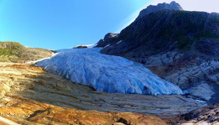
This picture shows the outlet glacier Engabreen running down from the plateau of Svartisen in Norway. Svartisen ice cap comprises two glacier systems of which the Vestre (western) Svartisen is Norway’s second largest glacier. Located right at the polar circle, Svartisen covers a total of 369 km² of the Nordland region. These coastal mountains accumulate a snowpack of 5-7 m depth through the winter season, which feeds the glaciers.
Actually, Svartisen means black ice. However, the ice of the glacier tongue of Engabreen, an outlet glacier of Svartisen ice cap, looks pretty blue in the flat light of a late afternoon in August. The ice, which is mostly free of air bubbles, transmits the blue colour more than the rest of the visible spectrum of light. Thus, by having to travel a distance of approx. 3 m through the ice body, the blue light is particularly visible.
More than the colour, it is the hydrology and the ice flow of Engabreen which are studied with attention by the Norwegian Water Resources and Energy Directorate (NVE). A tunnel system was built partly underneath the glacier in the 1990’s to collect the waters from Svartisen for hydro power production., The Svartisen Subglacial Laboratory is located at one end of the tunnel, providing a unique opportunity for direct access to the bed of a temperate glacier. The privileged location means that sub-glacial parameters can be obtained from experiments right at the bottom of a 200 m thick ice pack.
The waters of Holandsfjord have to be crossed to visit the beautiful area of the glacier lake Svartisvatnet and Engabreen. This can be either done by boat shuttle or, as we did, by kayak [ find a magazine article about Kay’s adventure here – in German -].
By Kay Helfricht, researcher at the Institute for Interdisciplinary Mountain Research of the Austrian Academy of Sciences, Austria
Editor’s note: this text was revised on Tuesday 25th October 2016 following comments from Terje Solbakk.
Imaggeo is the EGU’s online open access geosciences image repository. All geoscientists (and others) can submit their photographs and videos to this repository and, since it is open access, these images can be used for free by scientists for their presentations or publications, by educators and the general public, and some images can even be used freely for commercial purposes. Photographers also retain full rights of use, as Imaggeo images are licensed and distributed by the EGU under a Creative Commons licence. Submit your photos at http://imaggeo.egu.eu/upload/.


Pingback: GeoLog | The best of Imaggeo in 2016: in pictures
Terje S
Nice picture and post! However, the name Svartisen is old and has nothing to do with the polluting Iron plant of Mo I Rana, infamous for its red smoke that put a red stain to everything in the close vicinity until the 70s when it was cleaned, but I never heard of this red smoke reaching the glaciers. The iron plant did not start up until 1955. The name can more likely be attributed to that glacier ice has the dark blue colour in comparison to smaller glaciers (fonn) that are more white in colour, so nothing today with rock dirt either
Kay
Dear Terje, thank you for your respond and your instructive comment concerning the origin of the name Svartisen. My apologies for this false information and I’ll arrange this to be revised.