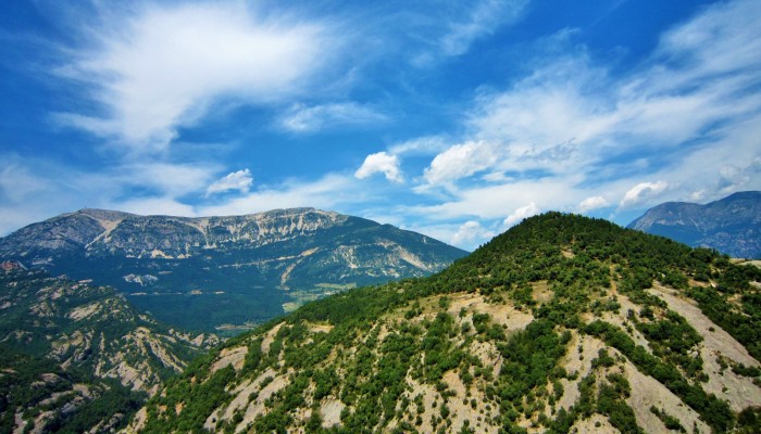
From the easterly Atlantic waters of the Bay of Biscay to the Catalan wild coast (Costa Brava) in the west, the Spanish Pyrenees stretch 430 km across the north of the country. At the foothills of the Catalan Pyrenees you’ll find the Pre-Pyrenees. Despite not reaching the soaring heights of the peaks of the Pyrenees, they nonetheless offer important insights into the geology of the range and stunning panoramas, such as the one featured as today’s Imaggeo on Mondays image. In today’s post, Sarah Weick, a researcher at the Georg August University in Göttingen, explains why the foothills of the mountain belt are a structural geologist’s playground.
The picture was taken from the top of the flat-topped mountain ‘Mola de Lord’, with a beautiful view over the turquoise-blue water of the river Cardener and growth folds, characterised by a significant increase in throw with depth, caused by their syn-sedimentary development The over 1000 m-high mountain belongs to Vall de Lord, close to the Sant Llorenc Growth Structure, formed of folded sedimentary rocks of marine and continental origin that developed from Eocene to Oligocene and display local angular unconformities (where horizontally parallel sedimentary rocks are deposited atop previously tilted layers). Moreover, it is excellently preserved as a structure in the footwall of the Pyrenees and helps to understand how sedimentary deposits are reorganized during the development of a syn-sedimentary growth structure and how they may distribute between the foreland basin and the mountain belt. Outcrops on the mountain top are of conglomeratic composition with clasts and fossilized nummulites – lense-shaped single-celled sea creatures with shells that lived from Paleocene to Oligocene.
As a geologist, Mola de Lord is not the only remarkable location in Catalonia. On a greater scale, the table mountain belongs to the Spanish Pyrenees. There, hikers can experience parts of untouched nature, and witness the mountain’s geological past: from eroded carbonate karsts with unique shapes to the Ebro basin.
The Pyrenees are located in southwest Europe on the border between France and Spain. The Upper Cretaceous to Miocene collision and subduction of the Iberian microplate under the European plate initiated the orogeny, which went through two main phases. The tectonic changes during the Alpine Orogeny that started 66 Ma ago and some earlier Jurassic activity, caused a compressive regime and thus produced a lot of pressure that caused folding on different scales and the continuing orogenic growth. Deformation occurred also after the collision. The orogenic basement can be described by inherited folded formations over a granitic basement.
By Sarah Weick, researcher at the Georg August University in Göttingen.
Imaggeo is the EGU’s online open access geosciences image repository. All geoscientists (and others) can submit their photographs and videos to this repository and, since it is open access, these images can be used for free by scientists for their presentations or publications, by educators and the general public, and some images can even be used freely for commercial purposes. Photographers also retain full rights of use, as Imaggeo images are licensed and distributed by the EGU under a Creative Commons licence. Submit your photos at http://imaggeo.egu.eu/upload/.


