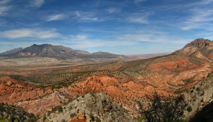
In 1877, the United States Geological Survey published a report “On the Geology of the Henry Mountains”, on the small range of peaks in southern Utah, pictured here. Up to that point, little scientific study had been made of the unassuming peaks, but the author of the report, one Grove Karl Gilbert, not only detailed the structure and mineralogy of the landscape, but in doing so also laid the foundations for much of modern geomorphology.
While beautiful, the range is isolated and of limited economic value; Gilbert himself notably wrote that “No one but a geologist will ever profitably seek out the Henry Mountains”, while the name given to the range by the Navajo Nation is Dził Bizhiʼ Ádiní, literally meaning “mountain whose name is missing”. And yet, the wildness of the range is sufficient attraction for some!
by Robert Emberson
Robert Emberson is a Postdoctoral Fellow at NASA Goddard Space Flight Center, and a science writer when possible. He can be contacted either on Twitter (@RobertEmberson) or via his website (www.robertemberson.com)
Imaggeo is the EGU’s online open access geosciences image repository. All geoscientists (and others) can submit their photographs and videos to this repository and, since it is open access, these images can be used for free by scientists for their presentations or publications, by educators and the general public, and some images can even be used freely for commercial purposes. Photographers also retain full rights of use, as Imaggeo images are licensed and distributed by the EGU under a Creative Commons licence. Submit your photos at http://imaggeo.egu.eu/upload/.
April Abate-Adams
Boy, is this post inaccurate. These aren’t even the Henry Mountains. The Henry’s are igneous laccoliths that incidentally, are currently being mined for metals. The photo shown here is likely the rock formations found in the Grand Canyon which are sedimentary.
Olivia Trani
Hi April, thank you for your comments. Here’s the photographer/author of the blog post’s response, who is happy to provide more info to clarify: “The photo was taken on the North slopes of Mt Ellsworth (southern most of the Henry peaks) looking NW. To the right of the photo in the mid distance is Mt Holmes, and in the far distance in the centre is Mt Hillers. As you point out, laccoliths are an important aspect of the landscape here, and you can see the top of Mt Holmes (right of image) has a different lithology which is indeed an example of the laccoliths. You can also see the tilted sedimentary beds on Mt Hillers (centre) which have been uplifted by the intruding laccolith that forms the centre of this mountain. As for mining, I am aware that the whole area is a prospecting target for Uranium mining, but no mining infrastructure was evident when we visited last year – perhaps we missed the areas where mining is being undertaken. Hope this helps!”