This week’s Imaggeo on Mondays image blends a range of geoscience disciplines. The post, by Irene Marzolff, a researcher at Johann Wolfgang Goethe-Universitaet, explores how the mountains, rivers and soils of the High Atlas in Morocco are intrinsically linked to the agriculture of the region.
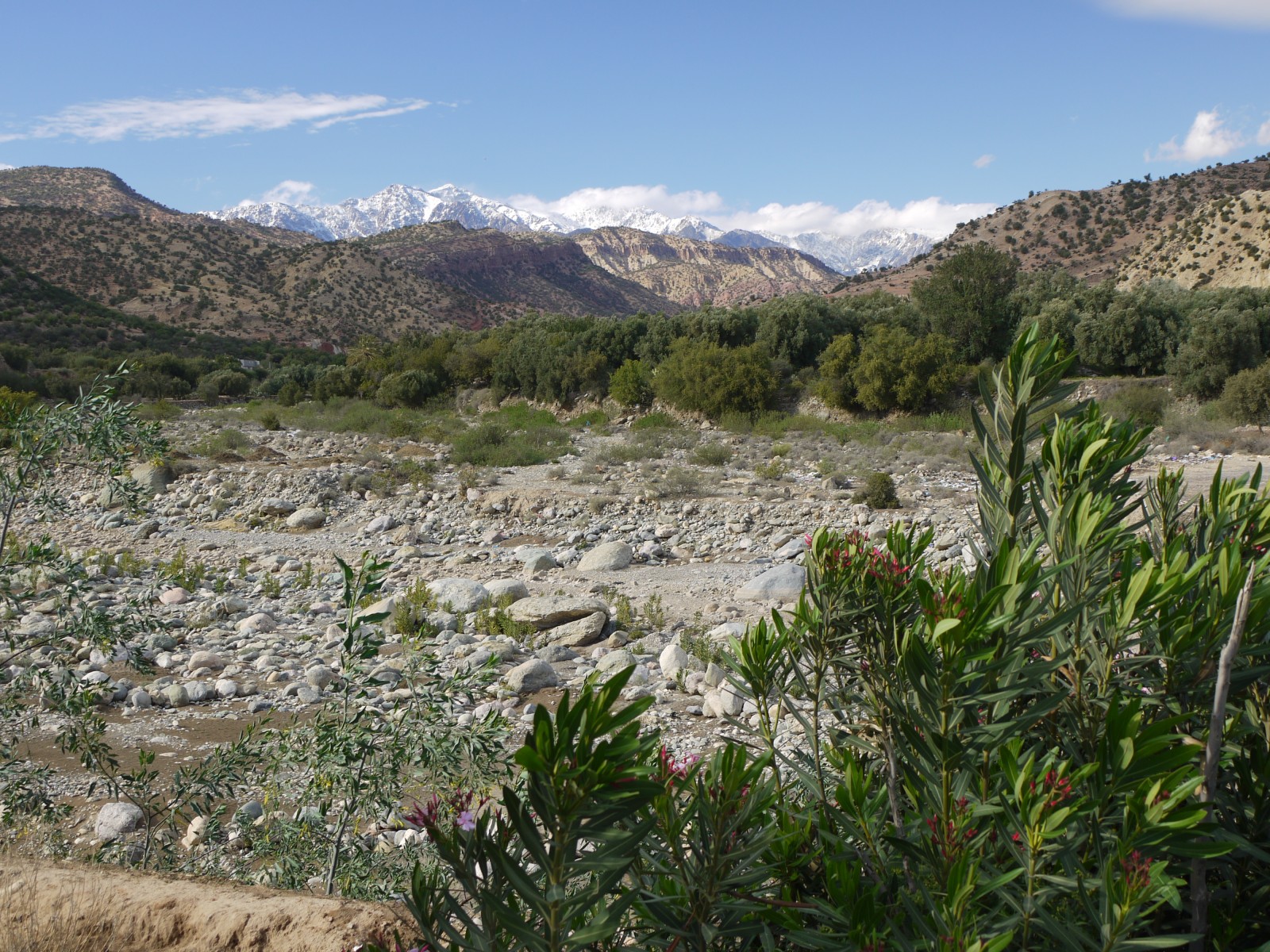
High Atlas landscape. Credit: Irene Marzolff (distributed via imaggeo.egu.eu)
The image was taken in the southern slopes of the Western High Atlas, north of the city of Taroudannt. The snow of these mountains, which in April is still prevailing on the highest ranges in the background of the photo, is a significant water resource for the region. The high interannual variability of precipitation and its changing patterns associated to climate change present a serious challenge for natural environment and for the sustainable use of water as a resource in agriculture and tourism, the two major economic sectors in the area.
A characteristic open cover of Argan trees (Argania spinosa) can be seen on the lower mountain slopes in the middle distance of the photo: an endemic species with small, oil-rich fruits resembling olives that yield high-quality oil used in medicine, food and cosmetics. The species is a relic of the Tertiary (66 to 2.8 million years ago) but has been under threat from human exploitation for centuries, by excessive grazing, fire-wood cutting, charcoal making and changes to the groundwater table. The area is part of the UNESCO-MAB Biosphere Reserve “Arganeraie” committed to the preservation and sustainable use of the trees.
The river bed in the foreground is formed by fluvial processes typical for this high-mountain region, with highly variable seasonal discharges controlled both by rainfall and snowmelt. It will in the near future drain into the Sidi Abdellah Reservoir that is currently being constructed near Tamaloukt. This reservoir will add to the 10 already existing water storage lakes in the region of Souss Massa Drâa, which is in urgent need of additional water resources: The Souss Valley to the South of the High Atlas is one of Morocco’s most intensely farmed agricultural regions, with agro-industrial production of bananas, vegetables and citrus fruit. Much of this, including 90% of Morocco’s tomato production, is exported to the European market.
By Irene Marzolff, researcher at the Institut fuer Physische Geographie, Johann Wolfgang Goethe-Universitaet, Frankfurt.
Imaggeo is the EGU’s online open access geosciences image repository. All geoscientists (and others) can submit their photographs and videos to this repository and, since it is open access, these images can be used for free by scientists for their presentations or publications, by educators and the general public, and some images can even be used freely for commercial purposes. Photographers also retain full rights of use, as Imaggeo images are licensed and distributed by the EGU under a Creative Commons licence. Submit your photos at http://imaggeo.egu.eu/upload/.