
Landslides have been in the news frequently over the past 12 months or so. It’s not surprising considering their devastating consequences and potential impact on nearby communities. Data collected by Dave Petley in his Landslide Blog shows that from January to July 2014 alone, there were 222 landslides that caused loss of life, resulting in 1466 deaths.
A recent paper, in the journal Natural Hazards and Earth System Sciences investigates, what the potential effects of human denudation can have on the occurrence of landslide events. There is no denying that landslide susceptibility has been increased by human activity. Global warming and greater precipitation are key contributing factors to the rise in the number of landslides which occur globally. On a local scale, the building of infrastructure, particularly roads and felling of trees to make way for agriculture are largely to blame for increased numbers of slides and slumps.
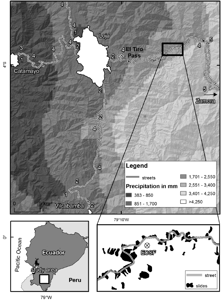
Overview of the study area with mean annual precipitation patterns (top panel), and its location in southern Ecuador (lower left panel). Highways Troncal de la Sierra E35 and Transversal Sur E50 extend in the north–south and east–west direction, respectively. The numbers along the street refer to the corresponding geological unit (1: unconsolidated rocks; 2: sedimentary rocks; 3: volcanic rocks; 4: metamorphic rocks; 5: plutonic rocks). Precipitation data are taken from the study of Rollenbeck and Bendix (2001). From Brenning et al., (2015). Click on the image for a larger version.
The research presented in the paper focuses on landslides along mountain roads in Ecuador, where drainage systems and stabilisation of hillsides is often inadequate and is known to increase the likelihood of landslides. This problem is not exclusive to Ecuador and is often linked to poorer infrastructure and engineering in developing countries. In addition, the study area is a tropical mountain ecosystem, which is naturally more sensitive and prone to landslides. The key question here being: are more landslides likely to happen close to a road (in this particular case an interurban highways), or does greater distance from them offer some hazard relief?
The geology, and local climate and vegetation are important factors to also take into consideration when carrying out an assessment of this nature. Highways E35 and E50 run along Southern Ecuador and intersect the Cordillera Real, which creates a strong local climate divide and generates a precipitation gradient along the area studied. Páramo ecosystems are dominant towards the east, whilst tropical dry forests are common in the west. The geology is also variable across the area studied: dipping and jointed metamorphic rocks are dominant, but are in contact with horizontally layered sedimentary units of loose conglomerates and sandstones. Additionally, the hill sides running along the highways are often deforested to make way for coffee, sugar cane and banana crops. When they are not, they are commonly handed over to cattle for grazing.
By mapping, in great detail, all landslide occurrences within a 300m corridor along the highways, the researchers were able to digitise 2185 landslide initiation points! In total, 843 landslides were mapped and classified by recording the type of movement experienced, as well as the material type (soil, debris or rock) and whether the slide was still active, inactive or had been reactivated. The detailed data meant it was possible to statistically model the likelihood of landslides occurring in close proximity to the highway (25m) vs. some distance away (200m). The results showed that susceptibility to landslides increases by one order of magnitude closer to the highway when compared to areas between 150-300 m away from the mountain road. Furthermore, slides close to the highway were found to be more likely to be reactivated than those a greater distance away.
The study found that the local topography, geology and climate conditions had a lesser influence on the likelihood of landslides. However, the influence of stretches of mountain road constructed in the sedimentary units seems to enhance the hazard.
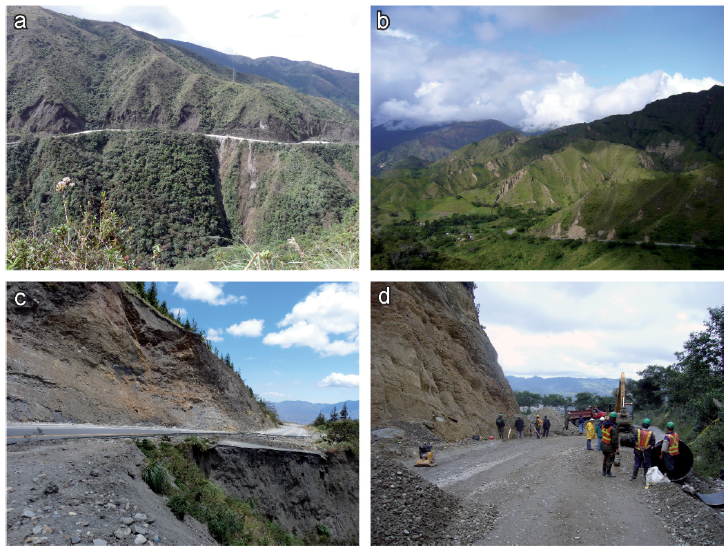
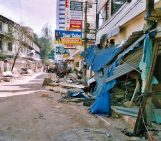
Landslides occurring along the investigated highways. (a) Typical landslides of the wet metamorphic part of the study area in the
east. (b) Typical landslides of the semi-arid, conglomeratic part of the study area in the west. (c) Highway destroyed by landsliding. (d) A
highway is cleared from a recent landslide occurrence. From Brenning et al., (2015).
In future, the model can be used to predict locations where landslides are more likely to occur along the E35 and E50. Recently, engineering works have been carried out along the studied stretch of highways to stabilise the hillsides. The data collected as part of the research presented in the paper will be useful in the future to monitor the efficacy of the improvements. On a larger scale, further studies of this type could be used by local governments when planning new infrastructure and could lead to incorporation of cost-effective mitigation measures in new developments.
By Laura Roberts Artal, EGU Communications Officer
Reference:
Brenning, A., Schwinn, M., Ruiz-Páez, A. P., and Muenchow, J.: Landslide susceptibility near highways is increased by 1 order of magnitude in the Andes of southern Ecuador, Loja province, Nat. Hazards Earth Syst. Sci., 15, 45-57, doi:10.5194/nhess-15-45-2015, 2015.
John Rehm
I agree with the premis, completely. Forest roads DO cause more landslides. You clear a road and there are now open spots in the forest canopy for rain or snow to be caught and seep into the road. Did this work in Oregon in the 90s. Same conclusion. The USFS closed some of these roads.