That landslides are hazardous goes without saying; the risk posed by them will largely depend on where they occur and their exact characteristics, which makes understanding the mechanisms which trigger them, as well as predicting when they might happen, extremely difficult. Today’s Imaggeo on Mondays image, brought to you by Ekrem Canli, a PhD student at the University of Vienna, is an example of how scientists are trying to get a better handle on landslide mechanics.
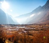
The Salcher landslide is situated in the transition zone between the Flyschzone and the Klippen Zone; both belonging to the most landslide prone areas in Austria exhibiting almost 5 landslides per km². Flysch materials in that area consist of alternations of fine grained layers (clayey shales, silty shales, marls) and sandstones, whereas the Klippen Zone is covered by a sequence of marly beds with intercalated sandy limestones.
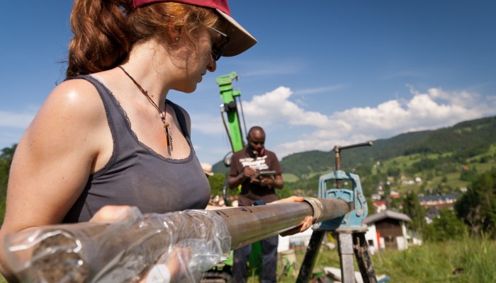
Our featured Imaggeo picture shows students during field work at the Salcher landslide observatory in Gresten (Austria) extracting sediment cores from percussion drilling – a technique in which core samplers are driven into the soil by repeated hammer blows using a percussive drilling rig.
The Salcher landslide observatory was initiated in 2014 as a long term monitoring project (10+ years). On the one hand, an increased frequency of landslide occurrences in many parts of the world is commonly listed as an expected impact of human-induced climate change. On the other hand, the lack of historic or long term monitoring information on landsliding makes is difficult to correlate landslide occurrence and its triggering event (e.g. intense rainfall, ground vibrations) with past and potentially future conditions. Additionally, most landslides are not in a constantly active state – meaning they are at rest and not moving downslope – but are only reactivated after certain triggering events before they eventually come to a halt again. This dormant state may cover several years or even longer, which most landslide monitoring efforts do not cover so far. Consequently, monitoring systems with automated instrumentation, which allows for regular, remote observations to be gathered, have been of great value in the past in terms of understanding forthcoming landslide dynamics.
The monitoring setup at the Salcher landslide observatory covers current state-of-the-art methods in landslide investigation (such as inclinometers, piezometers, TDR probes, etc., see this paper for more information on monitoring landslides) combined with rather new and innovative techniques, such as permanent terrestrial laser scanning (pTLS – for an automated high resolution surface change detection on a daily basis) or permanent ERT (Electrical resistivity tomography) for spatially monitoring the propagation of rainwater in the subsurface every three hours. Additionally, percussion drillings and dynamic probing was performed on a longitudinal section of the landslide for a better structural interpretation of the landslide subsurface.
And on a more personal side note: everything looks so shiny and bright while presenting results on conferences…most of the time, however, you spend time on fixing (and cursing) things in the field that seem not to work for any particular reason. You are not alone out there!
By Ekrem Canli, PhD student, University of Vienna (ENGAGE working group on Geomorphological Systems and Risk Research).
References
Canli, E., Thiebes, B., Engels, A., Glade, T., Schweigl, J., and Bertagnoli, M.: Multi-parameter monitoring of a slow moving landslide in Gresten (Austria), Geophysical Research Abstracts, Vol. 17, EGU2015-223-3, EGU General Assembly 2015
Canli, E., Höfle, B., Hämmerle, M., Thiebes, B., and Glade, T.: Permanent 3D laser scanning system for an active landslide in Gresten (Austria), Geophysical Research Abstracts, Vol. 17, EGU2015-2885-2, EGU General Assembly 2015
Crozier,M.J.: Deciphering the effect of climate change on landslide activity: A review, Geomorphology, Volume 124, Issues 3–4, doi:10.1016/j.geomorph.2010.04.009, 2010
Petschko, H., Brenning, A., Bell, R., Goetz, J., and Glade, T.: Assessing the quality of landslide susceptibility maps – case study Lower Austria, Nat. Hazards Earth Syst. Sci., 14, 95-118, doi:10.5194/nhess-14-95-2014, 2014.
Supper, R., Ottowitz, D., Jochum, B., Kim, J.-H., Römer, I., Pfeiler, S., Lovisolo, M., Gruber, S., and Vecchiotti, F.: Geoelectrical monitoring: an innovative method to supplement landslide surveillance and early warning, Near Surface Geophysics, Volume 12, Issue 1, doi:10.3997/1873-0604.2013060, 2014
Wieczorek, G.F., and Snyder, J.B.: Monitoring slope movements, in Young, R., and Norby, L., Geological Monitoring: Boulder, Colorado, Geological Society of America, p. 245–271, doi: 10.1130/2009.monitoring, 2009,
Imaggeo is the EGU’s online open access geosciences image repository. All geoscientists (and others) can submit their photographs and videos to this repository and, since it is open access, these images can be used for free by scientists for their presentations or publications, by educators and the general public, and some images can even be used freely for commercial purposes. Photographers also retain full rights of use, as Imaggeo images are licensed and distributed by the EGU under a Creative Commons licence. Submit your photos at http://imaggeo.egu.eu/upload/.