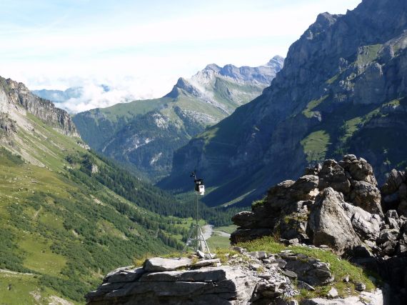
Automatic weather stations (AWS) play a prominent role in making meteorological measurements in remote areas. These measurements can feed into climate models; providing better projections for rainfall, temperature and more. This peculiarly perched piece of equipment is just such a weather station:

“Alpine Meteorology” by James Thornton, distributed by the EGU under a Creative Commons licence. Wondering where it is? Right here: 46.213546 N, 7.092183 W, sitting in the heart of the Vallon de Nant Natural Reserve, Switzerland.
Out in the Swiss Alps, this AWS is making measurements of temperature, precipitation, wind speed, relative humidity and solar radiation every 15 minutes. The photographer, James Thornton, says “the data provided by a network of these stations measuring over a period of several years can help us understand how the measured variables change over space and time”. Indeed, the more fine-scale measurements there are; the better meteorologists can make their models – for both short- and long-term changes.
The aim of this station – and the network of others like it in the Swiss Alps – is to obtain a better understanding of how the water cycle is changing in alpine environments. The data from these stations has been incorporated into a complex hydrological model known as WaSiM-ETH and applied to a number of high alpine river catchments to determine the temporal and spatial variation in snowmelt and runoff from glacier-covered regions.

Satellite image of the Swiss Alps, taken in September 2002. The northern peaks are snow covered above 2000 metres, but there is little or no snow on the peaks further south. (Credit: NASA)
Since the 1940s, the Alpine basin has had no change land use and relatively constant land cover, making it ideal for investigating how climate variability has influenced hydrological processes in the last century. Daniela Balin and colleagues have found that dominant control on the region’s hydrology is the way in which snow is stored over the course of a year. When more snowpack is preserved into the early summer, there is a greater chance of high river flow. This is because high precipitation at this time of year, together with late snowmelt, combines to produce a large amount of runoff. The effects of this are likely to be amplified in future as convective rainfall events increase. These results mean the Swiss Alps are likely to be sensitive to future climate change, particularly as snowmelt (and therefore temperature), has the biggest influence on the region’s hydrology.
This same model has been used to assess how interaction between glaciers and snow cover affect alpine river basins. Comparing the influence of snowmelt, glacier runoff and other factors that influence hydrology, Mark Verbunt and his team found that snow storage and melting processes had a stronger control on runoff in catchments that had a lot of glacier cover. If the glacier was snow-free, there would be more glacial melt than in the areas of the glacier that were snow-covered. This is because snow covered areas are more reflective (they have a higher albedo). The colour of a glacier is highly variable and because ice is darker than bright white snow it absorbs more solar radiation and melts more readily.
For more on how AWS are being used to monitor atmospheric processes, take a look at the Dust in the Desert series by James King, who is using AWS to collect dust emission data from the African continent.
References:
Balin, D. et al. Temperature-driven ‘meteorological memory’ and hydrological response of an Alpine river basin. Conference abstract (EGU2013-11700)
Verbunt, M. et al. The hydrological role of snow and glaciers in alpine river basins and their distributed modelling. Journal of Hydrology 282, 36–55, 2003
Imaggeo is the EGU’s online open access geosciences image repository. All geoscientists (and others) can submit their images to this repository and since it is open access, these photos can be used by scientists for their presentations or publications as well as by the press and public for educational purposes and otherwise. If you submit your images to Imaggeo, you retain full rights of use, since they are licensed and distributed by the EGU under a Creative Commons licence.


