The region around the Pic Saint-Loup is a popular destination for many European universities to teach mapping field courses – and there is a reason for it, even besides the great landscape, good food and nice weather. Let’s take a tour to discover why!
The Pic Saint-Loup itself is indeed so impressive that some former students return at later stages in life “dragging” along other geologists friends to give them a tour and reminisce one of their first geologic field mapping encounters. So my thanks goes out to one of those former University of Potsdam students, who showed me the area and shared his enthusiasm for the region during a short visit this summer, ultimately resulting in me writing this blog post now.
The Pic Saint-Loup is located 20 km north of Montpellier, southern France. With 658 m it is the highest mountain in the area and being visible from town as well as the Mediterranean coast it offers a popular destination for a short get-away. Geographically it is located at the southern outskirts of the Cévennes mountains, but is not considered part of them.
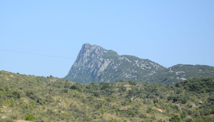
Approaching the Pic Saint-Loup from the south, as we did, you see a gently ascending green mountain rising above the hilly landscape. And to be honest, approaching it from this direction this mountain does not seem to be particularly spectacular (except for being the highest feature there), so I started to wonder: What’s the fuss about? Expressing this to my travel companion however, I was told to “wait and see”, so I did and I was not disappointed. Because while the southern mountain front is pretty gentle and “innocent”, the northern is surely not. That side is a vertical limestone cliff stretching along the entire length of the mountain. Something especially apparent when viewed from the side.
The side view becomes even more intriguing as it also offers the perspective of the Hortus mountain opposing and apparently mirroring the Pic Saint-Loup to the north. If I would not have been previously spoiled by my travel companion, looking at these two opposing cliffs, my first impression would likely have been along the lines: These are the two limbs of a large anticline whose middle been eroded completely. A feature like that would be impressive enough, but this remote interpretation would have been incorrect.
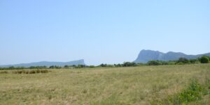
Pic Saint-Loup (right) and Hortus (left) from the side, the first notion of these two mountains once belonging together is wrong though. (Credit: Lauretta Kaerger)
The true geologic origin of the Pic Saint-Loup is only revealed on closer inspection. In our case, during a hike to the summit. Though arduous in the summer heat this tour is similarly popular with locals and tourists. Following the steeply dipping limestone layers sticking out of the path, which turned completely vertical near the summit creating maze-like structures we had to find our way through, we eventually made our way to the top. The sharp limestone made the hike technically a bit challenging and likely caused several tourists to question if sandals were indeed the right choice of footwear for this.
We did not take compass measurement on our way up – we were on holidays after all – but even without, it was obvious that the layering we encountered here differed significantly from the more or less horizontal layers we had previously observed in the surroundings.
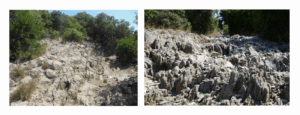
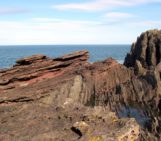
Path leading up onto the Pic Saint-Loup, the vertical layering is clearly visible – as well as the (sandal-destroying) sharpness of the limestone (Credit: Lauretta Kaerger)
The top of the Pic Saint-Loup reveals beautiful views of the coastline, Montpellier and if you lucky (which we were not) rumours has it you can even see the Alps. However, the actual fascination of this mountain is revealed when looking down – just down: 300 m straight to the ground, along the vertical layers of the northern mountain front. Absolutely dizzying, if you are not completely free from giddiness.
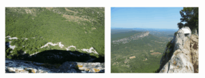
The view from the top down the vertical northern mountain front and to the Hortus mountain is staggering. (Credit: Lauretta Kaerger)
After recovering from the view down (and the climb to the summit), the view to the south should also be given some attention as it might provide an indication for the origin of the mountain. There, on clear days, the Pyrenees mountains can be seen, which are closely connected to the formation of the Pic Saint-Loup.
Being made up of Upper Jurassic limestone, so about 150 Mio years old, the Pic Saint-Loup was uplifted as part of the Pyrenees orogeny during the Eocene, about 50 Mio years ago, which was caused by the collision between Iberian microplate and the European plate. The pressure from the south folded the originally horizontal Jurassic limestone layers of the Pic Saint-Loup into an anticline whose northern limb turned vertical (in parts even overturned layers can be found). Most of this anticline is now eroded and what we see today as Pic Saint-Loup is mostly this northern limb. Additionally, the Jurassic layers were thrusted over the younger Cretaceous layers north of it along a E-W striking fault bounding the northern edge of the mountain and possibly also being responsible for its staggering northwards side. Unfortunately, the fault is covered by a large colluvial fan at the foot of the mountain, so we could not investigate it.
1,5 km north of the fault the Hortus mountain seems to mirror the Pic Saint-Loup: one gently sloping side and a sharp mountain cliff facing the Pic Saint-Loup, seemingly forming its counterpart. However, despite the visual similarly the formation of the Hortus mountain differs. It is younger made of Cretaceous limestone (100-140 Mio years ago) with subhorizontal layering, indicating that it remained, despite its close proximity, largely unaffected by the tectonic processes which formed the Pic Saint-Loup. This contrasting deformation histories adds an additional interesting layer to the regions geology – especially to mapping students.
Now you know your next geologic travel destination, maybe in combination with Pyrenees? Who knows you could impress and make curious your non geologist travel companions.
References:
Bureau de Recherches Géologiques et Minières Service Géologique National, Carte géologique de la France a 1/50000 St-Martin-de-Londres XXVII-42 963N, Ministère de l’Industrie, Orléans Cédex, France. Retrieved 16th September 2025, from: http://ficheinfoterre.brgm.fr/Notices/0963N.pdf
Parizot, O., Missenard, Y., Barbarand, J., Blaise, T., Benedicto, A., Haurine, F., & Sarda, P. (2022). How sensitive are intraplate inherited structures? Insight from the Cévennes Fault System (Languedoc, SE France). Geological Magazine, 159(11-12), 2082-2094.
Séranne, M., Couëffé, R., Husson, E., Baral, C., & Villard, J. (2021). The transition from Pyrenean shortening to Gulf of Lion rifting in Languedoc (South France)–A tectonic-sedimentation analysis. BSGF-Earth Sciences Bulletin, 192(1), 27.
Petit, J. P., & Mattauer, M. (1995). Palaeostress superimposition deduced from mesoscale structures in limestone: the Matelles exposure, Languedoc, France. Journal of Structural Geology, 17(2), 245-256.