Women in Tectonics and Structural Geology by Lucía Pérez Díaz
Marie Tharp (July 30, 1920 – August 23, 2006) would have turned 100 on this very day and she continues to live through her legacy of having mapped the world’s oceans. Similar to famous painters, some of whom only gain appreciation after their death, Marie Tharp is one of the most underappreciated scientists in the history of the earth sciences.
Marie was born in Ypsilanti, Michigan. Due to her father’s work as soil surveyor for the US Bureau of Soils, she early on learned about fieldwork and map making. She assisted her father in the field as he moved from state to state, and by the time she graduated from high school she had attended 20 schools. In 1943, Marie earned her Bachelor in English, Music and some science minors (including Geology) from Ohio University. She also took a course in drafting, in which she learned topographical visualisation and presentation techniques that would be crucial in years to come.
A year after WWII started, when men were scarcely available to enter universities, the geology department at the University of Michigan opened its doors to women. Marie had an unexpected opportunity to pursue an accelerated 2-year Master’s degree in geology, which allowed her to eventually pursue her passion and earn a doctorate in Earth Sciences. For her thesis, Marie carried out field-work, studying evaporite sediments formed in an ancient inland sea. She graduated in 1945 with a Master’s degree in geology, which at the time came with a guaranteed job in the petroleum industry. Marie went on to work as a geologist for an oil company for three years. During this time, she continued to study and earned a degree in Mathematics from the University of Tulsa, which included a course in spherical trigonometry that equipped her with the skills to plot mathematical objects onto round surfaces. This was arguably the most important class of her academic career, and together with her drafting skills it landed her a job as research assistant in Maurice Ewing’s geophysics team at the newly founded Lamont Geological Observatory at Columbia University in 1948.
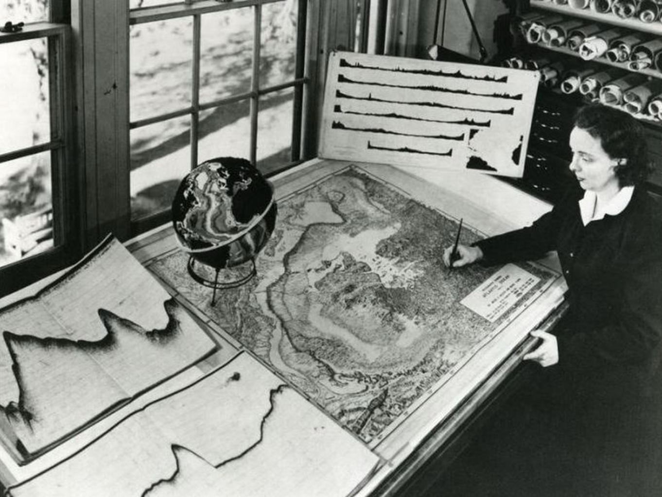
A young Marie Tharp at work, using hundreds of echo sounding profiles to map the topography of the ocean floor. Photo: Lamont-Doherty Earth Observatory.
At the same time, several male graduates, all of whom would go on to become well-known geoscientists, started working in the geophysics lab. Bruce Heezen became the chief scientist and ocean expedition leader, straight out of his undergraduate degree. Although Marie was more qualified, she was not considered for such a role, because of her gender, but instead assisted the male graduates with mathematical calculations, computations and the drafting of diagrams. Her detailed work and valuable contributions continued to go unacknowledged. In 1952, while her male colleagues were attending a conference, Marie left Columbia University to go to her father’s farm and think about the injustice of her situation. Her absence was felt strongly and highlighted the importance of the contribution she was making to Ewing’s team. In order to attract her back, Ewing eventually recognized that her work situation had to change. From thereon Marie worked solely with Bruce Heezen in a highly prolific collaboration that endured all of their lives.
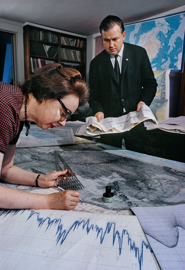
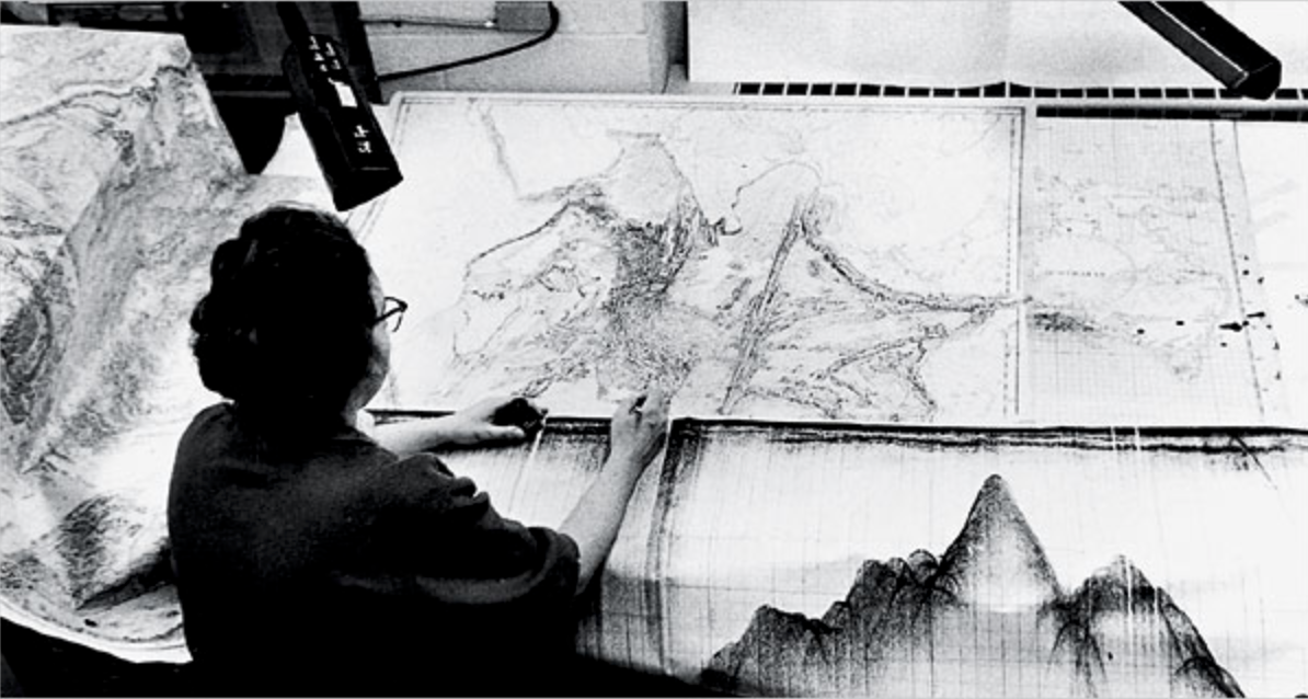
After processing the echo sounding data, Marie drew her maps with pencil and ink manually. Bruce Heezen standing in the background Photograph by Joe Covello, National Geographic.
Another barrier that Marie faced was that women were not allowed on ships, as this was considered bad luck up until the 1960s. Instead of going to sea, she stayed ashore and mapped the echo soundings collected by ships point by point. The state-of-the-art ‘echo sounding’ method used to chart the deep ocean worked by sending an electronic signal deep into the ocean, where it would reflect off the seafloor and be received by a microphone back on the ship. The time it took for the signal to return could be used to gauge ocean depth. It was Marie’s job to turn those numbers into a map, which required her to painstakingly plot the sounding profiles acquired by ships. She plotted six E-W profiles across the North Atlantic (up to 3500 km long). Her diligent and detailed work allowed her to examine the ocean’s bathymetry, which revealed that the bottom of the ocean was not a flat and featureless plane, but had a topographic fabric. In 1952, as the image of the bottom of the ocean was coming together, Marie’s maps revealed the presence of a continuous and symmetric feature, which she called ‘rift’. And this feature was present in other oceans. Initially, her colleague Bruce Heezen was skeptical, as the presence of such a rift would have supported Wegener’s controversial theory of continental drift and ridiculed Marie’s theory as ‘girl talk’. At the time, supporting the theory of continental drift was almost a form of scientific heresy.
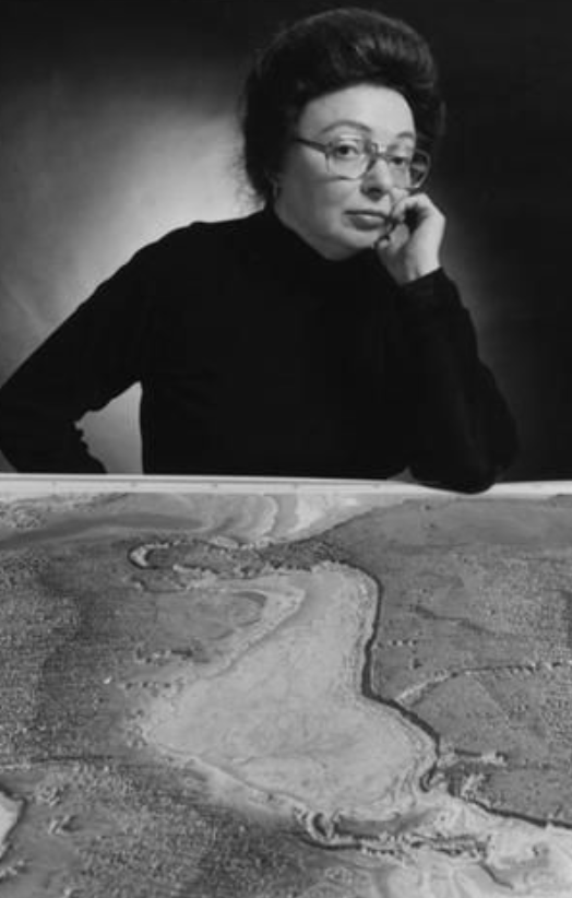
Marie Tharp posing with her map, coloured by Heinrich C. Berann, produced by National Geographic in 1968. Photo: Lamont-Doherty Earth Observatory and the estate of Marie Tharp.
But because all the data were plotted on maps of the same scale, these could be superimposed on a light table. And indeed: the earthquake epicenters lined up with the rift valleys, which provided further support for Marie’s rift valley. While Bruce was skeptical at first, he recognized the correlation between earthquakes and the rift valley and began to endorse the existence of a continuous central valley within the mid-oceanic ridge system. Further data from the South Atlantic supported the existence of an underwater mountain range with a central valley and it was becoming clear that this was a more or less a continuous feature across the face of the Earth. These findings were first presented to the scientific community in 1956, when Heezen and Ewing published and presented the evidence for the worldwide rift. The reactions from the scientific community spanned from amazement to scorn. Only three years later Marie was eventually included as a co-author on her own work when the text accompanying the physiographic map of the North Atlantic was published (Heezen, Tharp and Ewing, 1959). Their scientific maps visualized the topography of the ocean floor revealed that there is a whole geographical landscape of mid-ocean ridges, fracture zones and trenches down there.
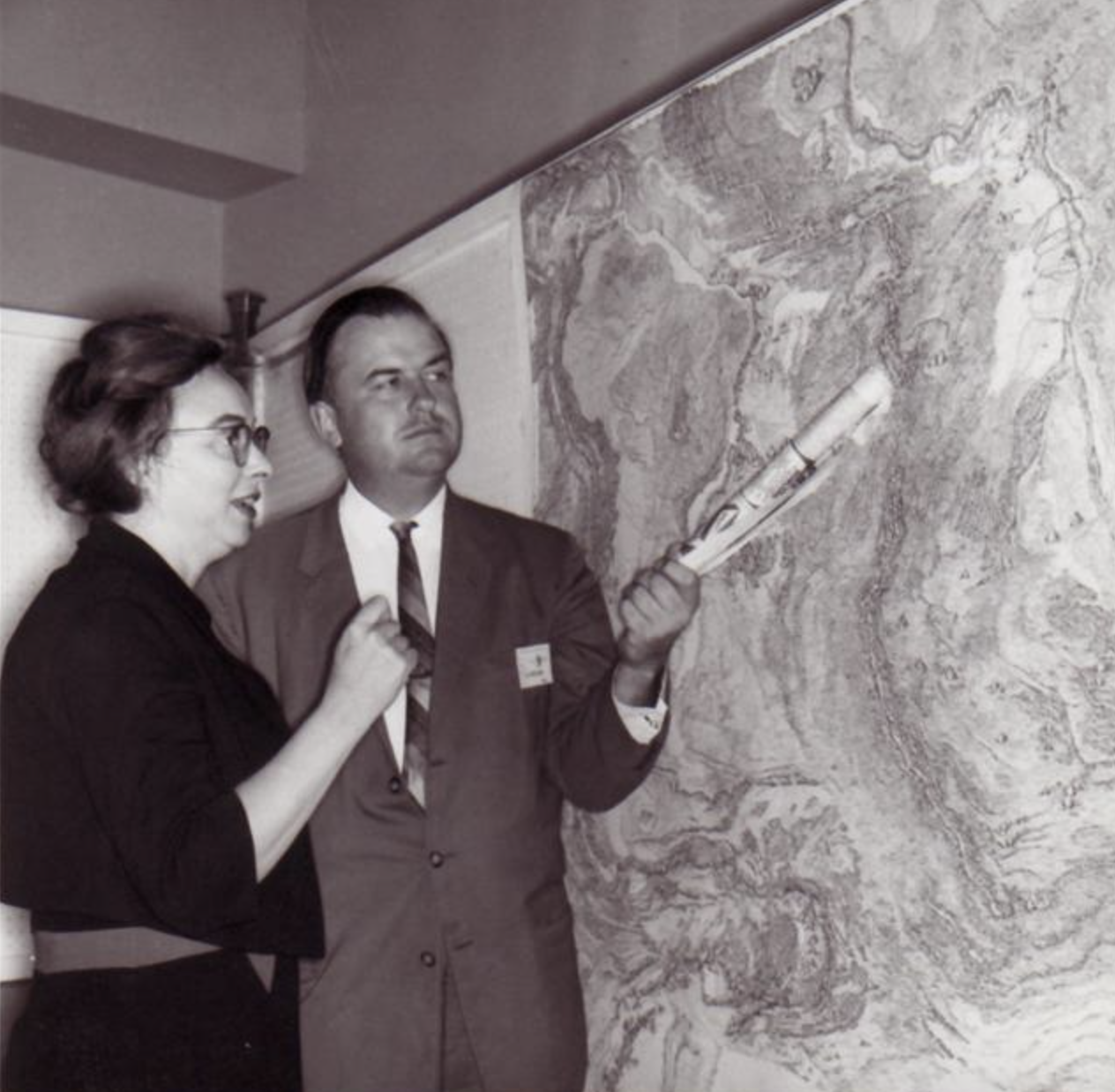
Marie Tharp and Bruce Heezen discussing the mid-oceanic ridge on Marie’s map Photo: from flickr.com.
For years to come, Bruce Heezen continued to collect data acquired by ships, while Marie crunched the numbers, combed through enormous piles of sonar soundings, plot out her measurements and charted them out as profiles by hand from one sounding to the next, and from one ocean to the next.
Marie Tharp at work, using hundreds of echo sounding profiles to map the topography of the ocean floor. Photo: Lamont-Doherty Earth Observatory.
While the scientific community at first refused to believe in the existence of the rift valley, Marie’s evidence was irrefutable. Marie’s hard work and attention to detail was instrumental to producing the first comprehensive map of the 70 percent of our planet’s surface that is obscured by water, and eventually mapped and established the existence of the single-largest geographic feature on the planet: mid-ocean ridges that span 40,000 miles in the world’s oceans. Connecting the dots not only led to the biggest discovery of her career, but also led to a paradigm shift in the Earth Sciences by promoting the acceptance of continental drift and seafloor spreading, the key components of plate tectonics.
Throughout her career as a scientist, Marie worked in the background. At one point in her career, she was even denied access to data collected by the Lamont Geological Observatory expeditions. For years Marie continued to work from her own home. Funding from the US Navy and the National Geographic magazine allowed the Tharp-Heezen ocean mapping initiative to continue its research and eventually led to the production of a series of ocean floor maps, which were made available to the public. Throughout the years, the challenges Marie faced were not only of scientific nature. Due to her gender, she only got to go to sea in 1965, when Heezen was chief scientist on the ‘Eastward’ – a ship owned by the National Science Foundation. In an era where female scientists were routinely dismissed as secretaries and used as human calculators, Marie’s sharp mind and quiet determination allowed her to make a wide impact. Her hard work and dedication changed the world from behind the scenes and laid the foundation for a revolution in Earth Sciences that led to the development of Plate Tectonic theory. Like most female scientists of the era, Marie Tharp was not recognized for her work until very late in her life. We can only imagine how differently the history of Earth Science would have evolved if Marie’s findings had been made known to the world in 1952 and if she had published them in her own name. Marie Tharp’s legacy continues to inspire generations of female earth scientists, driving them forth to explore every corner of the globe.
Written by Derya Gürer
Edited by Anouk Beniest and Hannah Davies
Literature
Heezen, B.C., Tharp, M., and Ewing, M., 1959, The Floors of the Oceans I. The North Atlantic: Geological Society of America Special Paper 65, 126 p., 30 plates.
Heezen, B.C., Tharp, M., 1965. Tectonic fabric of the Atlantic and Indian oceans and continental drift”. Philosophical Transactions of the Royal Society of London A. 258 (1088): 90–106.
Further Reading
Barton, C., 2002, Marie Tharp, oceanographic cartographer, and her contributions to the revolution in the earth sciences, in Oldroyd, D., ed., The Earth Inside and Out: Some Major Contributions to Geology in the Twentieth Century: Geological Society, London, Special Publication 192, p. 215–228.
Felt, H., 2012, Soundings: The Story of the Remarkable Woman Who Mapped the Ocean Floor: New York, Henry Holt & Company, 368 p.
Higgs, B.M., 2020. Understanding the Earth: the contribution of Marie Tharp. Geological Society, London, Special Publications, 506.
Tharp, M., 1999, Connect the dots: Mapping the seafloor and discovering the mid-ocean ridge, in Lamont-Doherty Earth Observatory of Columbia University: Twelve Perspectives on the First Fifty Years 1949–1999, p. 31–37, (https://www.whoi.edu/news-insights/content/marie-tharp/?pid=7500&tid=7342&cid=23306, last accessed July 30, 2020)
Mason, B., How one brilliant woman mapped the secrets of the ocean floor, https://www.nationalgeographic.com/news/2017/02/marie-tharp-map-ocean-floor/ (last accessed July 30, 2020)
O’Connell, S., (2020), Marie Tharp pioneered mapping the bottom of the ocean 6 decades ago – scientists are still learning about Earth’s last frontier , The Conversation https://theconversation.com/marie-tharp-pioneered-mapping-the-bottom-of-the-ocean-6-decades-ago-scientists-are-still-learning-about-earths-last-frontier-142451 (last accessed July 30, 2020)
Series of ‘Oral History Interviews’ (1995-1997) with Marie Tharp: https://www.aip.org/history-programs/niels-bohr-library/oral-histories/22896-1
Children’s Books
Burleigh, R., 2016. Solving the puzzle under the sea: Marie Tharp maps the ocean floor. Simon and Schuster.
Bush, E., 2020. Ocean Speaks: How Marie Tharp Revealed the Ocean’s Biggest Secret by Jess Keating. Bulletin of the Center for Children’s Books, 73(11), pp. 480-480.
SRINIVAS rao
I am very glad to know about the legendary female scientist (Mary thorpe) and her contributions an identifying the mid-oceanic ridge system,
Thanks to Derya Gürer.
Dr. H. S. M. Prakash
Hearty tributes to her for her lasting contributions to Earth Sciences.
Natacha
As a female minority geoscientist, I am thrilled to learn about Marie Tharpe worked in the field of geology. We still have a long way to go.