Do ancient structures control present earthquakes in the East African Rift?
Åke Fagereng, Reader in Structural Geology, School of Earth and Ocean Sciences, Cardiff University
For this edition of Minds over Methods, we have invited Åke Fagereng, reader in Structural Geology at the School of Earth and Ocean Sciences, Cardiff University. Åke writes about faults in the Malawi rift, and the seismic hazard they may represent. With his co-workers from the Universities of Cardiff, Bristol, and Cape Town, the Malawi Geological Survey Department, Chancellor’s College, and the Malawi University of Science and Technology, he has studied these faults in the field and in satellite imagery. Their methods span scales of observation from outcrop to rift valley, allowing insights on how rifts and rift-related faults grow.

Åke Fagereng looking at rocks by Lake Malawi. Credit: Johann Diener.
Introduction
East Africa hosts some of the longest faults on the continents, yet it is not a well-known location for significant seismic hazard. There is, however, historical record of large earthquakes (> M7; Ambraseys, 1991), and topographic evidence for major scarps (Jackson and Blenkinsop, 1997), so we ask where, and of what magnitude, could future earthquakes occur?
The instrumental record of East African earthquakes is short, and sparse instrumentation only detects moderate to large magnitude events. Recent, seismic deployments have, however, made great progress in understanding active seismicity in the southern East African rift (e.g. Gaherty et al., 2019; Lavayssière et al., 2019). Such studies have demonstrated that the seismogenic thickness – the depth range where earthquakes nucleate – spans the entire crust (up to 40 km depth). This large seismogenic thickness is important; it theoretically means that ~ 100 km long border faults could rupture along their entire length and throughout the thickness of the crust, creating > M8 earthquakes. Such events would have severe impact, particularly given rapid population growth, urbanization, and high vulnerability of the East African building stock (Goda et al., 2016).
There is a scale dependence to fault observations in rifts. On the rift valley scale, active extension broadly follows ancient plate boundaries marked by deformed, metamorphic rocks separating ancient continental building blocks of cratons and shields. However, does the same observation apply to individual faults, and at what depths? Is there evidence for large earthquake events? A hypothesis to test is whether ancient structures control the location and geometry of major rift border faults, and allow them to be long and continuous.
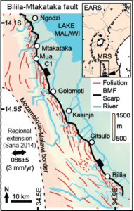
The Bilila-Mtakataka fault in Malawi (black), broadly following but locally cross-cutting foliations (red). Map reproduced after Hodge et al. (2018).
Methods and Results
In the PREPARE project, we focus on Malawi as a case study in the southern, non-volcanic, portion of the rift. Although we have established a network of campaign GPS stations, slow extension rates (< 3.5 mm/yr; Saria et al., 2014) imply that reliable geodetic data will take several more years to collect. Similarly, long earthquake recurrence times lead to a question of how representative the instrumental record can be. Therefore, we have explored other methods for understanding fault scarps and the likely behavior of their faults.
In his PhD work, Michael Hodge used a combination of data sets, including satellite imagery and digital elevation models, photogrammetry, and field observations to analyse the major Bilila-Mtakataka fault from outcrop to rift scale. This fault sits within an ancient ‘mobile belt’ and follows these structures in some places, but cross cuts them in others (Hodge et al., 2018). These observations show that the fault only exploited near-surface ancient structures where these were very well oriented for failure, while elsewhere the fault would take another orientation.
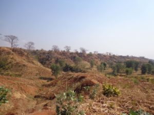
The Bilila-Mtakataka fault, illustrated by its ~ 10 m high scarp. Credit: Åke Fagereng.
To better understand the controls on fault reactivation and how our surface observations relate to faulting at depth, we place our field and satellite observations in a framework of fault mechanics. It is not uncommon that normal fault segments take two strike orientations: one parallel to pre-existing weaknesses, the other perpendicular to the extension direction (e.g. McClay and Khalil, 1998). However, although there is uncertainty around local extension directions, where fault segments in Malawi cross-cut ancient structures they do not seem to have a consistent, extension-perpendicular, strike (Hodge et al., 2018).
Hodge et al. (2018) tested whether a mid- to lower crustal ancient structure could control the average orientation of the Bilila-Mtakataka surface scarp. This test was based on whether model predictions fitted detailed measurements of scarp height and orientation using a digital elevation model. Such measurements are time consuming, but using a semi-automated method, can also be applied efficiently at the scale of multiple faults (Hodge et al., 2019). Here, the model supports a conclusion where long fault scarps form above localized, deep crustal structures, that are locally deflected near the surface. This model allows the long scarps to have formed in multiple smaller earthquakes rather than a single very big one.
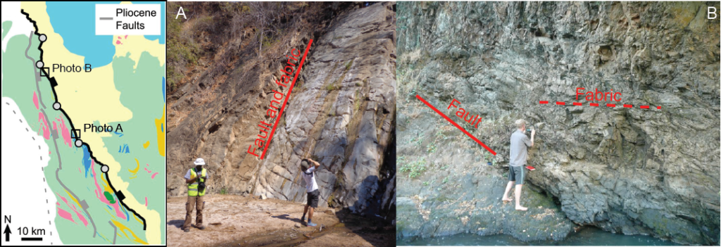
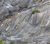
Field observations of the Bilila-Mtakataka fault, which locally parallels (A) and locally cross cuts foliation (B). Map from Hodge et al. (2018), Michael Hodge and Hassan Mdala study the fault in A (credit Åke Fagereng) and Åke Fagereng measures a fracture in B (credit Johann Diener).
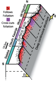
Model, simplified from Hodge et al. (2018), showing how upward propagation of a deep structure is consistent with a segmented surface trace, if the fault is deflected by well-oriented foliation locally and near –surface.
Future Work
Newly discovered fault scarps within the Zomba graben, further south in Malawi, furthermore show that fault orientations vary on the scale of multiple faults within a graben. Here, strike variations also lack a clear fit to expected orientations inferred from the rift-wide extension direction. Ongoing studies are now employing similar methods to analyze the relation between fault geometry and pre-existing structures in the field, on the scale of a complete graben, further bridging the outcrop and rift scales.
Geophysical and remote sensing approaches have been and continue to be invaluable to understand the regional and subsurface structure of the East African and other continental rifts. We emphasise, however, that fault scale structural observations aid interpretation of these data and allow deduction of fault growth mechanisms. Our methods in future work will therefore continue to span scales, and root interpretation in detailed fault-scale field studies linked to rift-scale satellite data.
Edited by Elenora van Rijsingen
References
- Ambraseys, N.N., 1991. The Rukwa earthquake of 13 December 1910 in East Africa. Terra Nova 3, 202-211.
- Gaherty, J.B., Zheng, W., Shillington, D.J., Pritchard, M.E., Henderson, S.T., Chindandali, P.R.N., Mdala, H., Shuler, A., Lindsey, N., Oliva, S.J. and Nooner, S., 2019. Faulting processes during early-stage rifting: seismic and geodetic analysis of the 2009–2010 Northern Malawi earthquake sequence. Geophysical Journal International 217, 1767-1782.
- Goda, K., Gibson, E. D., Smith, H. R., Biggs, J., & Hodge, M. (2016). Seismic risk assessment of urban and rural settlements around Lake Malawi. Frontiers in Built Environment, 2, 30.
- Hodge, M., Fagereng, Å., Biggs, J. and Mdala, H., 2018. Controls on early‐rift geometry: new perspectives from the Bilila‐Mtakataka fault, Malawi. Geophysical Research Letters 45, 3896-3905.
- Hodge, M., Biggs, J., Fagereng, Å., Elliott, A., Mdala, H. and Mphepo, F., 2019. A semi-automated algorithm to quantify scarp morphology (SPARTA): application to normal faults in southern Malawi. Solid Earth 10, 27-57.
- Jackson, J. and Blenkinsop, T., 1997. The Bilila‐Mtakataka fault in Malaŵi: An active, 100‐km long, normal fault segment in thick seismogenic crust. Tectonics 16, 137-150.
- Lavayssière, A., Drooff, C., Ebinger, C., Gallacher, R., Illsley‐Kemp, F., Oliva, S.J. and Keir, D., 2019. Depth extent and kinematics of faulting in the southern Tanganyika Rift, Africa. Tectonics 38, 842– 862.
- McClay, K. and Khalil, S..1998. Extensional hard linkages, eastern Gulf of Suez, Egypt. Geology 26, 563–566
- Saria, E., Calais, E., Stamps, D.S., Delvaux, D. and Hartnady, C.J.H., 2014. Present‐day kinematics of the East African Rift. Journal of Geophysical Research 119, 3584-3600.