San Francisco has been a natural gathering place for people across the millennia. It is not a coincidence that this city, situated at the entrance to the largest estuary on the U.S. West Coast, owes its dramatic setting to active geology on the North American plate margin. The first people of the San Francisco Peninsula, the Ramaytush Ohlone, cared for the land here for thousands of years before European arrival. They lived comfortably in a network of small villages where their life centered on tending the natural world, family, and community.
In 1776 Spanish soldiers and colonists of the Juan Batista de Anza Expedition ushered in European colonization. The great harbor of San Francisco Bay, which Europeans had first seen only seven years earlier, attracted them to this site. The Spanish built a Catholic mission and presidio (fort) and established the pueblo of Yerba Buena. All the Ramaytush Ohlone were moved to the Spanish mission where they worked and were indoctrinated into Catholicism. By 1801, about eighty percent had died from disease, hunger, and poor working conditions.
Spain lost its California territory to Mexico in 1822, and the United States took control in 1846 during the Mexican American War. Two years later, gold was discovered in the Sierra foothills, and the sleepy village of Yerba Buena was transformed into the bustling city of San Francisco. Gold seekers, known as 49ers, arrived from around the world to find their fortune, and San Francisco became a major center of commerce and the West Coast’s largest city for decades to come.
At the time of the gold rush, much of the San Francisco Peninsula was covered by one of the largest sand dune fields on the West Coast (Figure 1). The city grew to cover almost the entire dune field, and the bay shore and nearby shallow lakes were filled to create new land on which to build.
What geological stories lie behind the creation of this magnificent bay and the city by its shore?
In this blog, we will read the rocks of the land surrounding San Francisco Bay, known as the Bay Area, to tell a story of active tectonism at the North American Plate margin that extends back 200 million years. A geological history that resulted in the landforms that have attracted people to the site of this great “City by the Bay”. These landforms include coasts with abundant marine and terrestrial resources, a sheltered deep-water harbor, hills and mountains with plentiful forests, and streams and rivers providing water and transportation routes, including to the goldfields of the Sierra Nevada Mountains.
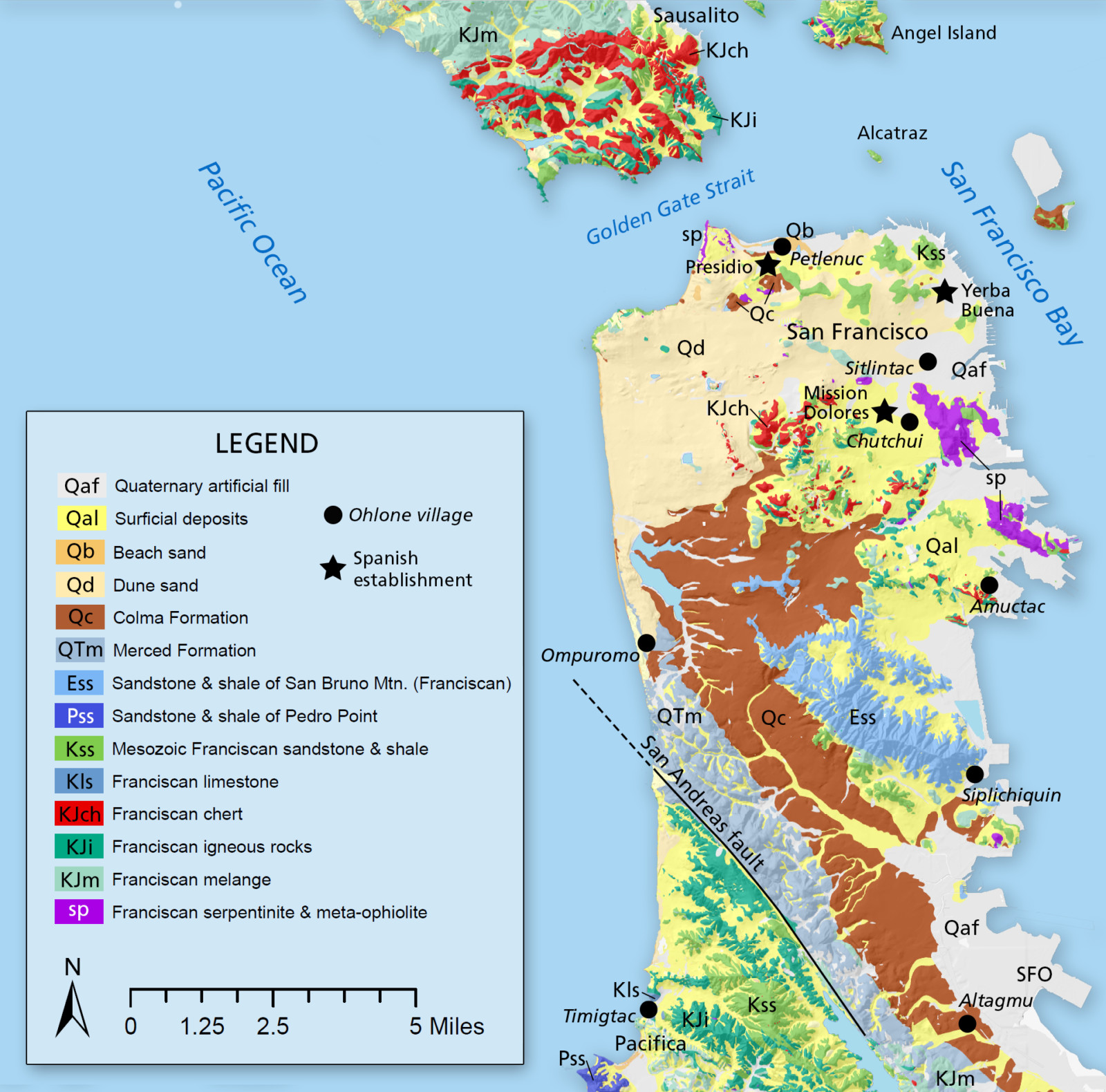
Figure 1 – Simplified geological map of San Francisco Peninsula showing locations of Indigenous People’s villages, Spanish establishments, and modern cities. Credit: William Elder.
Subduction and the Franciscan Complex – The Geologic Underpinning
The basement rocks of coastal California are largely made of pieces of Pacific seafloor (Farallon or Kula plates) that were added to the continental margin as the ocean crust was subducted (moved) beneath the western edge of North America. The distinctive rocks of the world-famous Franciscan Complex, named in San Francisco and underlying much of coastal Northern California east of today’s San Andreas Fault, formed in this subduction zone. Locally, Franciscan rocks range in age from about 200 Ma to 50 Ma.
Franciscan rocks include igneous seafloor and marine sedimentary rocks that have been divided into coherent terrane blocks (Figure 2) that were pieces seafloor added to the plate margin rather than being subducted beneath it. Zones of mélange (mainly a mixture of seafloor rocks and mantle derived serpentinite) separate the terranes. In the Bay Area, the Franciscan Complex is divided into eight terranes based on igneous basement types and ages, the age and types of overlying sedimentary sequences, and the metamorphic grade of the blocks. In general, the terranes are tectonically stacked with the oldest to the east, but higher in the stack due to tectonic underplating.
Four of these terranes underlie San Francisco: the Alcatraz, Marin Headlands, Bolinas Ridge, and San Bruno Mountain terranes. Separating the terranes are the Hunters Point and City College mélange zones. The Alcatraz Terrane is mostly sandstone deposited by submarine landslides and contains several Cretaceous mollusks found on Alcatraz Island. Detrital zircons from these sandstones are as young as 95 Ma (Late Cretaceous). The Marin Headlands Terrane contains a variety of oceanic rock types, including basaltic seafloor crust (often altered to greenstone), open-ocean ribbon cherts, and continental-derived turbidite sandstones (Figure 3). Radiolarian fossils indicate that the cherts were deposited between about 100 Ma to 200 Ma (Early Jurassic to Late Cretaceous). Rare ammonites in the sandstones indicate an age between 98 Ma and 105 Ma, which is consistent with youngest detrital zircon dates. The San Bruno Mountain Terrane is predominately turbidite sandstone and has yielded no fossils. It has produced detrital zircon ages as young as 52 Ma (Eocene). Turbidite sandstones near Lands End have yielded no fossils, but lithology and detrital zircons as young as 86 Ma (Late Cretaceous), suggest this block formerly assigned to the San Bruno Mountain terrane belongs to a newly defined Bolinas Ridge terrane.
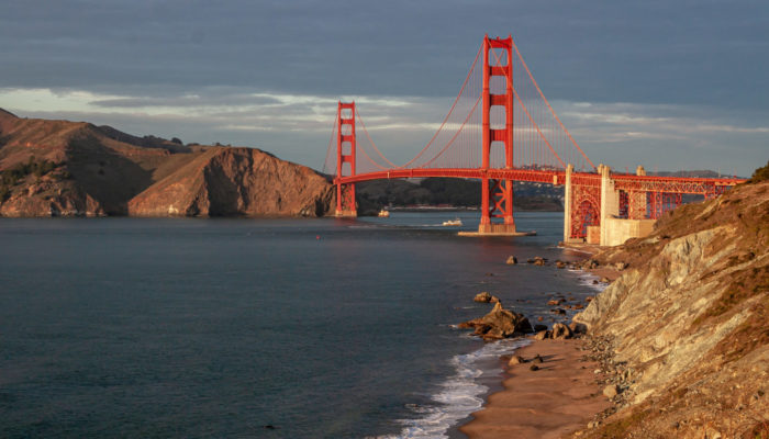
These Franciscan basement rocks form the geologic underpinning of San Francisco (Figure 1). Today, visitors to San Francisco can explore the rocks of these terranes on public lands at sites in Golden Gate National Recreation Area (GGNRA), including the Marin Headlands just north of the Golden Gate Bridge, where there are also fantastic views of the bridge and city, the Alcatraz terrane on Alcatraz and at Fort Mason, and the Bolinas Ridge terrane at Lands End, which also provides great views of the open coast.
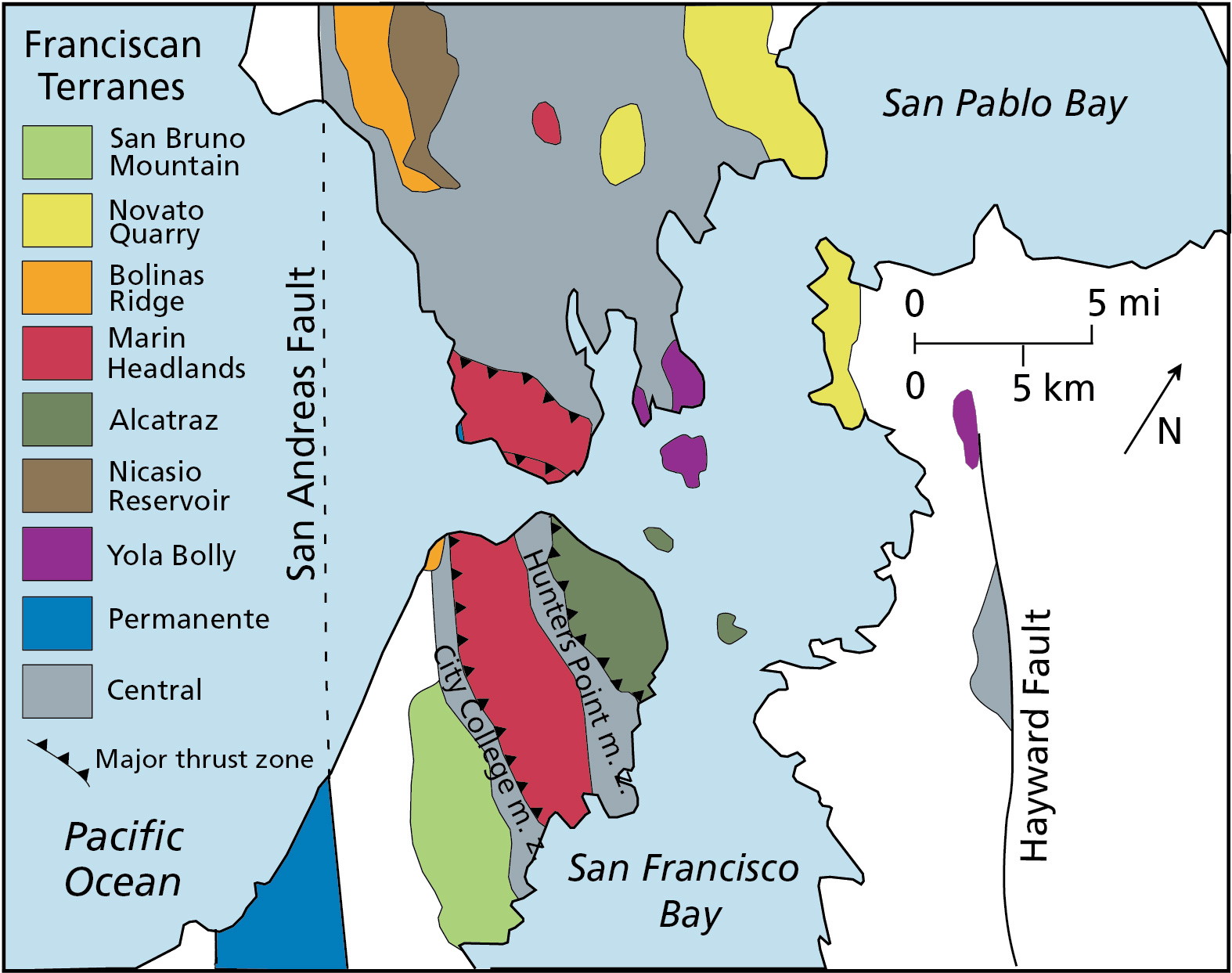
Figure 2 – Franciscan terrane map of San Francisco Bay Area (updated from Blake et al., 1984).
Transform Faulting and the San Andreas – Creating the Modern Pacific Margin
Today the North American/Pacific plate boundary where San Francisco is located is a right lateral transform boundary (the plates are sliding past each other), forming what is perhaps the best-known geologic feature of California, the San Andreas fault zone. The San Andreas is a relatively new feature, originating in Southern California only 28 million years ago when the East Pacific Rise started to subduct under the North American Plate. The fault system extended northward, passing through the Bay Area about 10 Ma to 6 Ma. Local movement along the San Andreas totals around 2.5 cm a year. The San Andreas and local subsidiary faults, the Hayward and Calaveras, are infamous for producing large earthquakes that periodically rock San Francisco. Major earthquakes on these, or less well-known faults in the Bay Area, release strain between the creeping plates several times each century. This ongoing tectonism also results in the area’s youthful and beautifully rugged terrain of the California Coast Ranges.
The mountains that surround San Francisco are the result of tectonic deformation that started between about 7 Ma to 4 Ma, when compression across the San Andreas fault system increased, probably in association with a shift in relative plate motions. Tectonic blocks in the Bay Area started to respond differently to the compression, some uplifting and others staying stable or down-dropping. The Santa Cruz Mountain block (Figure 4) is still uplifting at a left bend in the San Andreas fault. This restraining bend produces folding and thrust faulting; up to 59 cm of uplift occurred in the Santa Cruz Mountains during the 1989 Loma Prieta earthquake. Today, the San Francisco Bay block lies in a stable or slowly subsiding area between the San Andreas, Hayward, and Calaveras faults.
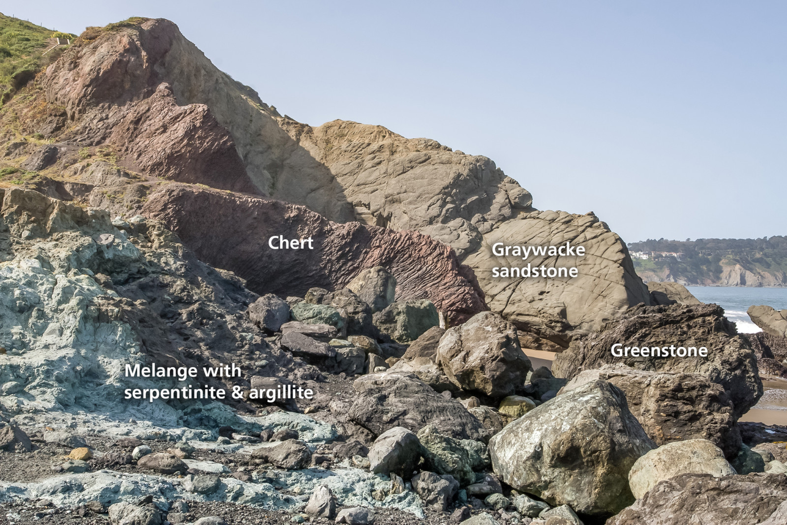
Figure 3 – Typical rocks of the Franciscan Complex in mélange zone where Marin Headlands terrane come onshore at Baker Beach, San Francisco. Credit: William Elder.
San Andreas Basinal Infilling – The Merced Formation
The Pliocene and Pleistocene Merced Formation occurs along the east side of the San Andreas fault and marks the first post Eocene deposition preserved on the San Francisco Bay block. The Merced may reflect deposition in a transtensional basin developed behind a right stepover between the San Andreas and Golden Gate faults (Figure 5), and its sediments record repeated sea level changes related to Pleistocene glacial periods. Merced sediments older than about 640 Ka, contain only locally derived material. Younger sediments contain volcanic rock fragments and minerals from the Sierra Nevada and southern Cascade Range, indicating initiation of the modern Sacramento/San Joaquin River system, which flowed from the Central Valley through the San Francisco Valley to the ocean. Today, visitors can inspect these sediments and see the effects of glacial sea level changes in Merced rocks in GGNRA along the sea cliffs at Fort Funston.
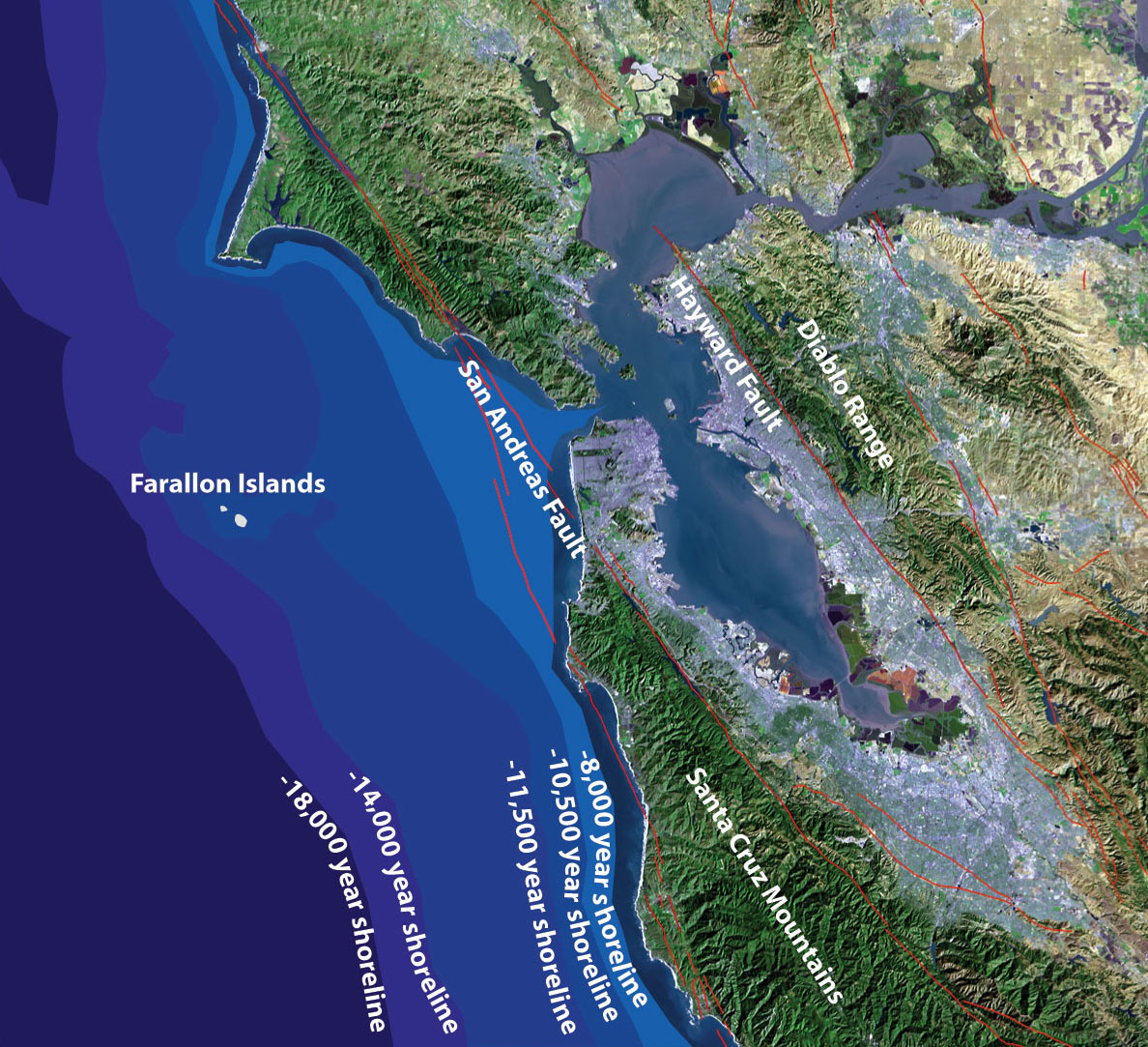
Figure 4 – Satellite image of San Francisco Bay Area showing major faults, geographic features, and shoreline positions after the last glacial (modified from USGS and PG&E image).
Making San Francisco Bay
The valley in which San Francisco Bay resides began to form 3 Ma to 2 Ma, when the surrounding mountains and hills uplifted on either side. The first known estuarine (marine influenced) rocks were laid down about 600 Ka. Rocks under the bay indicate up to seven estuarine-terrestrial cycles over the last half million years, corresponding to glacial eustatic sea level changes. During glacial periods, when vast quantities of ocean water were stored in continental glaciers, the bay floor became a valley and experienced erosion and downcutting. At those times, the glacial-fed ancestral Sacramento River flowed out the Golden Gate Straits to a shoreline at the edge of the continental shelf, 40 km to the west (Figure 4). During the last interglacial highstand (ca. 125 Ka), marine and marginal marine deposits of the Colma Formation blanketed much of the San Francisco Peninsula (Figure 1). As the sea rose after the last glacial maximum, starting 18 Ka, it flooded across the shelf, and sand was blown from the migrating shoreline eastward to form the dune field that underlies San Francisco today. Ocean water started flooding the present San Francisco Bay about 8 Ka and has remained relatively stable for the last 5,000 years.
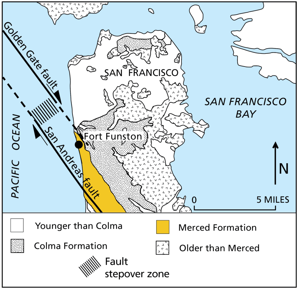
Figure 5 – Map showing Merced Formation and nearby left offset in San Andreas fault (modified from unpublished U.S. Geological Survey poster).
San Francisco Today and into the Future
Today, San Francisco is a thriving city of 850,000 people within a few miles of the San Andreas fault and other nearby active strands of the transform system. During the 1989 Loma Prieta earthquake, areas of the city built on thick dune deposits, like the Sunset District, and bay fill, like the Marina District, were preferentially damaged due to liquefaction and amplified shaking over poorly compacted sediments. Updated building codes and improved construction techniques will help address these issues. Another threat is sea level rise due to global warming, with low-lying areas, including downtown and on the coast near Ocean Beach, being of special concern. Plans for addressing and adapting to future flooding and erosion are in development.
The public lands of GGNRA allow visitors to explore many geologically significant sites in the area. The park is also actively restoring remnant habitats to bring back some of the high biodiversity that was once present in the city’s dune and serpentine soil habitats. We invite all to come to the park and learn about San Francisco’s past, present and future.
Written by William Elder, Ph.D.
National Park Service, Golden Gate National Recreation Area
Edited by Elenora van Rijsingen
To learn more visit:
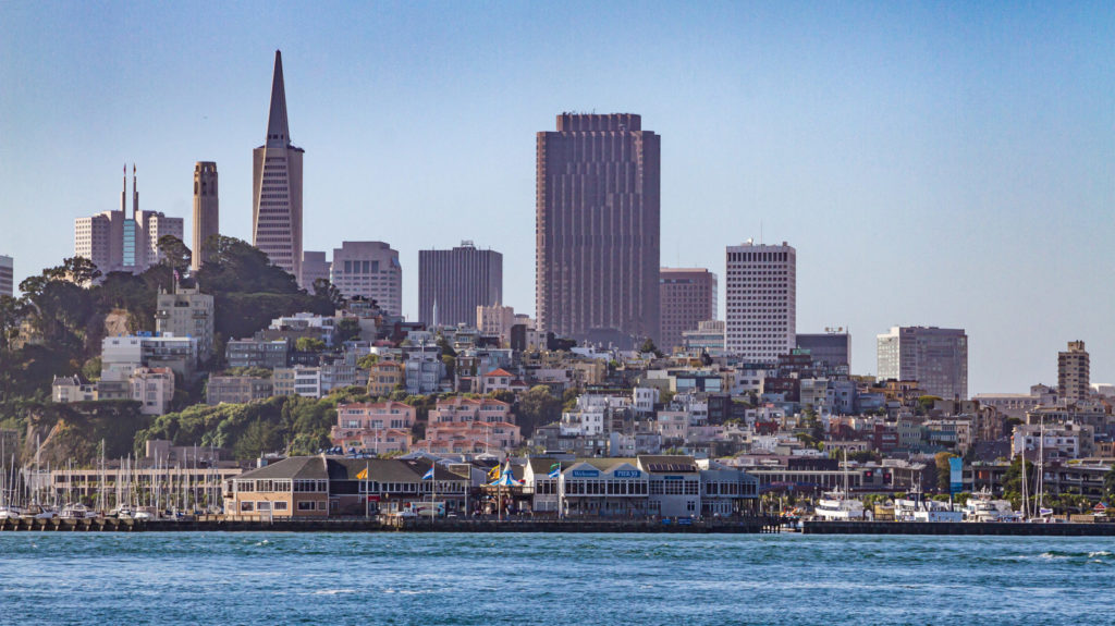
San Francisco’s skyline seen from the Alcatraz shuttle in the bay, with landmark buildings like Coit Tower, the Trans America Pyramid and the Bank of America building. Credit: William Elder.

Michael Macko
Excellent summary of the peninsula’s geologic history and structure. Do you have references to the information on Ramaytush Ohlone villages?