
On 23rd February 2026, Malaysia faced one of the strongest earthquakes ever recorded in its history. A magnitude 6.8 event struck offshore Sabah, the most seismically active state in Malaysia. The event was reported as magnitude 6.8 by MetMalaysia, while the USGS recorded it as magnitude 7.1, with the difference reflecting variations in magnitude estimates between agencies. However, it was not catastrophic, instead it passed with little to no damage. Why was that? Simply because the earthquake occurred at a depth of 678 km. For the public, it raised an immediate question. How could such a massive release of energy leave us largely unscathed, and what happens if the next one strikes at a shallower depth beneath a populated area? For geoscientists, the answer lies almost 700 kilometers beneath our feet. This makes the deep rupture a fascinating case study. In this post, I explore the February 2026 Sabah earthquake and examine how its exceptional depth influenced the shaking experienced at the surface.
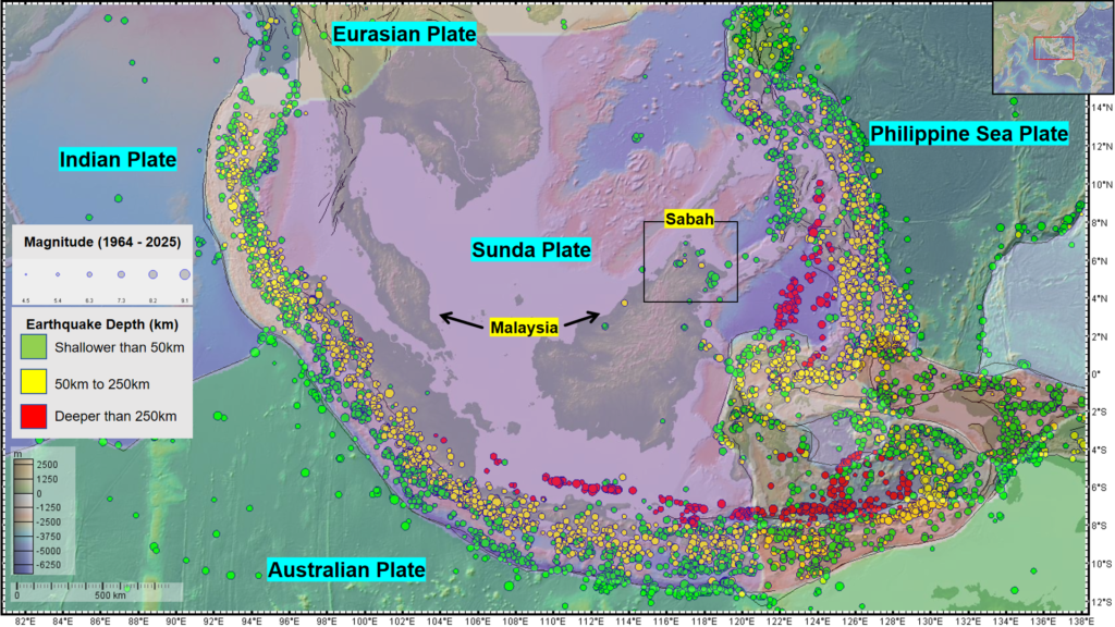
Figure 1. Distribution of seismicity and location of Malaysia in Southeast Asia. The earthquake data was obtained from the International Seismological Centre (Image Credit: Navakanesh M Batmanathan).
It was large, but it was very far away
When we talk about earthquakes, we often focus on magnitude. A magnitude 6 earthquake sounds serious, and a magnitude 7 sounds even more serious. But magnitude is only part of the story. One of the things I find particularly interesting about earthquakes is that where they happen can be just as important as how large they are (Fig. 1).
Think about tapping a table. If you tap the surface directly underneath your hand, you immediately feel the vibration. Now imagine producing the same disturbance at the base of a table leg, with the vibration travelling up through the solid material of the table. The energy still exists, but by the time it reaches the tabletop, it has travelled through a large amount of material and spread out along the way. The same basic idea helps us understand the Sabah earthquake.
The earthquake did not happen a few kilometres below the ground. Its source was more than 600 km deep (Fig. 2). That means the seismic waves generated by the earthquake had to travel through hundreds of kilometres of Earth’s interior before they could reach us. By the time they arrived at the surface, much of the energy had been spread out and attenuated. This is one of the main reasons why the earthquake could be large without producing the kind of strong, damaging shaking we might expect from a similarly sized shallow earthquake.
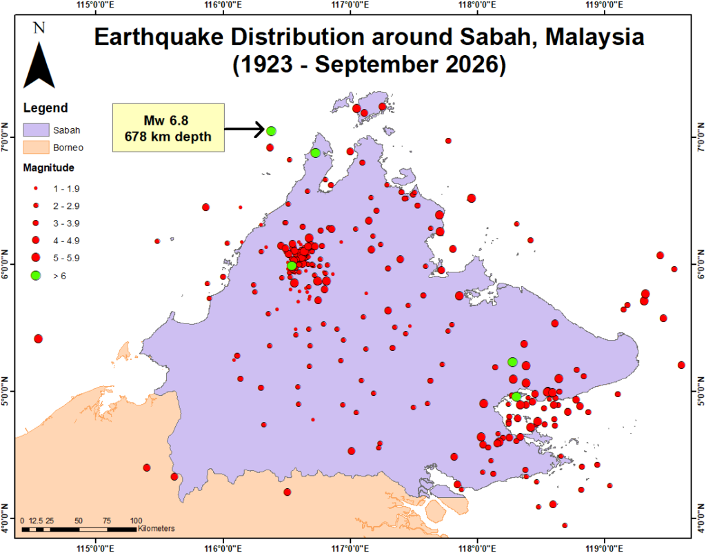
Figure 2. The location of the Mw 6.8 earthquake within Sabah, Malaysia. The earthquake datasets were derived from MyGempa. (Image Credit: Navakanesh M Batmanathan)
What happens to the seismic wave?
When an earthquake occurs, energy is released in the form of seismic waves. These waves travel through the Earth and can eventually reach the surface. The further they travel, the more their energy becomes distributed. As seismic waves travel through the Earth’s interior, some of their energy is gradually lost. The amount depends on the type of wave, its frequency and the materials through which it travels [1,2]. This is particularly important for deep earthquakes. A shallow earthquake can send strong seismic waves to the surface over a relatively short distance. A deep earthquake has a much longer journey. In the case of the February 2026 earthquake, the waves travelled through hundreds of kilometres of mantle before reaching the surface. That long journey helps explain why people could feel the earthquake over a wide area and experience relatively gentle movement rather than severe shaking.
Why was the earthquake so deep?
This is where the story becomes even more interesting. At first glance, Malaysia might not seem like a place where we should expect earthquakes of this size/magnitude. Much of the country is located within the relatively stable interior of the Sunda Plate [6]. But Sabah is different. Northern Borneo sits within a much more complicated tectonic setting, surrounded by several active and formerly active tectonic systems.
The February 2026 earthquake occurred far below the surface, in a part of the Earth where the rocks are subjected to enormous pressure and temperature. At depths of several hundred kilometres, the Earth behaves very differently from the shallow crust where most of the earthquakes we experience occur (Fig. 3). The earthquake is thought to be associated with a deeper, subducted slab of oceanic lithosphere beneath the region [4]. In simple terms, pieces of old oceanic crust can descend into the Earth’s mantle and remain there as they continue moving deeper into the planet.
These slabs can carry stresses and unusual temperature conditions with them. Eventually, those conditions can contribute to earthquakes at depths where ordinary shallow-crustal faulting works very differently. For us at the surface, all we see is the arrival of seismic waves. Deep beneath us, however, the earthquake is telling us something about how the Earth’s interior is behaving.
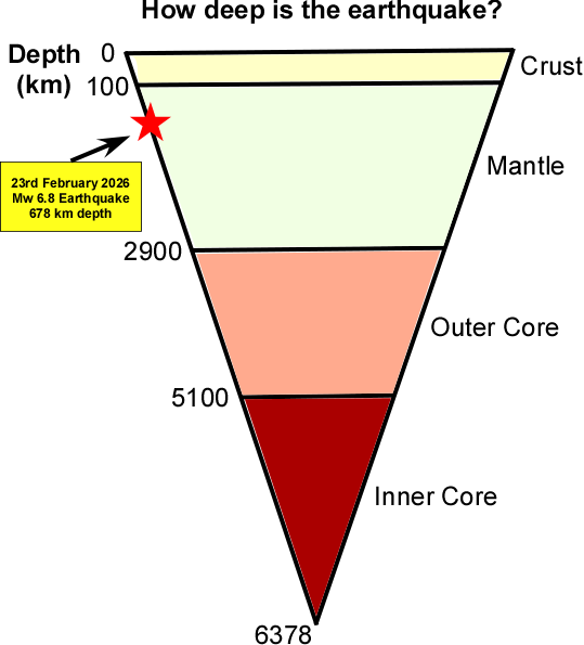
Figure 3. The earthquake originated at a depth of approximately 678 km, within the Earth’s mantle. The simplified cross-section (not to scale) illustrates the relative positions of Earth’s major internal layers and shows how deep the earthquake occurred beneath the surface (Image Credit: Navakanesh M Batmanathan)
Why didn’t it produce a tsunami?
Another question that came up after the earthquake was whether there was a tsunami threat.
The answer was no.
According to USGS, tsunamis typically consist of multiple waves that rush ashore like a fast-rising tide with powerful currents [5]. One of the most important ways this can happen is through significant vertical movement of the seafloor during a shallow submarine earthquake. The February 2026 earthquake was completely different. Its source was more than 600 km below the Earth’s surface.
The rupture therefore occurred far too deep to directly produce the kind of seafloor displacement normally associated with tsunami generation. This was another reason why the earthquake, despite its large magnitude, did not translate into a major coastal hazard.
Why should we still pay attention?
It would be easy to look at this earthquake and conclude that a magnitude 6.8 event is not necessarily something to worry about in Sabah. I don’t think that it is the lesson we should take from it.
The important lesson is that earthquake magnitude by itself does not tell us the whole story. Depth matters. Distance matters. The geological conditions beneath a location matter. And, of course, the vulnerability of buildings and infrastructure matters.
Sabah has experienced this difference before. In 2015, a magnitude 6.0 earthquake struck near Ranau at a much shallower depth. That earthquake caused extensive landslides around Mount Kinabalu and resulted in 18 deaths [3]. The comparison is striking. The 2026 earthquake was stronger, but it occurred hundreds of kilometres deeper. The 2015 earthquake was smaller, but it occurred close to the surface. The two earthquakes remind us that a bigger number does not automatically mean a bigger disaster.
So, are we safe?
That is perhaps the question I found myself thinking about after this earthquake.
The answer depends on what we mean by “safe.”
The February 2026 earthquake caused relatively little damage because its source was extraordinarily deep. The hundreds of kilometres between the earthquake and the surface made a huge difference. However, the shaking experienced at the surface also depends on local geology and ground conditions, which can amplify or reduce the effects of an earthquake. But we should not assume that the same would happen if a similar-sized earthquake occurred much closer to the surface.
For Sabah, this distinction is important. The region has a complex tectonic history and active geological structures. Understanding where earthquakes occur, how deep they are and how seismic waves behave as they travel through the region is therefore essential for understanding future earthquake hazards. The February 2026 earthquake did not give us a reason to ignore the earthquake hazard. Instead, it gave us a very good reason to understand it better.
References
[1] Chen, W., Wei, S. & Wang, W. Subslab ultra low velocity anomaly uncovered by and facilitating the largest deep earthquake. Nat Commun 15, 2754 (2024). https://doi.org/10.1038/s41467-024-47129-3
[2] Cui, X., Li, Z. & Hu, Y. Similar seismic moment release process for shallow and deep earthquakes. Nat. Geosci. 16, 454–460 (2023). https://doi.org/10.1038/s41561-023-01176-5
[3] Navakanesh B, Shah AA and Prasanna MV (2019) Earthquake Education Through the Use of Documentary Movies. Front. Earth Sci. 7:42. doi: 10.3389/feart.2019.00042
[4] Sahari, S., Ahmad Shah, A., Aaisyah, D., Batmanathan, N., & Shahbuddin, A. (2023). Active detachment faulting controls folding and faulting in western Borneo, SE Asia. Journal of Asian Earth Sciences: X, 9, 100133. https://doi.org/10.1016/j.jaesx.2022.100133
[5] USGS. (2017). What are Tsunamis? Usgs.Gov. https://www.usgs.gov/faqs/what-are-tsunamis
[6] Wang, Y., Wei, S., Wang, X. et al. The 2015 M w 6.0 Mt. Kinabalu earthquake: an infrequent fault rupture within the Crocker fault system of East Malaysia. Geosci. Lett. 4, 6 (2017). https://doi.org/10.1186/s40562-017-0072-9
Edited by: Hedieh Soltanpour & Harriet Thompson