
Subsea pipelines and cables are vital to modern energy and communications, yet assessing the active geological faults they cross underwater is notoriously difficult. By examining marine fault slip rates at higher stratigraphic resolution than previously analyzed in this region, our new research shows that displacement rates accelerated tenfold after the Last Glacial Maximum (LGM). This reveals that traditional, long-term hazard estimates may significantly underestimate the risk to seafloor infrastructure.
Subsea Infrastructure and Offshore Fault Hazards
When engineers construct critical facilities on land, such as power plants, bridges, or pipelines, strict safety regulations prevent them from building directly across active geological faults. On the seafloor, however, avoiding faults is rarely an option. Continental margins worldwide are traversed by thousands of kilometers of vital subsea pipelines and telecommunication cables that must navigate dynamic underwater landscapes.
To keep these assets safe, geoscientists and engineers rely on fault slip rates: a calculation of how fast a fault moves over time. But evaluating faults buried beneath hundreds of meters of water presents unique challenges. On land, geologists can dig trenches across a fault to directly examine prehistoric fault movement. At sea, paleoseismic trenching is practically out of reach; instead, researchers depend on marine seismic reflection to image buried sediment layers.
Imaging Faults with Seismic Waves
Marine seismic reflection works by sending compressional waves (P-waves), which are physically identical to acoustic sound waves, through the water column and into the seabed. An acoustic source towed behind a research vessel generates these wave pulses. As the P-waves travel downward, they reflect off boundaries between different sediment layers exhibiting contrasting densities and acoustic velocities. By recording these returning echoes with sensitive receivers at the surface, geophysicists reconstruct detailed cross-sectional profiles of the subsurface strata and trace the faults that offset them.
The standard approach in offshore engineering is to measure how much the youngest clearly identifiable sediment layer has been displaced across a fault. However, conventional industrial seismic surveys are primarily designed to image deep targets for hydrocarbon exploration. Because their energy must penetrate several kilometers beneath the seafloor, they utilize lower frequencies, which limits their vertical resolution in shallow sediments to tens of meters. As a result, hazard surveys have historically relied on measuring offsets along deep, older stratigraphic horizons, typically representing averages over hundreds of thousands of years.
This method yields a long-term average vertical slip rate (measuring the vertical displacement accommodated by the fault over time), implicitly assuming that the fault has moved at a steady, constant rate. But can an average calculated over hundreds of thousands of years accurately represent recent fault activity?
A Tenfold Increase in Vertical Slip Rates
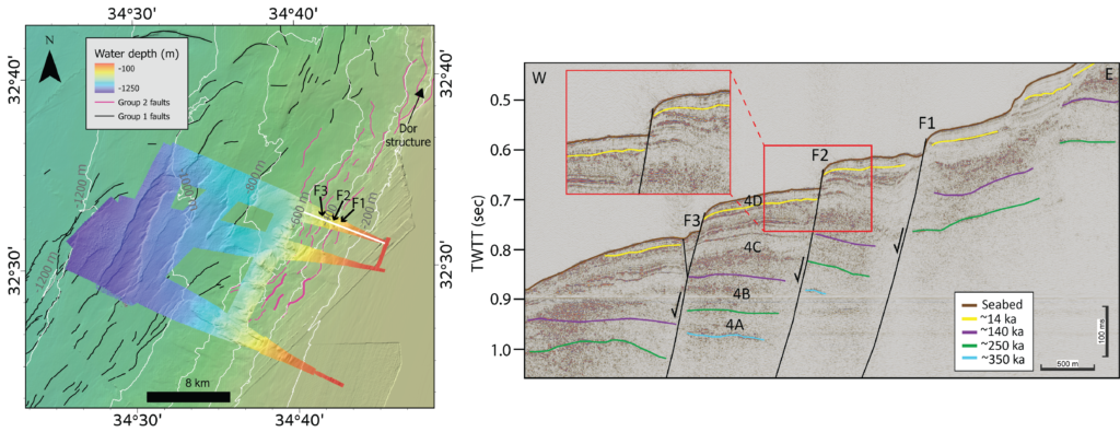
In our recent study published in Natural Hazards and Earth System Sciences, we investigated thin-skinned normal faults offshore Israel (Fig. 1). This area serves as a critical infrastructure corridor delivering offshore natural gas to onshore power stations.
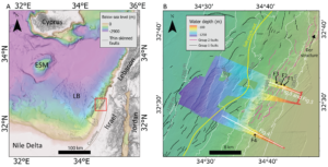
Figure 1: (A) Regional bathymetric map (from Hall, 1994 and Gvirtzman et al. 2015). The study area (shown in B) is marked in a red polygon. (B) Location map of the study area offshore northern Israel, showing mapped fault systems crossing key infrastructure zones. High-resolution (20×20 m) colored bathymetric map derived from data collected for this study along the seismic survey track.
When evaluating these faults using conventional, deep-penetrating seismic surveys, measuring the displacement across a mid-Pleistocene sediment layer (roughly 350,000 years old) yielded a modest average vertical slip rate of about 0.25 millimeters per year [6]. At that calculated pace, the faults appeared to move slowly and steadily.
To test whether this long-term average masked recent accelerations, we calculated fault slip rates at higher stratigraphic resolution than previously analyzed in this region by utilizing ultra-high-resolution seismic reflection data. This detailed imaging revealed a much younger geological boundary from approximately 14,000 years ago, marking the end of the Last Glacial Maximum.
The result was a major surprise: across this younger horizon, the calculated vertical slip rate surged to 2.4 millimeters per year, a nearly tenfold increase compared to the long-term average (Fig. 2).
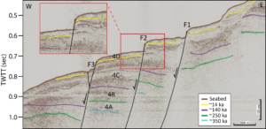
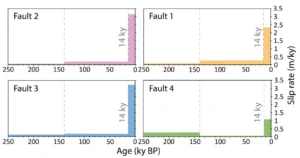
Figure 2: Upper panel: High-resolution seismic reflection cross-section showing active normal faults (F1–F3; location in Fig. 1) offsetting stratigraphic horizons dated between ~350,000 and ~14,000 years ago. The inset highlights the sharp seabed scarp and shallow displacement along fault F2. Lower panel: Calculated vertical slip rates for faults F1–F4 across the evaluated time intervals, illustrating a consistent tenfold acceleration in fault activity during the last 14,000 years following the Last Glacial Maximum.
This rapid slip solves a persistent seafloor mystery: exposed fault scarps towering up to 30 meters high in open water (Fig. 2). In an area where continuous sediment accumulation would normally bury and smooth out slow-moving faults over thousands of years, the persistence of these sharp, steep cliffs confirms that fault activity accelerated dramatically in recent geological history.
Why did these faults suddenly speed up after the LGM?
Reconstructing the displacement history across multiple intermediate sediment layers revealed that episodes of increased faulting directly coincided with periods of rapid sea-level rise (Fig. 3). During the transition from the peak of the Last Glacial Maximum into our current warm climate, global sea level rose rapidly by approximately 120 meters.
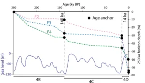
Figure 3: Correlation between displacement histories of F2, F3, and F4 faults (pink, light blue, and green dashed lines) and sea level change (the lower undulating blue line). Sea level curve modified after Waelbroeck et al. (2002). Fault activity increases during periods of sea level change.
This massive environmental shift altered the mechanical forces acting on the seafloor. As rising seawater and post-glacial sediment loaded the continental margin, the weight imposed significant stresses on the underlying strata [7,1]. In low-permeability, fine-grained marine muds, trapped fluids cannot escape rapidly under loading. This causes pore-water pressure along the fault plane to spike [e.g., 2,3]. The elevated fluid pressure counteracts normal confining stress, effectively reducing friction and allowing the fault to slip much more easily.
What Does This Means for Offshore Engineering?
These findings demonstrate that calculating fault motion based solely on ancient, deeply buried markers can significantly underestimate the actual displacement hazard faced by modern subsea installations. Understanding that environmental shifts, such as sea-level rise, can accelerate submarine shallow faults provides critical insights for designing resilient subsea energy grids, communications, and offshore structures worldwide.
To learn more, read the full open-access study in Natural Hazards and Earth System Sciences: https://doi.org/10.5194/nhess-26-4053-2026
References
[1] Brothers, D. S., Luttrell, K. M., and Chaytor, J. D.: Sea-level–induced seismicity and submarine landslide occurrence, Geology, 41, 979–982, 2013.
[2] Dugan, B. and Flemings, P. B.: Overpressure and fluid flow in the New Jersey continental slope: Implications for slope failure and cold seeps, Science, 289, 288–291, 2000.
[3] Flemings, P. B., Liu, X., and Winters, W. J.: Critical pressure and multiphase flow in Blake Ridge gas hydrates, Geology, 31, 1057–1060, 2003.
[4] Gvirtzman, Z., Reshef, M., Buch-Leviatan, O., Groves-Gidney, G., Karcz, Z., Makovsky, Y., and Ben-Avraham, Z.: Bathymetry of the Levant basin: interaction of salt-tectonics and surficial mass movements, Mar. Geol., 360, 25–39, https://doi.org/10.1016/J.MARGEO.2014.12.001, 2015.
[5] Hall, J. K.: Digital shaded-relief map of Israel and environs, Agaf. ha-medidot., 1994.
[6] Laor, M. and Gvirtzman, Z.: Classifying marine faults for hazard assessment offshore Israel: a new approach based on fault size and vertical displacement, Nat. Hazards Earth Syst. Sci., 23, 139–158, https://doi.org/10.5194/nhess-23-139-2023, 2023.
[7] Luttrell, K. and Sandwell, D.: Ocean loading effects on stress at near shore plate boundary fault systems, J. Geophys. Res.-Sol. Ea., 115, https://doi.org/10.1029/2009JB006541, 2010.
[8] Waelbroeck, C., Labeyrie, L., Michel, E., Duplessy, J. C., McManus, J. F., Lambeck, K., Balbon, E., and Labracherie, M.: Sea-level and deep water temperature changes derived from benthic foraminifera isotopic records, Quaternary Sci. Rev., 21, 295–305, https://doi.org/10.1016/S0277-3791(01)00101-9, 2002.
Edited by: Navakanesh M Batmanathan & Harriet Thompson
Coordinated and published by: Hedieh Soltanpour