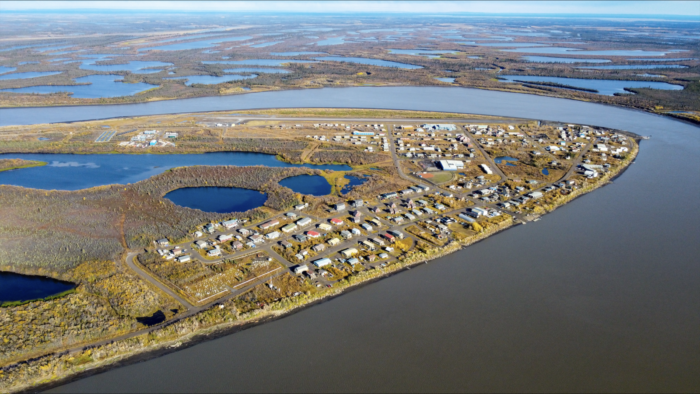
The “UndercoverEisAgenten” project takes us on a drone journey over the ever-changing permafrost landscapes. Initiated by the Alfred Wegener Institute (AWI) for Polar and Marine Research, the German Aerospace Center’s (DLR) Institute of Data Science, and the Heidelberg Institute for Geoinformation Technology (HeiGIT), this venture is about more than just capturing images. It’s about collaboration. The students at Moose Kerr School in Aklavik, Northwest Territories (Fig. 1), Canada, play a pivotal role, steering the drones and collecting invaluable data. Meanwhile, across the ocean in Germany, a unique mapping application helps analyze this data and serves as an innovative educational tool.
UndercoverEisAgenten – What’s up with the name?
The Arctic is undergoing profound landscape transformations owing to the thawing of permafrost, triggered by an air temperature rise of, meanwhile four times the global average. This thawing not only challenges the indigenous communities’ existence but also increases greenhouse gas emissions. Small-scale changes on the land’s surface from permafrost thawing are important processes but they have not been well-documented, so there is a pressing need to record and understand them better.
The heart of our project is to monitor changing permafrost landscapes in the Canadian Arctic. However, we are testing an unconventional approach of permafrost observations. Instead of relying solely on high-end equipment, we harness the power of low-cost, consumer-grade drones. These drones, combined with the wisdom and knowledge of the local communities, offer a fresh perspective on this vulnerable terrain. Additionally, our project is deeply committed to understanding the challenges and questions faced by the local community. By engaging with various members of the community, from discussing areas of noticeable change to listening to their unique stories, we capture insights that might otherwise be missed by visiting scientists alone. It is through these personal exchanges that we aim to support and address concerns that are genuinely rooted in the community’s experiences (Fig. 2).
“UndercoverEisAgenten” is a name that encapsulates our project’s goals and methods in a unique blend of words.
- Undercover: Since our drones only capture the surface, the real detective work is in spotting permafrost structures – distinct polygonal patterns on the ground (Fig. 3). By studying these permafrost polygons, we gain insights into deeper, hidden changes in the permafrost, allowing us to understand and model even the most profound layers.
- Eis: This German word for “ice” forms a bridge between the icy landscapes of Canada and our German collaborative efforts.
- Agenten: This means “agents” in German and signifies the dedicated students and citizens from both Canada and Germany. In Canada, they are on-ground observers, capturing data with drones and sharing local knowledge. In Germany, they are data analysts, diving deep into the datasets with our mapping application.
Together, “UndercoverEisAgenten” represents a union of keen observation, international collaboration, and deep analysis, all aimed at understanding the complexity of permafrost (Fig. 2).
The UndercoverEisAgenten project is funded by the German Federal Ministry of Education and Research as part of the Citizen Science funding program. It is one of 15 projects that advances the cooperation between citizens and scientists in terms of content and methodology as well as provide answers to society’s challenges until the end of 2024. Further information can be found here and here.
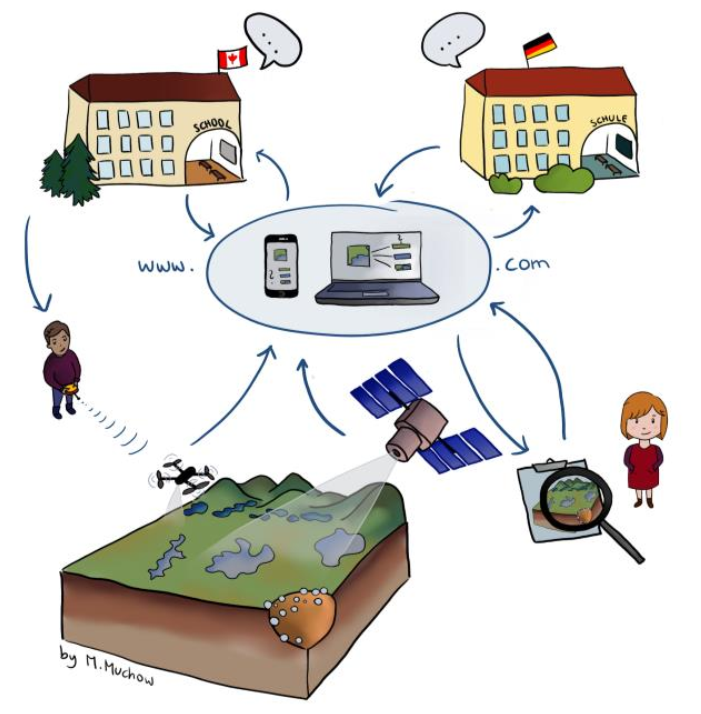
Figure 2: UndercoverEisAgenten: A transcontinental collaboration – From drone steering by indigenous Canadian school students (left) in Canada’s most western permafrost region (bottom left) in cooperation with Moose Kerr School (top left) to image analysis by school kids (right) in all over Germany with different partner schools (top right) through an online mapping application developed in the project (center). [Credit: Marek Muchow]
First visit to Aklavik in 2022
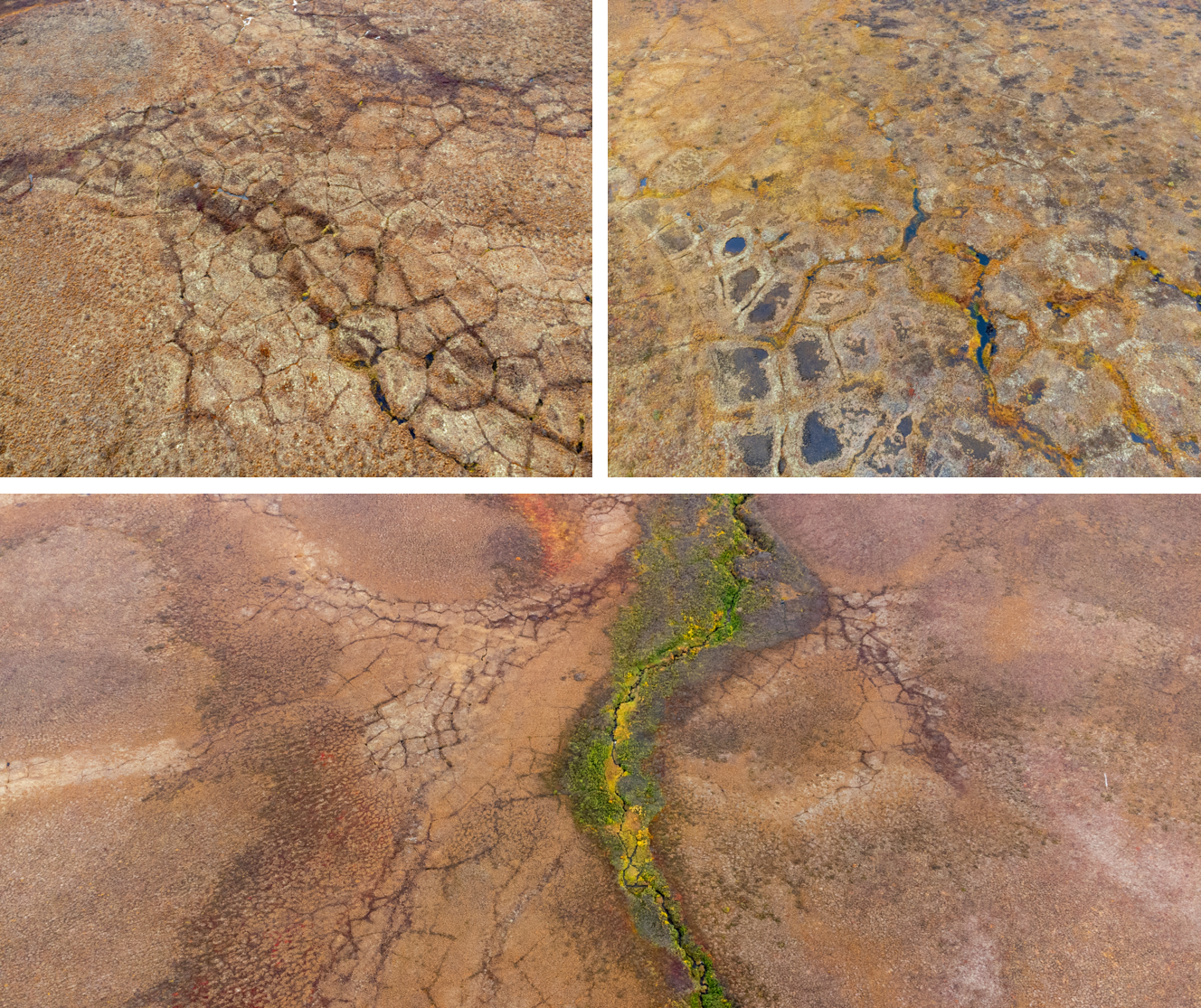
Figure 3: Ice wedge wonders: Aerial glimpses of the Arctic tundra’s diverse permafrost mosaic around “Blueberry Hill” (bottom), showcasing the different degradation stages visible through high-center (top left) and low-center (top right) permafrost polygons. [Credit: Marlin M. Mueller]
Though confronted by occasional rain showers, our determination never wavered. We traversed the landscapes of Aklavik, refined local mapping resources, and rigorously tested our drones in preparation for their student-operated adventures. Our exploration of a tundra site locally called “Blueberry Hill” (Fig. 3) served as a precursor to the subsequent student-led missions, revealing a terrain vibrant with vegetation and marked by nested permafrost polygons as well as some tasty treats as the name already suggests.
Our inaugural meeting with the Moose Kerr School students signaled the commencement of intensive drone sessions, enriched with permafrost discussions and complemented by a memorable cranberry-picking afternoon, as showcased in Fig. 4. Our investigative pursuits spanned from the softball fields to the sandy shores of the West Channel of the Mackenzie River, with drones gracefully capturing the diverse terrains around Aklavik. Each day in Aklavik was a source of newfound knowledge, from mastering drone operations to grasping the profound implications of climate change on the local environment. Over five days were spent together either flying drones in Aklavik itself or out on the land in the Arctic tundra, capturing square kilometers of polygon-rich landscapes.
The spirit of community was ever-present in our interactions, be it in sharing meals with the boat operators or engaging in enlightening dialogues on educational systems across borders. Even when unfavorable weather conditions confined us indoors, we turned to insightful sessions on “Structure from Motion” and “Crowdmapping” ensuring continuous learning for the students. As our expedition in Aklavik reached its conclusion, we were graced with a heartfelt farewell from the school community. We departed, enriched by enduring relationships, an archive of over 30,000 images, and unwavered enthusiasm for the forthcoming chapters in our journey.
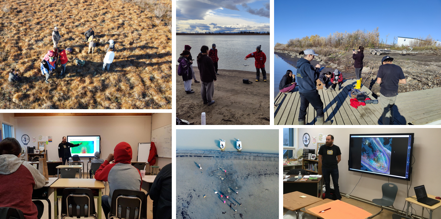
Figure 4: Integrating local insights with technological exploration: Moose Kerr School students participate in Aklavik’s UndercoverEisAgenten project. Field campaigns were conducted on tundra landscape (top left) and around Aklavik (top right). Theoretical training was provided in the classroom (bottom left and right) as well as some first practice runs with the drones on the river banks (top and bottom center). [Credit: Soraya Kaiser and Marlin M. Mueller]
Mapathons: A deep dive into permafrost mapping
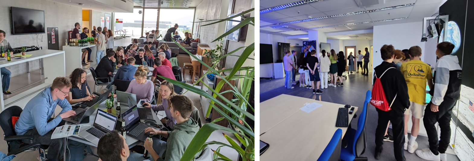
Figure 5: Diving into permafrost exploration: Snapshots from the UndercoverEisAgenten mapathons across German cities. A university mapathon in Heidelberg with some snacks drew a nice crowd of excited mappers (left) and a school project week in Jena teaching about the application of drones in practice as well as some hands-on experiments in a DLR SchoolLab. [Credit: Sabrina Marx and Marlin M. Mueller]
Permafrost, while integral to our global climate, remains largely hidden beneath the Arctic surface. To better comprehend this element of the cryosphere, the UndercoverEisAgenten project launched a crowdmapping application in May 2023 which initiated Mapathons across various cities, offering a new avenue for permafrost exploration. In venues across Heidelberg, Potsdam and Jena (in Germany), and even in Amsterdam (in the Netherlands), students gathered from universities and high schools. Their primary task was to interpret datasets from the Canadian Arctic, aiming to map, classify and derive insights from this data.
At a notable event in Heidelberg hosted by HeiGIT, participants were presented with specific tasks. These ranged from identifying permafrost polygons in drone images to contrasting this imagery with machine-learning derived layers. Certain tasks involved tracing these polygon outlines or pinpointing their central locations. Across different Mapathon events, with two of them visualized in Fig. 5 in Heidelberg and Jena, almost 28,000 answers were provided from 83 accounts within 25 hours of collaborative mapping. Point digitization emerged as particularly effective method, as users marked close to 5,000 points, proving both efficient and accurate.
The Mapathons were also a platform for academic discourse. For instance, Moritz Langer from the Vrije Universiteit Amsterdam and AWI delivered a lecture on thawing permafrost, broadening participants’ perspectives in Heidelberg. It is worth noting that the approach of Mapathons differs from the typical school project weeks we organized. The former focuses on practical application and specific tasks, while the latter emphasizes the broader implications of permafrost change, such as its global significance, carbon storage capabilities, and relevance to biodiversity and climate change. In sum, the Mapathons served as an informative and collaborative tool to delve into the world of permafrost, engaging participants in tangible climate change research.
Follow-up visit to Aklavik 2023… Mission impossible
2023 emerged as a stark reminder of climate change’s immediate effects, with Canada engulfed in historic wildfires – a calamity further stirring the already troubled Arctic landscapes we aimed to study. The fires grew vehement by June, sparing no province. The Northwest Territories witnessed an alarming burned forest area of 41,600 km². To grasp this magnitude, it is noteworthy that Germany’s entire existing forest expanse is just under 114,000 km².
Our UndercoverEisAgenten mission was to scrutinize the changing Arctic, for which datasets that span different times are very important. However, the fires, a testament to climate change’s accelerating pace, urged a reevaluation. The fires, aside from their inherent immediate destruction, were climate change catalysts, releasing greenhouse gasses that, in turn, further warmed the region – a dangerous and scary cycle indeed. Even worse on the long run: forests, plants and peat, the protective cover on the permafrost, were removed, accelerating long-term thaw and subsidence.
The local authorities’ distress signals were clear; travel to and within the Northwest Territories was discouraged. Local news and community updates on social media mirrored this sentiment, painting a picture of a territory in a battle with nature as well as the fallout of many displaced community members and relatives. We, rooted in a philosophy of community respect and safety, of course followed the advice given by the local communities. Our visit was postponed with a heavy heart, but a decision underlined by responsibility and adaptability.
Though unforeseen, the wildfires illuminated an indirect yet clear connection to our project. The ferocity and persistence of these fires until mid-September underscored the crucial need for monitoring such landscapes. Our modest drones, tools for permafrost study today, could morph into chances for wildfire tracking tomorrow.
We have plans to return to Aklavik in the near future. Initially, a brief visit in early spring 2024 is planned to share the processed data and discuss what has been achieved so far with the community as well as plan ahead for the year. Later, in September 2024, a more extensive visit is anticipated to repeat drone missions in the fall season, resume and explore the changes of the landscape together and share our lessons learned.
We cannot wait to reunite with the students and other community members we have met and are eager to continue the collaborative research. With hopes for calmer conditions next summer, the journey of joint exploration and learning will continue in the coming year. After all, we have great hopes to continue our work in the region on the topic of permafrost change with our new friends and young citizen scientists, also after the project ends in December 2024.
Further reading
- An article about the development of “ScIQ”, a framework for melding scientific and traditional Inuit knowledge to foster community engagement: Pedersen et al. (2020) ScIQ: an invitation and recommendations to combine science and Inuit Qaujimajatuqangit for meaningful engagement of Inuit communities in research. Arctic Science.
- An article exploring the utility of UAV imagery in monitoring permafrost degradation using cost-effective hardware: Kaiser et al. (2022) The Potential of UAV Imagery for the Detection of Rapid Permafrost Degradation: Assessing the Impacts on Critical Arctic Infrastructure. Remote Sensing.
- An article presenting the newly developed flight designs for the use with consumer-grade drones in this project: Mueller et al. (2023) Novel UAV Flight Designs for Accuracy Optimization of Structure from Motion Data Products. Remote Sensing.
- An article on engaging public audiences by citizen science. Wagenknecht et al. (2021) A question of dialogue? Reflections on how citizen science can enhance communication between science and society. Journal of Science Communication 20(03).
- A comprehensive collection of information about the NWT wildfires: CabinRadio Wildfires
- An EGU Cryosphere Blog on the role of microbes in thawing permafrost by Maria Scheel: It’s getting hot in here: Ancient microbes in thawing permafrost
- An EGU Cryosphere Blog on the role of grazers on permafrost and soil carbon by Torben Windirsch: Small step for reindeer – large leap for humankind?
- A comprehensive and recently released resource on permafrost: The Permafrost Atlas
Edited by David Docquier and Lina Madaj
 Marlin M. Mueller is a researcher specializing in the field of remote sensing and satellite imagery. Based at the German Aerospace Center in Jena his studies focused on the utilization of Sentinel-1 time series as well as high-resolution UAV data to understand forest ecosystems and evapotranspiration dynamics. Recently, as a part of his PhD within the UndercoverEisAgenten project, he has been concentrating on optimizing low-cost UAV applications for use in a crowdsourcing context. He tweets as @marlinmmmm. Contact Email: Marlin.Mueller@dlr.de
 Josefine Lenz is a permafrost researcher with a great interest in connecting research and society. As a science communication coordinator at the Alfred Wegener Institute (AWI) in Potsdam, Germany, and project manager of the UndercoverEisAgenten, she works with schools, teachers and other public audiences to make permafrost research visible and accessible – and even better: Getting kids on board for permafrost science! She tweets as @_JosefineLenz. Contact: Josefine.Lenz@awi.de
![Image of the Week – On thin [Arctic sea] ice](https://blogs.egu.eu/divisions/cr/files/2018/10/kayak-161x141.jpg)