Would you like to join me on a little trip up North today? We will be visiting a small community in the Canadian high Arctic – a community built on permafrost ground. This sounds pretty cool in the first place, but brings along quite a few challenges that most of us probably do not have to think about. Let me introduce you to Tuktoyaktuk, the community that is endangered to fall into the sea…
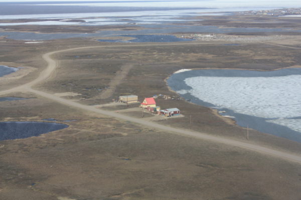
Let’s take a step back and look at these three houses in the picture above (Fig. 1). Is there anything that comes to mind when looking at them? Yes, they look a bit lonely there, but otherwise they do not differ much from any other houses, do they? They do not. What makes these houses different from most other houses is that they have not been built where they are standing right now; they have been moved from their original location – hence the “loneliness”. Why have they been moved you might wonder, was it not a good location? They were actually standing in a very nice location: directly at the coast and in the center of the community of Tuktoyaktuk with a beautiful view on the Arctic Ocean. In 2020, the inhabitants of these houses had to give up on this view and move their houses to prevent them from falling into the Arctic Ocean.
Arctic coastal erosion
To understand the hazards Tuktoyaktuk is facing, we have to zoom out a bit and look at where the community is actually located. Tuktoyaktuk is a small community of around 900 people, the majority of them Inuvialuit indigenous people, directly located at the Arctic Ocean in the Northwest Territories in Canada. The community is entirely situated on Inuvialuit Private Lands, the lands of the Inuvialuit people who have been living and hunting on these lands for about 1000 years. These lands are located on continuous permafrost (Fig. 2), ground that has been frozen for at least two consecutive years and in this location with a coverage of over 90% (= continuous, in comparison to discontinuous and sporadic permafrost, see Fig. 2).
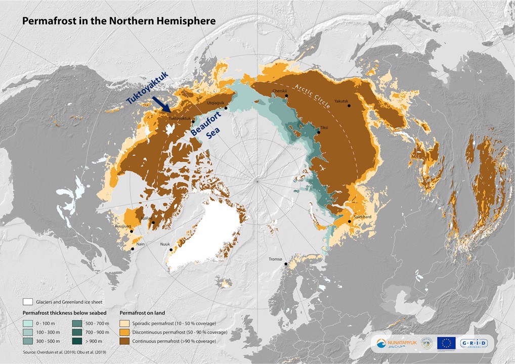
Figure 2: Map of Northern Hemisphere permafrost distribution with the locations of Tuktoyaktuk, indicated by dark blue arrow, and the Beaufort Sea. [Credits: Grid Arendal & Nunataryuk, 2020]
The exceptional importance of Tuktoyaktuk Harbour
Here is another exceptional fact about Tuktoyaktuk: its harbour is the only deep-water port along the Arctic Ocean that is connected to the rest of North America. That is because since 2017, Tuktoyaktuk is connected to Inuvik, a town further south in the Canadian Arctic, via the Inuvik-Tuktoyaktuk Highway, to the road system of North America. This road is accessible all year long, which is not usually the case for smaller Arctic communities; they are normally only reached by boat in summer or by snowmobile over an ice-road in winter. This unique situation increases the national importance of the harbour with regards to marine transportation, on top of its significant importance for the local community for transport, subsistence fishing and Arctic sovereignty. However, even though the harbour has water depths up to 20 m and above, it has two comparably shallow entrances. The increased coastal erosion does not only endanger the coastline and therefore the infrastructure of the town, but it is also discharging large amounts of sediments into the coastal ocean. These sediments reach the harbour via transport through coastal ocean currents and make the harbour entrances even shallower when they sink to the seafloor, which in turn can have significant influence on shipping, fishing and marine wildlife.
The barrier island, Tuktoyaktuk Island, that is currently sheltering the harbour and the community along the harbour from waves and larger amounts of sediments entering the harbour, is expected to breach within the next 20 years, if erosion rates stay this high or increase even more (Whalen et al., 2022). This would have dramatic consequences for the whole community, including higher risks of flooding.

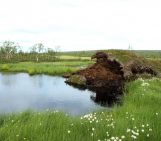
Figure 3: Visible coastal erosion in Tuktoyaktuk (left) and along Pelly Island (right), one of the barrier islands outside the Mackenzie River Delta, Beaufort Sea Coast, August 2022 [Credits: Lina Madaj]
Future of Tuktoyaktuk
Despite extensive research and a variety of coastal protection measurements already in place, coastal erosion remains the biggest threat to this community. Members of the community are closely monitoring the coastal erosion within their own climate resilience project to better understand the changes happening to their land and to create a base for future decisions with regards to ensuring the towns existence. Sadly, the three houses that have been moved so far are not an exception and currently, the community is facing the reality of a possible relocation.
Sometimes, the threats caused by increasing air temperatures and sea level seem far away for us, a challenge we have to face in the future and now only wonder how it might be with still time to prepare. For Tuktoyaktuk, however, and many other places around the globe, they are already a crucial reality.
Further Reading
- Find out about current research and coastal erosion adaption measures in Tuktoyaktuk: https://futuretuktoyaktuk.org/
- Latest publication about coastal erosion along Tuktoyaktuk Island by Dustin Whalen et al. (Natural Resources Canada)
- Find out about the challenges other Arctic communities are facing due to rapidly thawing permafrost with this interactive story map of studies from three communities in Canada, Greenland and Svalbard
Previous blog posts about risks from thawing permafrost:
- You left us too early: a eulogy to permafrost by Loeka Jongejans
- It’s getting hot in here: Ancient microbes in thawing permafrost by Maria Scheel
- For Dummies – How do wildfires impact permafrost? [OR.. a story of ice and fire] by Jean Holloway
- Image of the Week – When the dirty cryosphere destabilizes! by Laura Helene Rasmussen
Edited by Loeka Jongejans
 Lina Madaj is a postdoctoral researcher at the Vrije Universiteit Amsterdam in the Netherlands. Her research focusses on coastal erosion along the Canadian Beaufort Sea Coast and the fate of organic carbon discharge into the ocean through thawing permafrost. For her field work she spent a few weeks in Tuktoyaktuk. A side project of hers is investigating the impacts of increased sediment input into Tuktoyaktuk Harbour. She tweets as @Oktopus_76N
Contact email: l.madaj@vu.nl

terapan
Why were some houses in Tuktoyaktuk moved from their original location?
Regard : S2 Akuntansi