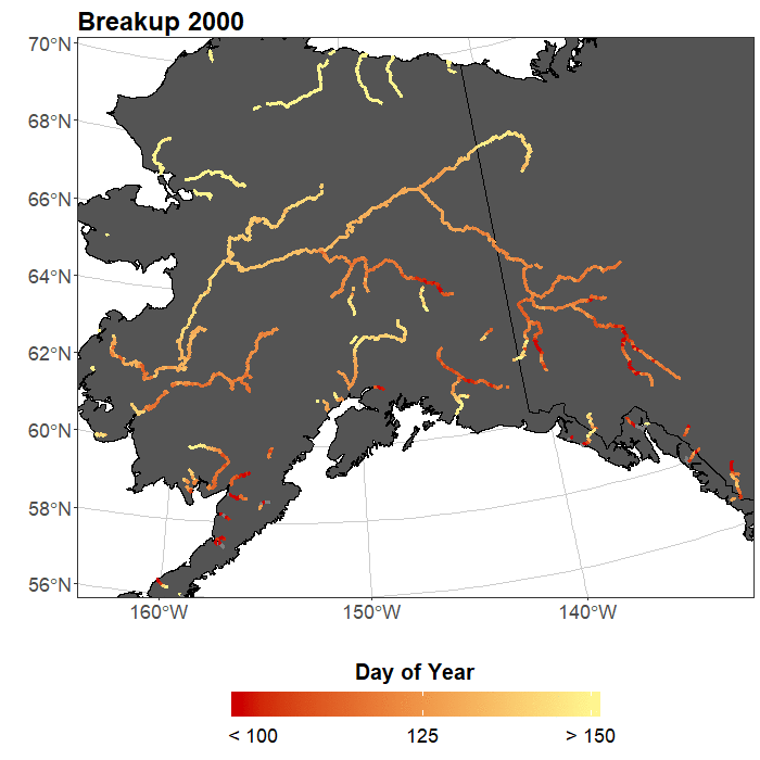
Figure 1. Dates of ice breakup on Alaskan river reaches wider than 150 m calculated using Moderate Resolution Imaging Spectroradiometer (MODIS) data. [Credit: Wayana Dolan].
Common images associated with climate change include sad baby polar bears, a small Arctic sea ice extent, retreating glaciers, and increasing severe weather. Though slightly less well-known, river ice is a hydrological system which is directly influenced by air temperature and the amount and type of precipitation, both of which are changing under a warming climate. Ice impacts approximately 60 % of rivers in the Northern Hemisphere and therefore will be a clear indicator of climate change over the coming century.
River ice terminology
First, I think it is important to get some quick vocabulary out of the way. There are three primary variables used to study large-scale trends in river ice:
- Ice freeze-up: The process of ice accumulation on a river reach (a segment of a river), usually during the autumn or winter.
- Ice breakup: The process of ice loss from a river segment. Breakup style is often related to a pulse of increased runoff from snow melt, known as the spring flood wave. Thermal breakup occurs when river ice melts prior to the arrival of the spring flood wave. It is a slow and relatively calm process. Alternatively, mechanical breakup occurs when ice on a river has not melted prior to the arrival of the spring flood wave. Mechanical breakups often cause severe ice jam floods, whereas thermal breakups are rarely associated with flooding events. You can observe an example of mechanical ice breakup and associated ice jam flooding in 2018 on the North Saskatchewan River at Petrofka Orchard on the video below [Credit: Planet Labs, Inc.].
- Ice cover duration: The length of time a river segment is ice-covered between freeze-up and breakup.
Now that we know these key phrases, let’s get to the good stuff!
Why should you care about river ice?
Shifts in river ice cover duration can be used as an indicator for Arctic climate change due to its relationship with air temperature and precipitation (Prowse et al. 2002). Hotter air temperatures generally relate to earlier ice breakup, later ice freeze-up, and shorter ice cover duration. These trends in breakup and freeze-up have been observed over the past 150 years on multiple rivers in the Northern Hemisphere by Magnuson et al. 2000. Many arctic communities rely on ice roads, which often travel across frozen rivers, lakes, and wetlands. These roads are important for transporting food, fuel, and mining equipment, to predominately first nations people. They are also commonly used by people who live subsistence-based lifestyles for hunting and trapping during the winter months. If ice cover duration shortens, these roads will be stable for a shorter period each winter. Alternatively, longer ice-free seasons would allow for decreased shipping costs in many boreal and Arctic regions, which currently use ice breaking to clear shipping pathways (Prowse et al. 2011). Another trend observed in several large Arctic rivers is a shift from mechanical breakup to thermal breakup (Cooley & Pavelsky, 2016). While this change could lead to a decrease in ice jam flood damage to hydropower and other infrastructure, it could also cause a dramatic decrease in sediment and nutrient transport to near-river Arctic ecosystems such as floodplains and deltas.
Recent research has shown ice cover trends to be geographically complex and dependent upon variables such as air temperature, basin size, and precipitation (Bennett & Prowse, 2010; Prowse et al. 2002; Rokaya et al. 2018). However, many of these trends are poorly understood on a pan-Arctic scale.
How do we measure changes in river ice?
From the early-1980s through the mid-2000s, satellites missions such as Landsat and the Moderate Resolution Imaging Spectroradiometer (MODIS) began allowing researchers to study ice on rivers in inaccessible areas. However, computing power limited the size and scale of rivers which could be observed. More recently, data processing through platforms like Google Earth Engine allow river ice to be studied on a much larger scale.
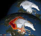
The University of North Carolina at Chapel Hill (UNC) has a working group which makes use of these new programs to study changes in pan-Arctic river and lake ice. My current project seeks to quantify historical river ice breakup and freeze-up using MODIS. We have developed an ice detection algorithm that has successfully been applied to all river reaches in Alaska wider than 150 m, limited by the 250 m spatial resolution of MODIS (Figure 1). Note that our detection algorithm can be applied to rivers which are slightly sub-pixel in width. I am currently working on calculating trends in this dataset and the expansion of the algorithm to pan-Arctic rivers, so that we can better identify which regions in the Arctic are changing the fastest. A quick glance at the dataset reveals that ice breakup is highly variable through time and space, even between upstream and downstream reaches of the same river. Internal variation in breakup dates within a given river may be caused by temperature gradients along the river profile, changes in elevation, as well as variation in the amount and type of precipitation. Additionally, preliminary work by UNC postdoctoral researcher Xiao Yang uses Google Earth Engine, Landsat, and MERRA-2 data to globally model river ice (Figure 2). This model can be applied to future climate change scenarios to see how river ice will change as the temperature warms. Keep an eye out for this paper in the next few months!
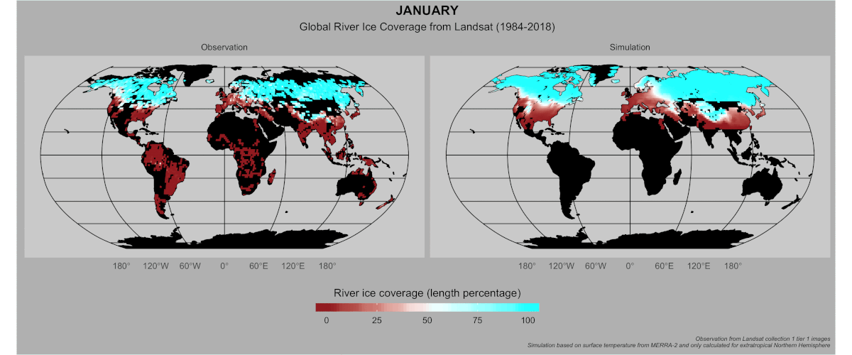
Figure 2. Preliminary results from modelling global river ice coverage using Landsat imagery, latitude, longitude, and surface air temperatures from MERRA-2. Colors refer to the percentage of the total river length in each area that is ice-covered each month (aggregated from 1984 to 2018) [Credit: Xiao Yang].
Future outlook
River ice cover duration is expected to shorten as the climate warms. Shifts in ice breakup and freeze-up processes can impact sediment and nutrient delivery, Arctic transportation and hunting, and ice-related hazards. However, our preliminary results show that river ice breakup varies both spatially and temporally throughout Alaska (Figure 1). Ongoing research at UNC will allow researchers to identify areas of the pan-Arctic which are most vulnerable to river ice-related change.
Further resources
- A video of mechanical ice breakup
- Google Earth Engine has a vast archive of satellite data and it is free!
- If you are interested in working on river or lake ice on a global scale and want to collaborate, please contact the Global Hydrology Lab at the University of North Carolina Chapel Hill
- Image of the Week – Monitoring icy rivers from space!
Edited by Scott Watson
 Wayana Dolan is a current M.S. student and future Ph.D. student at the University of North Carolina at Chapel Hill (USA) working with Dr. Tamlin Pavelsky. Her current research involves using remote sensing to study large-scale changes in river ice. She is passionate about any project that allows her to do Arctic fieldwork. Dolan also works with the WinSPIRE program – a summer research internship for female high school students in North Carolina. You can contact her by email or on twitter as @wayana_dolan.
Mike Steele
Cool sorry no cold stuff Wyana! Rivers make the Arctic Ocean fresh, so I’m a fan. Happy Thanksgiving weekend! -Mike Steele