The Greenland ice sheet flows from the interior out to the margins, forming fast flowing, channelized rivers of ice that end in fjords along the coast. Glaciologists call these “outlet glaciers” and a large portion of the mass loss from the Greenland ice sheet is occurring because of changes to these glaciers. The end of the glacier that sits in the fjord is exposed to warm ocean water that can melt away at its face (a.k.a. its “terminus”) and force the glacier to retreat. As the glaciers retreat, they thin and this thinning can spread into the interior of the ice sheet along the glacier’s flow, causing glaciers to lose ice mass to the ocean as is shown in our Image of the Week. But how far inland can this thinning go?
Not all glaciers behave alike
NASA’s GRACE mission measures mass changes of the Earth and has been used to measure ice mass loss from the Greenland ice sheet (see Fig. 1a). The GRACE mission has been extremely valuable in showing us where the largest changes are occurring: around the edge of the ice sheet. To get a closer look, my colleagues and I use a technique called photogrammetry.
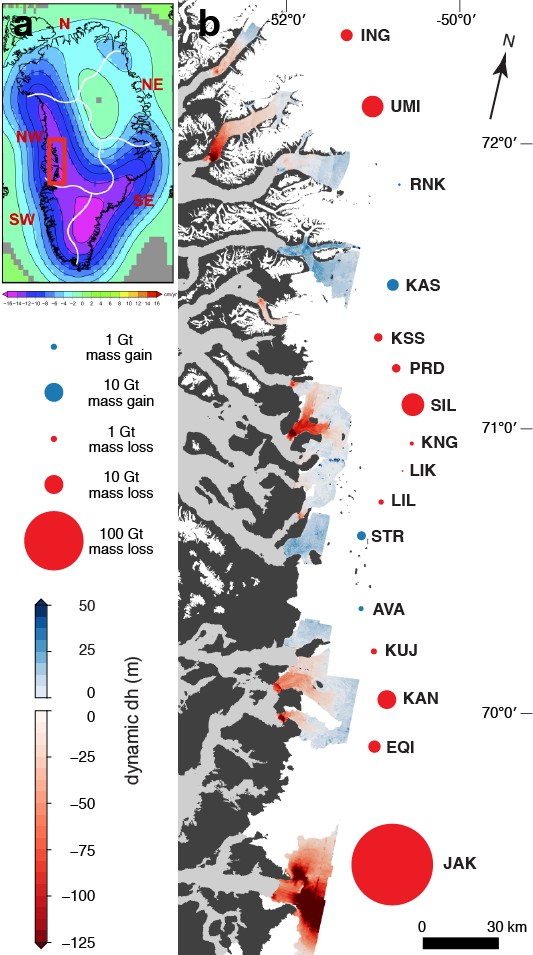
Using high-resolution satellite photos, we created digital elevation models of the present-day outlet glacier surfaces. The imagery was collected by the WorldView satellites and has a resolution of 50 cm per pixel! When we compared our present-day glacier surfaces with surfaces from 1985, with the help of an aerial photo survey of the ice sheet margin (Korsgaard et al., 2016), we found that glacier thinning was not very uniform in the West Greenland region (see our Image of the Week, Fig. 1b). Some glaciers thinned by over 150 meters at their termini but others remained stable and may have even thickened slightly! Another observation is that, of the glaciers that have thinned, some have thinned only 10 kilometers into the interior while others have thinned hundreds of kilometers inland (Felikson et al., 2017).
But atmospheric and ocean temperatures are changing on much larger scales – they can’t be the cause of these huge differences in thinning that we observe between glaciers. So what could be the cause of the differences in glacier behaviour? My colleagues and I used kinematic wave theory to help explain how each glacier’s unique shape (thickness and steepness) can control how far inland thinning can spread…
A kinematic wave of thinning
As a glacier’s terminus retreats, it thins and this thinning can spread upglacier, into the interior of the ice sheet, along the glacier’s flow. This spreading of thinning can be modeled as a diffusive kinematic wave (Nye, 1960). This means that the wave of thinning will diffuse in the upglacier direction while the flow of ice advects the thinning in the downglacier direction. An analogy for this process is the spreading of dye in a flowing stream. The dye will spread away from the source (diffusion) and it will also be transported downstream (advection) with the flow of water.
The relative rates of diffusion and advection are given by a non-dimensional value called the Peclet number. For glacier flow, the Peclet number is a function of the thickness of the ice and the surface slope of the ice. Where the ice is thick and flat, the Peclet number is low, and thinning will diffuse upglacier faster than it advects downglacier. Where the ice is thin and steep, the Peclet number is high, and thinning will advect downglacier faster than in diffuses upglacier.
Let’s take a look at an example, the Kangilerngata Sermia in West Greenland…
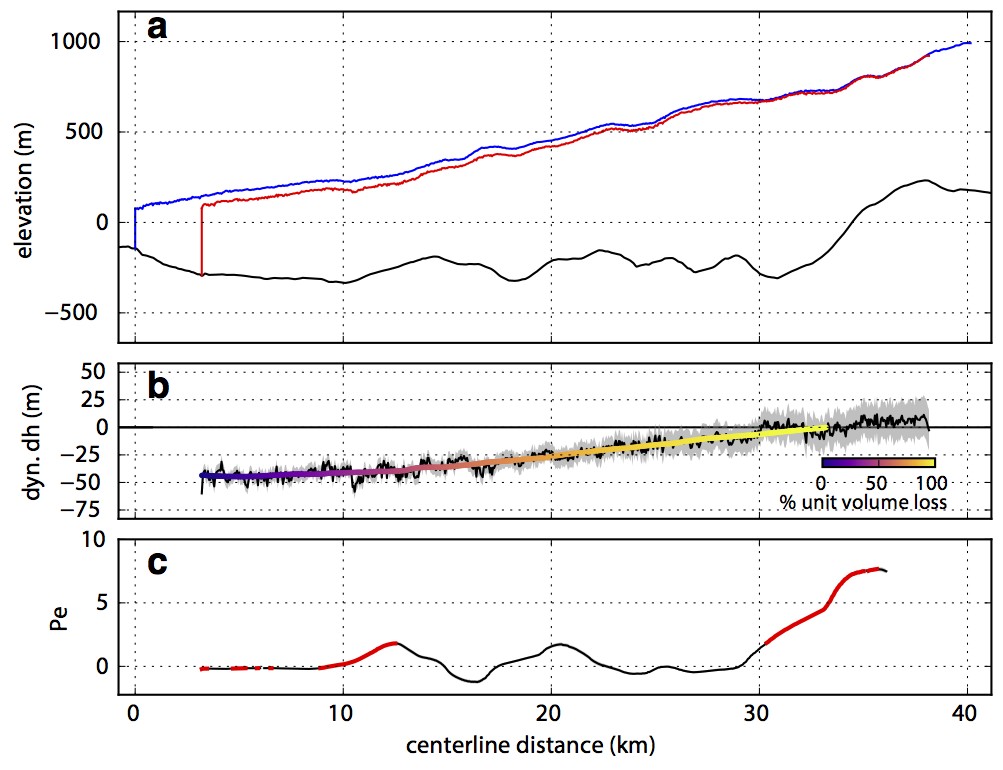
Figure 2: Thinning along the centreline of Kangilerngata Sermia in West Greenland. (a) Glacier surface profile in 1985 (blue), present-day (red), and bed (black). (b) Dynamic thinning from 1985 to present along the profile with percent unit volume loss along this profile shown as colored line. (c) Peclet number along this profile calculated from the geometry in 1985 with Peclet number running maxima highlighted (red). [Credit: Denis Felikson]
There, dynamic thinning has spread from the terminus along the lowest 33 kilometers (see Fig. 2). At that location, the glacier flows over a bump in the bed, causing the ice to be thin and steep. The Peclet number is “high” in this location, meaning that any thinning here will advect downglacier faster than it can spread upglacier. Two important values are needed to further understand the relationship between volume loss and Peclet number. On the one hand, we compute the “percent unit volume loss”, which is the cumulative thinning from the terminus to each location normalized by the total cumulative thinning, to identify where most of the volume loss is taking place. On the other hand, we identify the “Peclet number running maxima” at the locations where the Peclet number is larger than all downglacier values. These locations are critical because if thinning has spread upglacier beyond a local maximum in the Peclet number, and accessed lower Peclet values, then thinning will continue to spread until it reaches a Peclet number that is “large enough” to prevent further spreading. But just how large does the Peclet number need to be to prevent thinning from spreading further upglacier?
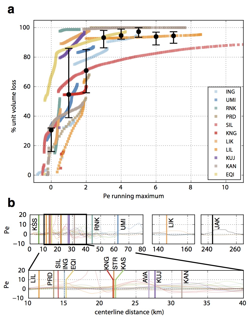
Figure 3: (a) Percent unit volume loss against Peclet number running maximum for 12 thinning glaciers in West Greenland. (b) Distances from the termini along glacier flow where the Peclet number first crosses 3. Abbreviations represent glacier names [Credit: Denis Felikson]
If we now look at the percent unit volume loss versus Peclet number running maxima for not only one but twelve thinning glaciers in the region, we see a clear pattern: as the Peclet number increases, more of the volume loss is occurring downglacier (see Fig. 3). By calculating the medians of the glacier values, we find that 94% of unit volume loss has occurred downglacier of where the Peclet number first crosses three. All glaciers follow this pattern but, because of differences in glacier geometry, this threshold may be crossed very close to the glacier terminus or very far inland. This helps explaining the differences in glacier thinning that we’ve observed along the coast of West Greenland. Also, it shows that the Peclet number can be a useful tool in predicting changes for glaciers that have not yet retreated and thinned.
Further reading
- Felikson, D., Bartholomaus, T.C., Catania, G.A., Korsgaard, N.J., Kjær, K.H., Morlighem, M., Noël, B., van den Broeke, M., Stearns, L.A., Shroyer, E.L. and Sutherland, D.A., 2017. “Inland thinning on the Greenland ice sheet controlled by outlet glacier geometry.” Nature Geoscience 10, 366-369.
- Korsgaard, N.J., Nuth, C., Khan, S.A., Kjeldsen, K.K., Bjørk, A.A., Schomacker, A. and Kjær, K.H., 2016. “Digital elevation model and orthophotographs of Greenland based on aerial photographs from 1978-1987“. Scientific data, 3.
- Nye, J. F., 1960. “The response of glaciers and ice-sheets to seasonal and climatic changes.” Proceedings of the Royal Society. Series A. 256, 559–584.
- Velicogna, I., T.C. Sutterley, and M.R. van den Broeke, 2014, “Regional acceleration in ice mass loss from Greenland and Antarctica using GRACE time-variable gravity data”, Geophys. Res. Lett., 41(22), 8130-8137, doi:
-
Edited by Clara Burgard
 Denis Felikson is a Ph.D. Candidate at the University of Texas at Austin, US. Using remote sensing and modeling, he studies the dynamics of outlet glaciers around the Greenland ice sheet to better understand how glacier dynamics affect mass change of the ice sheet. He tweets as @DenisFelikson.