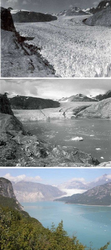
The Muir is a valley glacier (Alaska) that has significantly retreated over the last 2 centuries. The 3 pictures have the same field of view and record the changes that occurred during the 63 years separating 1941 and 2004.
In the 1941, the terminus of the glacier is on the lower right corner of the photo. The Muir is then a tidewater glacier up to 700m thick and is well connected to its tributary, the Riggs Glacier (upper right part of the photo).
9 years later, in 1950, the Muir Glacier has retreated by more than 3 km, is more than 100m thinner but is still connected to Riggs Glacier.
By 2004, the Muir glacier has retreated further inland and its terminus is no longer visible on the picture. The Riggs glacier is now disconnected to the Muir and has retreated by 0.25km. Vegetation has invaded the place.
Credits:
The photo comes from and the text is inspired from the section “Repeat photography of the Alaskan Glaciers” on U.S. Geological Survey website.
Photo 1: W. O. Field, # 41-64, courtesy of the National Snow and Ice Data Center and Glacier Bay National Park and Preserve Archive.
Photo 2 : W. O. Field, # F50-R29, courtesy of the Glacier Bay National Park and Preserve Archive.
Photo 3: B. F. Molnia, USGS Photograph

Kim Weaver
Does anyone have a current photo taken at the same location?
Pingback: 2.2 Hydrosphere/Cryosphere-Muir Alaskan Glacier. – Environmental Science-1301-Krystal Rocha
anonymous
the 1st and 3rd ohotos are not from the same location
Carol Parham
Yes it is!
anonymous
the position of the camera is not the same in all three photos. where is the camera located in picture 2 as opposed to picture 3?