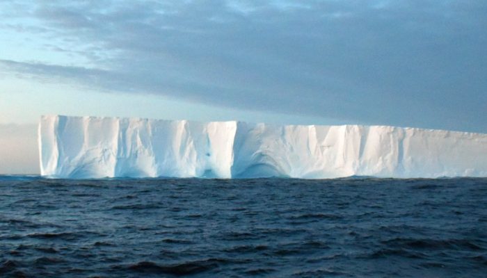
EGU Blogs

Highlights

Geology for Global Development

Demonstrating the Importance of Geoscience in the Transformation Towards Sustainable and Resilient Societies

Demonstrating the Importance of Geoscience in the Transformation Towards Sustainable and Resilient Societies

Next week the UN Annual Forum on Science, Technology and Innovation for the Sustainable Development Goals (SDGs) will discuss the science required for “transformation towards sustainable and resilient societies”. Discussions will focus on SDGs 6 (water and sanitation), 7 (energy), 11 (sustainable cities), 12 (responsible consumption and production) and 15 (life on land).   This forum will bring to ...[Read More]

CR
Cryospheric Sciences

Image of the Week – Antarctica: A decade of dynamic change

Image of the Week – Antarctica: A decade of dynamic change

   Whilst we tend to think of the ice flow in Antarctica as a very slow and steady process, the wonders of satellites have shown over the last two decades it is one of the most dynamic places on Earth! This image of the week maps this dynamical change using all the satellite tools at a scientist’s disposal with novel statistical methods to work out why the change has recently been so rapid. Why do ...[Read More]

GD
Geodynamics

Postcard from Tokyo: JpGU2018 conference

Postcard from Tokyo: JpGU2018 conference

Konichiwa from Tokyo and JpGU2018! This week, 20-24 May, the Japanese Geoscience Union (JpGU) is holding its annual union meeting just outside of Tokyo, in Chiba (about 40 minutes by metro). I am fortunate enough to be on a research visit to the Earth-Life Science Institute (ELSI) at Tokyo Tech over on the other side of the city and so attending JpGU was a bonus. It is my first time in attendance ...[Read More]

GeoLog

Top ten tourist beaches threatened by tsunamis

Top ten tourist beaches threatened by tsunamis

December 2004 saw one of the deadliest natural disasters in recorded history. 228,000 people were killed when an earthquake off the coast of the Indonesian island of Sumatra triggered tsunami waves up to 30 m high. The destruction was extreme as the waves hit 14 different countries around the Indian Ocean. Economic losses totalled over 10 billion US dollars. The tourism industry in particular suff ...[Read More]

Geochemistry, Mineralogy, Petrology & Volcanology

Fire, Fog, Frost, Famine – French Revolution? The Lakagígar eruption in Iceland, 1783-1784 [Part 2]

Fire, Fog, Frost, Famine – French Revolution? The Lakagígar eruption in Iceland, 1783-1784 [Part 2]

PART II: Were the Haze Hardships caused by Men? Famine Before the Lakagígar eruption, the population of Iceland was 48810 people; four years later, it was down to 38518. Disregarding about 1500 deaths which were caused by a smallpox epidemic, the eruption may still have killed about 1/6 of the population [5]. These deaths were not directly caused by the lava or by toxic gases. The main cause was h ...[Read More]

NH
Natural Hazards

Natural Groundwater Quality: an underestimated and yet dangerous hazard.

Natural Groundwater Quality: an underestimated and yet dangerous hazard.

Today I have the pleasure to interview Dr. Evangelos Tziritis, a brilliant scientist and a friend. He will talk to us about Natural groundwater quality hazard and its implications. This blog aim is to discuss Natural Hazards. Therefore, today we will focus on the natural component of water quality, disregarding anthropogenic sources.  Evangelos is a Research Scientist at the Soil and Water Resourc ...[Read More]

GeoLog

Imaggeo on Mondays: A volcanic point of view

Imaggeo on Mondays: A volcanic point of view

It’s not every day that you can peer into a volcano, much less gaze out at the sky from the inside of one. The Algar do Carvão, or “the Cavern of Coal,” is one of the few places on Earth where you can explore the underground reaches of a volcanic site. The volcanic pit is found on the island of Terceira, part of the Azores archipelago. This collection of islands is an autonomous region of Portugal ...[Read More]

CR
Cryospheric Sciences

Image of the Week — Biscuits in the Permafrost

Image of the Week — Biscuits in the Permafrost

In Svalbard, the snow melts to reveal a mysterious honeycomb network of irregular shapes (fig. 1). These shapes may look as though they have been created by a rogue baker with an unusual set of biscuit cutters, but they are in fact distinctive permafrost landforms known as ice-wedge polygons, and they play an important role in the global climate. Ice-wedge polygons: Nature’s biscuit-cutter In wint ...[Read More]

GD
Geodynamics

EGU 2018: Experience of a first time attendee

EGU 2018: Experience of a first time attendee

Your first time at the General Assembly can be a daunting experience. It’s not easy to navigate the scientific programme and let’s not even mention navigating the building! It becomes even more difficult if you do not know many people in your scientific community yet. Luckily, one of the easiest things to do at EGU is meeting new people. Jyotirmoy Paul, PhD student at the Indian Instit ...[Read More]