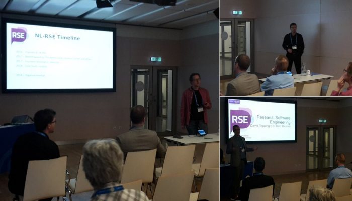
We have recently contributed to a new open access article included in a special volume coordinated by the International Association for Promoting Geoethics (IAPG). This article, synthesises the role of geoscientists in the delivery of the UN Sustainable Development Goals, the Sendai Framework for Disaster Risk Reduction, and the Paris Climate Change Agreement, and discusses ways in which we can in ...[Read More]
If you didn't find what you was looking for try searching again.
GeoLog
Malawi High School Teacher’s Workshop on Natural Hazards
In July 2017, Professor Bruce Malamud and Dr Faith Taylor from King’s College London travelled to Mzuzu, Malawi to work in collaboration with Mr James Kushe from Mzuzu University, Malawi. They delivered an EGU funded workshop at Mzuzu University to high school teachers on natural hazards, with major funding provided by EGU, and also supported by Urban ARK and Mzuzu University. Faith and Bruce expl ...[Read More]
Geodynamics
The lost Tethyan seaways: A deep-Earth and deep-time perspective on eastern Tethyan tectonics
Every 8 weeks we turn our attention to a Remarkable Region that deserves a spot in the scientific limelight. Following from the first entry which showcased the Eastern Mediterranean, we move further east, and back in time, to the realm of the Tethys. The post is by postdoctoral researcher Sabin Zahirovic of the EarthByte Group and Basin GENESIS Hub, The University of Sydney. The southern and south ...[Read More]
Geology for Global Development
Introducing Our New Authors (3) – Jesse Zondervan
We’ve been introducing you to a couple of new faces on the GfGD blog, bringing fresh ideas and perspectives on topics relating to geoscience and sustainable development. We’re delighted to have their input, and look forward to their posts. Today we interview Jesse Zondervan. I’m Jesse Zondervan, a PhD student at Plymouth freshly arrived from Imperial College in London and I hope to use the science ...[Read More]
GeoLog
Imaggeo on Mondays: Measuring the wind direction
Remote, rugged, raw and beautiful beyond measure, the island of South Georgia rises from the wild waters of the South Atlantic, 1300 km south east of the Falkland Islands. The Allardyce Range rises imposingly, south of Cumberland Bay, dominating the central part of the island. At its highest, it towers 2935 m (Mount Paget) above the surrounding landscape. In the region of 150 glaciers carve their ...[Read More]
Geology for Global Development
Wearing the Earth Down: The Environmental Cost of Fashion
Eloise Hunt is an Earth science student at Imperial College London, and coordinator of the GfGD University group there. Today we publish her first guest article for the GfGD blog, exploring the environmental cost of fashion. When we think of pollution, we imagine raw sewage pumped into rivers, open-cast mines or oil spills. We don’t often think of our inconspicuous white shirt or new jeans. But, ...[Read More]
Geochemistry, Mineralogy, Petrology & Volcanology
Ongoing unrest at Agung Volcano, Indonesia
Agung volcano, a 3.1 km high cone located in the east of Bali, Indonesia, which last erupted in 1963 killing ~1500 people (Self and Rampino, 2012), is currently undergoing seismic unrest, and steam/gas emissions have been observed at the surface. This has led the Indonesian authorities to evacuate areas around Agung which could be affected by volcanic hazards, leading to the displacement of over 7 ...[Read More]
Biogeosciences
Identification of past methane emission altering the foraminiferal tests by secondary overgrowth of calcium carbonate.
Ever heard about foraminifera? These tiny benthic (living at the seafloor) marine organisms are common in oceans across the globe and can be used to accurately give relative dates to sedimentary rocks. But we can also use them to identify past methane emissions from the seabed by studing their test or shell! The measurements were done on foraminifera called Cassidulina neoteretis , which is a ty ...[Read More]
Cryospheric Sciences
Image of the Week: Petermann Glacier
Our image of the week shows the area around the calving front of Petermann Glacier through the spring, summer, and autumn of 2016. Petermann Glacier, in northern Greenland, is one of the largest glaciers of the Greenland Ice Sheet. It terminates in the huge Petermann Fjord, more than 10 km wide, surrounded by 1000 m cliffs and plunging to more than 1100 m below sea level at its deepest point. In 2 ...[Read More]
GeoLog
September GeoRoundUp: the best of the Earth sciences from around the web
Drawing inspiration from popular stories on our social media channels, as well as unique and quirky research news, this monthly column aims to bring you the best of the Earth and planetary sciences from around the web. Major story and what you might have missed This month has been an onslaught of Earth and space science news; the majority focusing on natural hazards. Hurricanes, earthquakes and v ...[Read More]