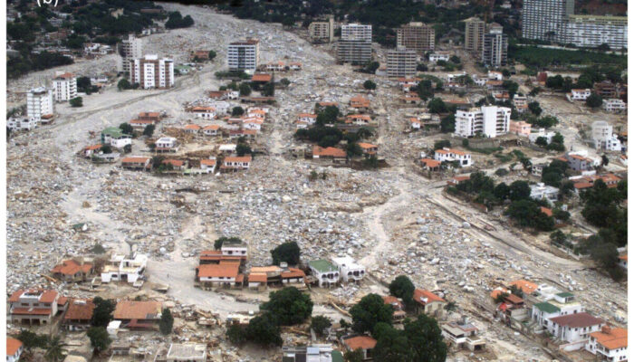
Thirty years ago, in August 1996, a catastrophic flash flood swept through the Las Nieves campsite on the alluvial fan of the Barranco de Aras near Biescas in the Central Pyrenees of Aragón, Spain. The tragedy claimed 87 lives and injured over 180 people. This makes it one of the most severe weather-related disasters in modern European history.
In the decades following the disaster, geoscientists have analysed the mechanisms that transformed a summer storm into an overwhelming surge of water, sediment, and debris. Published in Natural Hazards and Earth System Sciences (NHESS), research on the Biescas tragedy has redefined our understanding of cascading anthropogenic or natural hazards, mountain check-dam dynamics, and urban spatial planning on alluvial fans.
The event was triggered when extreme atmospheric instability produced localised torrential rainfall over the upper reaches of the Arás basin. As documented by Tamir Grodek and Gerardo Benito in their paper,
“The Biescas flood occurred in the Central Pyrenees in August 1996 (causing 87 deaths). The alluvial fan of the Rio Barranco de Aras was prone to flooding. Between 1926 and 1943, 36 check dams were built in the steep basin to protect the road to France. In August 1996, > 200 mm of rain fell in 2 h, producing a flood peak of > 400 m3 s−1, breaching a sequence of 32 out of the 36 check dams and entraining 0.17 Mm3 of 0.20 Mm3 of suspended sediment. The debris flow surge deposited at the fan head blocked the constructed mid-fan canal. The flow spread laterally, covering part of the fan, sweeping through a campsite and caravan park and dragging people and their caravans down to the Rio Gállego.”
In steep mountainous terrains, intense, short-duration rainfall converts quickly into high-velocity surface flows. However, high rainfall intensity alone does not quite explain the destructive magnitude of the flood to its fullest. The primary amplifier was the failure of the structural flood control measures installed decades prior.
Engineering failures and the “Levee Effect”
To protect regional transportation routes, specifically the main road connecting Spain to France, engineering projects constructed a network of 36 check dams along the steep stream channels upstream of Biescas between 1926 and 1943. These torrential control structures were designed to trap sediment, reduce channel gradients, and prevent bed erosion. For decades, the system appeared effective. However, scientific evaluations demonstrate that structural mitigation measures carry inherent long-term vulnerabilities when subjected to extreme events. Highlighting how retention structures can inadvertently create a severe secondary hazard, Grodek and Benito note that:
“While these structures successfully mitigate the hazards of sediment transport to the alluvial fan, they themselves become vulnerable to damage from the retained sediments…”
During the August 1996 storm, unprecedented discharge overwhelmed the sediment-filled basins behind the aging check dams, which, of course resulted in a catastrophic reaction: as dams broke, the sudden release of water and stored sediment increased the stress on downstream structures, causing 31 of the 36 check dams to collapse in rapid succession.
The flood transformed from a water flood into a dense, destructive debris flow carrying significant sediment loads. When this mass reached the apex of the alluvial fan, it clogged the artificial discharge canal designed to route water safely past the area. Denied its artificial path, the debris flow breached the canal walls and spread across its natural, historical path, the active surface of the alluvial fan where the campsite had been constructed.
The presence of structural measures like check dams and artificial channels frequently creates a false sense of security among local planners and the public. The presence of these historical measures led planners to assume the alluvial fan had been permanently stabilised, making the land safe for commercial camping. When the engineering structures failed, the exposure of human life on the fan surface produced catastrophic consequences.
Rethinking spatial planning for alluvial fans
Thirty years after Biescas, geoscientists argue that traditional engineering approaches that rely solely on hard structural barriers in mountain basins must be re-evaluated. Mountain check dams inevitably fill with sediment or suffer structural fatigue, and this requires continuous maintenance. When extreme storms exceed historical records, degraded structures become liability multipliers rather than protective shields.
In response, scientists propose a shift in disaster risk reduction strategies on urbanised and active alluvial fans. Rather than attempting to completely block sediment transport in upper canyons, future planning must incorporate nature-based solutions and spatial redesign that accommodate natural fan dynamics.
As published by Grodek and Benito:
“Findings from disastrous events worldwide, together with 60 years of flood monitoring in the city of Eilat, highlight the potential for incorporating flood management within urbanised alluvial fans. It has been shown that, for long-term safety, the steep mountain basin should remain natural to allow the continuous evacuation of sediments. On the alluvial fan, the strategic placement of recreation areas, radial roads, and parks can effectively create space for incoming water and sediment.”
Furthermore, they also outline concrete land-allocation guidelines necessary to prevent future Biescas-scale disasters:
“Our approach to disaster risk reduction proposes a shift in urban planning priorities to incorporate flood management by allocating 20 %–35 % of the alluvial fan – including the fan head and several wide radial road corridors down to the fan toe – for stream migration and sediment deposition.”
Thus, designing dedicated corridors across alluvial fans that can safely absorb hyper-concentrated flows and debris during rare extreme storms enables municipalities to protect human and non-human lives without relying solely on fragile, hard-engineering barriers.
As climate change accelerates the frequency of extreme weather, how will several communities globally adapt their land-use planning to work with nature rather than against it?…