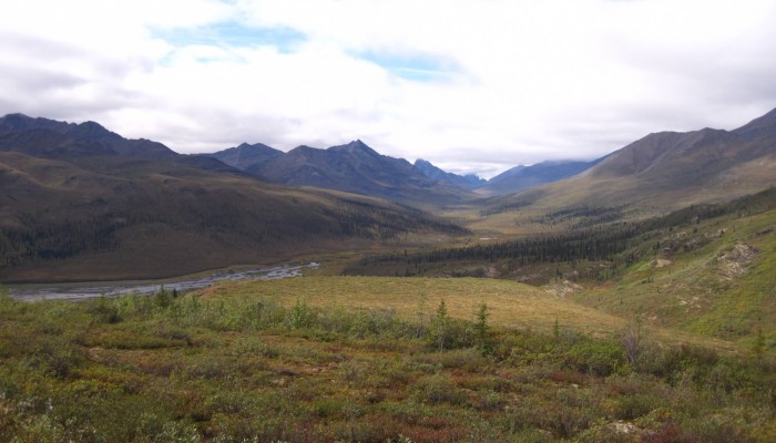
This week’s Imaggeo image is brought to you by one of our network bloggers, Matt Herod. Of the image, Matt said ” this particular one is one of my all time favourites. I have even blown it up and hung it on my wall at home,” and we couldn’t agree more; this Canadian landscape is breathtaking. Dive into this post and let Matt take you on a tour of the hydrology, archaeology and volcanic history of the Tombstone Mountain Range.
The Yukon Territory in the fall is a wonderful place and may be among the most beautiful on Earth. As the days shorten the colours become more vibrant and the grasses and shrubs transform. Combine this with the stark and rugged nature of the landscape and you have a potent combination that begs to be explored and photographed.
The subject of this photo is the Tombstone Mountain Range just north of Dawson City, a world heritage site famous for its gold rush, the Sourtoe Cocktail and the funnest casino I have ever been to. The Tombstones constitute the headwaters of the North Klondike River which flows at the base of the valley in the photo and eventually meets up with the larger Klondike River and then joins with the Yukon River at Dawson. Hydrologically the Tombstones mark a continental divide and the transition from southern flowing rivers to northern ones takes place nearby as the many of the rivers just slightly to the north feed into the Peel River and eventually the mighty Mackenzie. A colleague of mine recently concluded a project on the North Klondike measuring the groundwater discharge and chemistry of the river over several years to understand the water sources and the effect of permafrost on the local hydrology.
Indeed, at the base of the valley there is a groundwater discharge point that builds up every winter into a large, layered sheet of ice called and aufeis. As the warmer groundwater continues to discharge throughout the winter it freezes when it meets the cold air forming the aufeis. These structures are often seen at groundwater discharge points in the far north.
The Tombstones themselves, named after the really pointy mountain in the background, are geologically very interesting. Indeed, this relief was created by igneous intrusions during the Cretaceous period. More recently, alpine glaciations shaped the terrain giving rise to a suite of interesting geomorphological and permafrost structures.
The region also has a fascinating archeological heritage and is home to over 70 sites dating back ~8000 years to the Holocene period and some of the earliest human incursions into North America via the Bering land bridge.
This photo was taken in August 2012 on my way up the Dempster Highway. I was collecting water samples for iodine-129 analysis and stopped off in the Tombstone Territorial Park for a sample.
By Matt Herod, researcher at Department of Earth Sciences at the University of Ottawa in Ontario, Canada.
Imaggeo is the EGU’s online open access geosciences image repository. All geoscientists (and others) can submit their photographs and videos to this repository and, since it is open access, these images can be used for free by scientists for their presentations or publications, by educators and the general public, and some images can even be used freely for commercial purposes. Photographers also retain full rights of use, as Imaggeo images are licensed and distributed by the EGU under a Creative Commons licence. Submit your photos at http://imaggeo.egu.eu/upload/.


